New Snow Total Map For Storm Saturday
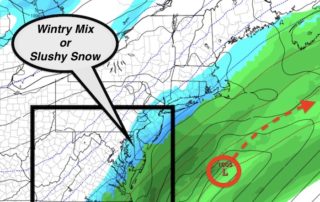
Friday December 8 The new computer models are confirming what I wrote in my prior post. The storm does appear to be over achieving. It already has done so to
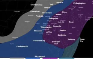
Friday December 8 The new computer models are confirming what I wrote in my prior post. The storm does appear to be over achieving. It already has done so to
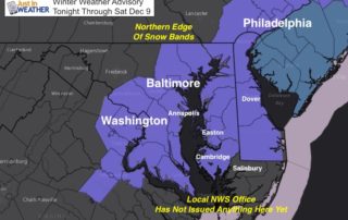
Friday December 8 2017 The the storm in the Southern US has steadily shown its hand to shift the track farther inland for us on Saturday. You may see flurries
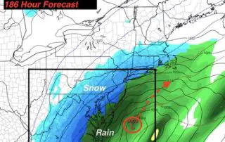
Thursday December 7 We have our first snow event on the way and it is a bit of a surprise. There is potential for some to get 1 to 3
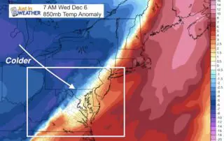
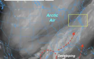
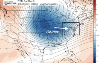
Wednesday December 6 The arctic front has moved through and strong winds are ushering in the colder air. Wind gusts this morning have been measured over 30 mph. While the
Tuesday December 5 2017 Temperatures are mild this morning and it will warm to the 60s today, but that comes with the price tag of rain. Some early fog as
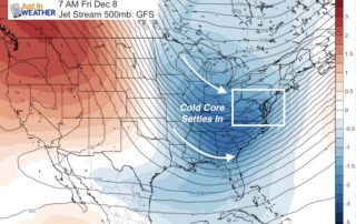
Thursday November 30 2017 The latest model plot from the GFS shows the arctic front next week passing through and then developing a coastal storm. This particular model now shows
November 30 2017 Baltimore hit 67ºF yesterday but that is now a memory. We begin our slide back to near normal temperatures into the weekend. This will come with some

Wednesday November 29 If you snow and are anxious for winter please know I am not worried about this warm spell. In fact, I believe the combination of the cold
Tuesday November 28 The mornings may seem like typical cold for late November weather, but the afternoons will continue to be warmer than normal. That is a symbol of the
Monday November 27 After a mild end to the holiday weekend, our weather pattern is uneventful. The initial cold surge has come and gone. Temperatures are seasonable, but colder in