 Tuesday December 5 2017
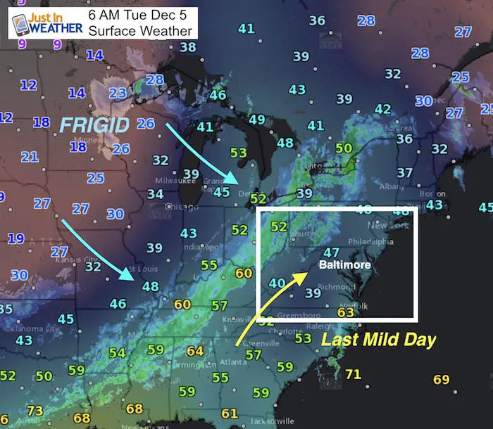
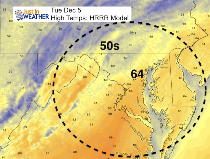
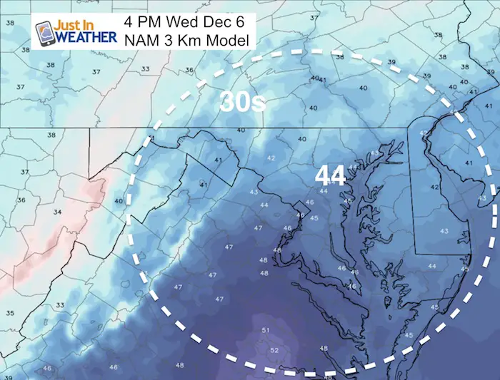
Temperatures are mild this morning and it will warm to the 60s today, but that comes with the price tag of rain. Some early fog as we starting in the 40s. Drizzle will develop during the morning but the rain will be moving in this afternoon and most of us will be under wet weather for the ride home. This is part of the arctic front, and it will swing through tonight. You might be lucky to have a sleet pellet mixed in this evening, but no stickage with the warm ground. Then we turn colder! Tomorrow afternoon will be close to 20 degrees colder, and that is just the beginning of the pattern change.
FITF Day
I am not expecting snow, but hope you wear your Faith in the Flakes gear as we celebrate the date for the first day of snow in Baltimore almost every year last decade. This is a month that brings an average of 3 inches of snow and we have some to talk about before the week is done. See more about December 5 Snow history here
Stats For December 5
Normal High: 49ºF
Record High: 75ºF in 2001
Normal Low: 31ºF
Record Low: 16ºF in 1966; 1926; 1886
Snow Record: 7.4″ in 2003
Sunrise: 7:11 AM
Sunset 4:44 PM
Simulated Radar
[metaslider id=55244]
High Temperatures Today
High Temperatures Wednesday
Front Stalls Along The Coast
This will be the first test of my Atmospheric Memory Theory this season. My winter outlook pointed to the tropical pattern shifting storms east and too far off of the coast. That is why I held back on this storm that models now agree will be well off of the coast. At this time it looks close enough to keep the risk of light snow or wintry mix on the Eastern Shore. Marginal temps may not allow for stickage… but the timing of the day could help with some snow laying and staying on the grass before sunrise.
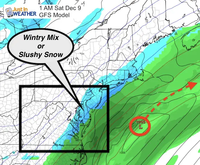
Animation:
This system pulls away and an upper level disturbance could bring snow showers Sunday. There will be more energy next week. I think this may be more organized than showing now and we could have a better chance for light snow.

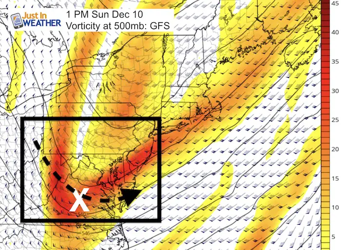
Sunday Snow Showers
All based on the voracity or spin aloft around 18,000 Ft… This is the sort max swinging through Sunday afternoon. It’s a good spot to help produce flurries or snow showers without and organized surface feature.
Keep In Touch All Winter
Click here to sign up for email alerts…. Just in case you don’t get the post on your social media feed
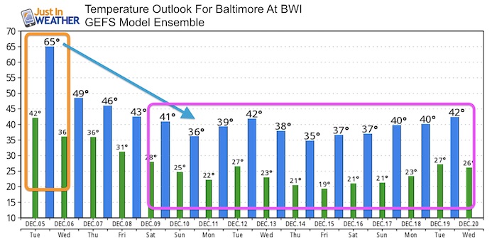
Temperature Outlook Below
Get your FITF Gear Here
Snowstix- New Colors in 30″ and 36″
We are giving 10% of each sale to programs that benefit pediatric oncology patients.

Faith in the Flakes Online Store
PJ bottoms still inside out- They have to be to help bring on the snow.

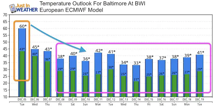
Temperature Outlooks
The European Model looks even colder
 Get the award winning Kid Weather App I made with my oldest son and support our love for science, weather, and technology. Our 3 year anniversary of the release and our contribution to STEM education is this November. It has been downloaded in 60 countries, and works in both temperature scales. With your support we can expand on the fun introduction to science and real weather.
Please share your thoughts, best weather pics/video, or just keep in touch via social media
-
Facebook: Justin Berk, Meteorologist
-
Twitter: @JustinWeather
-
Instagram: justinweather
Also See:
My Winter Outlook 2017-2018 for more snow
La Nina Formed: What it could mean to our winter
NOAA Winter Outlook: Not The Best But Not The Worst For Snow
Two Farmers Almanacs Winter 2018 Outlooks
Winter Weather Folkore: Suggestions from Animals and Crops
First Frost and Freeze Dates For Maryland (southern PA and northern VA)
My Preliminary Winter Outlook Notes
Low Snow Winters In Baltimore: To Repeat Or Not Repeat
NOAA Ranks Blizzard 2016 4th Worst Snowstorm On Record
Blizzard 2016 Record Top Snowstorm: Area Totals
Extreme Weather of 2015 balanced out on both ends