Friday December 8 2017
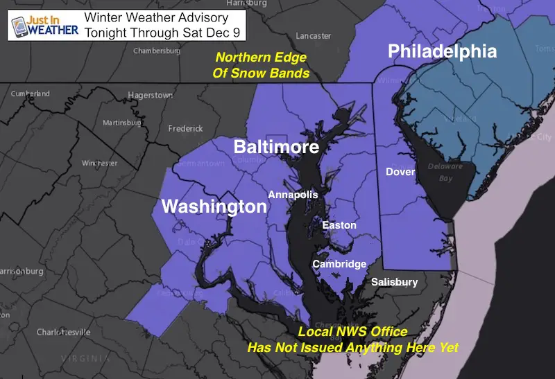
The the storm in the Southern US has steadily shown its hand to shift the track farther inland for us on Saturday. You may see flurries today, but the main even arrives tonight and. Saturday morning. We have a Winter Weather Advisory for a range of 1 inches on the low end to 4 inches on the high side (away form the water). Some areas not shaded in because the local NWS office has not posted advisories yet. NWS has increased the snow for metro Baltimore higher than my suggestion, and I will explain below.
The will be cold air in place, but the contrast of warming from the Chesapeake Bay will make the more complicated. However the early arrival this later today and more snow falling overnight will play more favorable to compensate for warm ground and stickage on area roads. Saturday morning will be slick for much of our region. We have a range of just flurries and a dusting to some places up to 4 inches or more. There is so much to discuss, so please read the notes with my maps below.
For Starters:
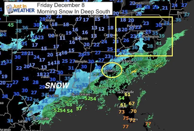
This storm has brought snow to Houston, TX and the Deep South! This map below was made with the 6 AM reports. I will be watching Atlanta, GA as they are on the fence for icy and snowy weather. If they end up warmer with less wintry ‘stuff’, that could indicate this storm will move even farther north/west and bring more of our inland areas into play tonight and Saturday.
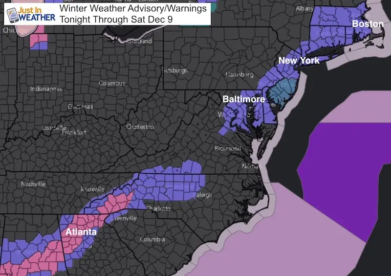
Winter Weather Advisories (Purple) and Winter Storm Warnings (Pink)
Stats For December 7
Normal High: 47ºF
Record High: 74ºF in 1980
Normal Low: 30ºF
Record Low: 10ºF in 1882
Snow Record: 4.1″ in 1989
Sunrise: 7:14 AM
Sunset 4:44 PM
*Bay Water Temperature = 50ºF at Thomas Pt Light House
Keep In Touch All Winter
Click here to sign up for email alerts…. Just in case you don’t get the post on your social media feed
About The Storm For Us:
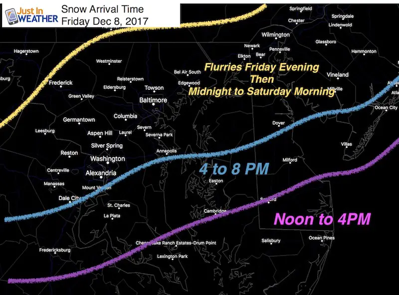
Snow Arrival Time
Temperature
This is important to consider stickage and accumulation. The snow falling at night will help to counter the warm ground. But during Saturday it will be marginal near the Bay and Delmarva. So there will be some flakes wasted to melting and compaction of heavy wet snow.
This is why my totals are a little lower than NWS
—> slider: Every 6 Hours
[metaslider id=55340]
Saturday Storm Map
The GFS (along with many others) shows the peak of this event at daybreak on Saturday morning but lasting into the afternoon. I see the Friday night snow making for widespread slick travel at daybreak Saturday. The snow during the day will continue but a better chance for wet roads after 10 AM.
*West edge of snow: Often the dry air makes for a sharp cut off. This may be near York to Frederick but this maps shows it farther west.
Delmarva: Southern Maryland will have heavy wet snow and mixing. Salisbury may mix during Saturday and then end with moderate snow in the afternoon. I see the highest totals in central Delmarva with up to 4 inches possible. Lower for places by the warmer water.

My Call For Snowfall
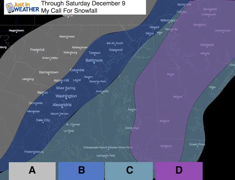
A: Back Edge of Storm = Flurries after midnight.
Light snow possible if there is a shift west. Lower impact but a dusting to 1 inch possible if we get that shift.
B: Metro Areas Along I-95 = 1 to 3 inches
Light and steady snow most likely midnight into Saturday morning. It will be slippery at daybreak Saturday and snow through mid day at least. NWS is going 2 to 4 inches in this zone.
C: Bay and Coastal Areas = 1 to 2 inches by the water
Steady snow, some mixing. Beach will get rain ending as snow Saturday, especially noon until evening.
D: Central Delmarva: 2 to 4 inches (isolated higher amounts)
On the edge of warm air and heavy snow. If they mix over to sleet or rain, it will turn to all snow before noon Saturday. Plan for slippery travel Friday night and most of Saturday.
Snowstix- New Colors in 30″ and 36″
We are giving 10% of each sale to programs that benefit pediatric oncology patients.

More Snow?
Mountains get snow Saturday night. Local areas could get flurries Sunday morning.
Tuesday: Next event worth watching.

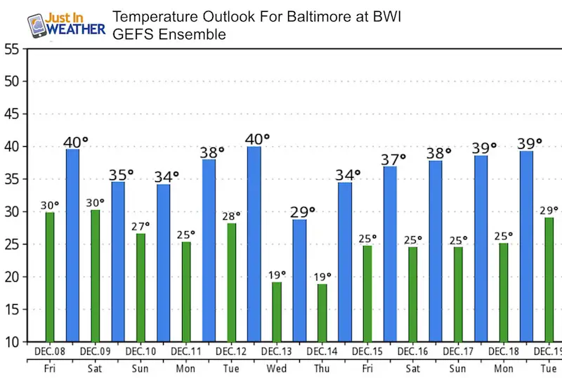
Temperature Outlook
Faith in the Flakes Online Store
PJ bottoms still inside out- They have to be to help bring on the snow.

 Get the award winning Kid Weather App I made with my oldest son and support our love for science, weather, and technology. Our 3 year anniversary of the release and our contribution to STEM education is this November. It has been downloaded in 60 countries, and works in both temperature scales. With your support we can expand on the fun introduction to science and real weather.
Please share your thoughts, best weather pics/video, or just keep in touch via social media
-
Facebook: Justin Berk, Meteorologist
-
Twitter: @JustinWeather
-
Instagram: justinweather
Also See:
My Winter Outlook 2017-2018 for more snow
La Nina Formed: What it could mean to our winter
NOAA Winter Outlook: Not The Best But Not The Worst For Snow
Two Farmers Almanacs Winter 2018 Outlooks
Winter Weather Folkore: Suggestions from Animals and Crops
First Frost and Freeze Dates For Maryland (southern PA and northern VA)
My Preliminary Winter Outlook Notes
Low Snow Winters In Baltimore: To Repeat Or Not Repeat
NOAA Ranks Blizzard 2016 4th Worst Snowstorm On Record