 Friday December 8
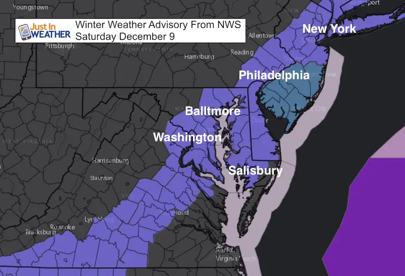
The new computer models are confirming what I wrote in my prior post. The storm does appear to be over achieving. It already has done so to our south and the expectation now is for a wider impact storm to spread more snow and slightly higher totals. Before I get to the maps, the Winter Weather Advisory posted by the National Weather Service will be upgraded for some areas in the next few hours. This will account for more snow. Please keep these things in mind:
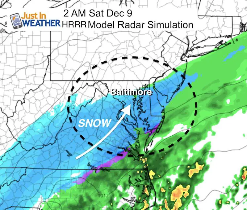
- Arrival Time Before Sunrise: Light snow will reach southern areas of our region today, but the main event will spread over our region between midnight and 4 AM. Getting snow to develop prior to sunrise Saturday will allow for the ground to cool quickly. Thus, snow will lay and stay and make for slippery travel.
- Warm Bay: Yes the water temperatures are around 50ºF. That makes nearby areas likely to have less accumulation. It can snow a lot during Saturday and not add up to much near the water.
- Snow will fall and stick in some areas NOT under and advisory now. I added parts of western Maryland and southern Pennsylvania in my snow map below. They may be part of the advisory, but NWS State College PA has stricter designation than NWS Sterling VA office.
- Heaviest snow will be at daybreak until lat morning or noon. It will snow into the afternoon, but roads that have been treated will be passable as temperatures will be marginal in metro areas. Roads will remain slippery north and west of Baltimore where temps could be in the upper 20s.
Arrival Of Snow Between Midnight and 4 AM (for most)
My Final Call For Snowfall
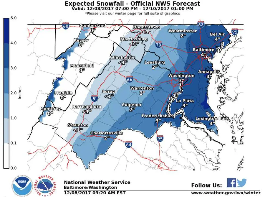
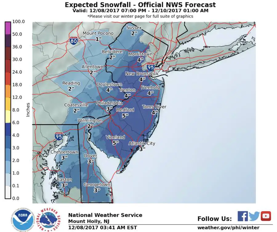
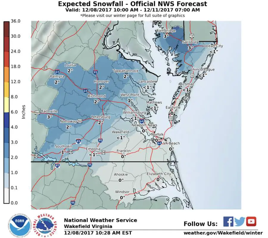
National Weather Service Snow Maps and storm animation are below
Also see my prior report on how close this is to a major storm: Almost Phasing
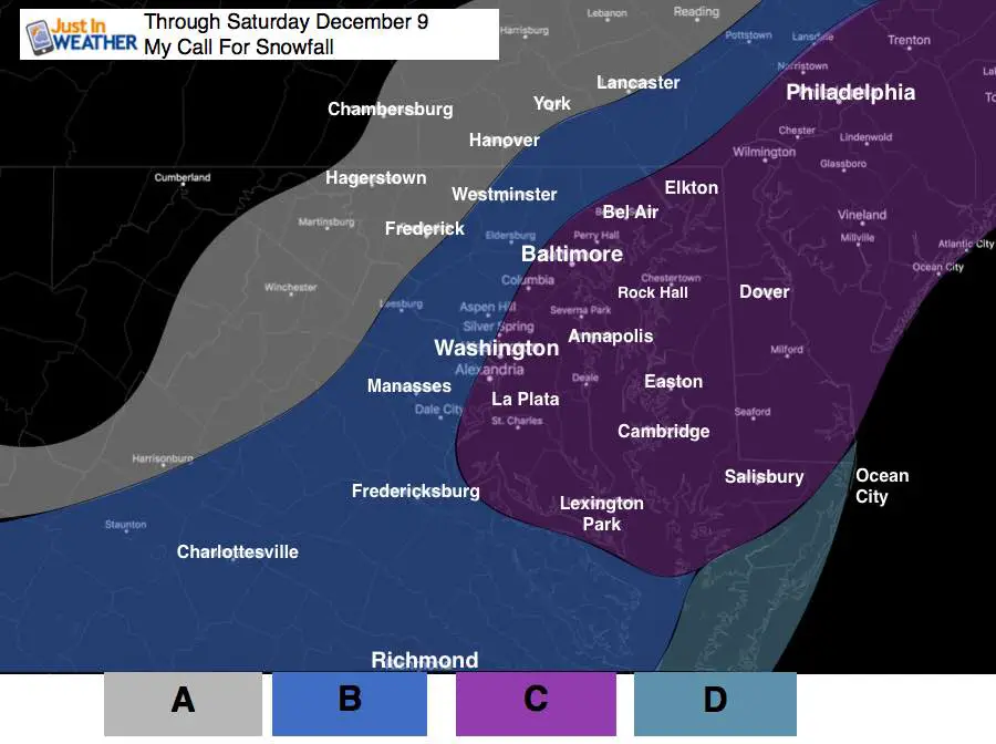
A: Maybe a dusting or slightly more
Flurries or light snow on back edge of snow.
B: 1 to 3 inches
Steady light snow begins before sunrise and lasts into the afternoon. Roads more likely to be slick through mid day.
C: 2 to 5 inches
This wider range is due to the warming from the Chesapeake Bay. Heaviest snow will fall in this zone and some spots could get more. But the overall range should verify with melting and compacting. Roads will be slick early but may be passable after 9 or 10 AM. More snow will lingering later afternoon and evening on the Delmarva.
D: Dusting to 3 inches
Coastal areas will be warmer and may go from snow tonight to rain, then back to snow. Their accumulation could be split tonight and then again Saturday afternoon and evening.
Snowstix- New Colors in 30″ and 36″
We are giving 10% of each sale to programs that benefit pediatric oncology patients.

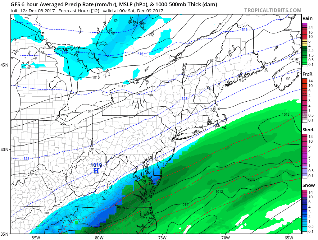
Latest GFS Model Animation:
National Weather Service Zone Maps for Snow
Faith in the Flakes Online Store
PJ bottoms still inside out- They have to be to help bring on the snow.

Keep In Touch All Winter
Click here to sign up for email alerts…. Just in case you don’t get the post on your social media feed.
 Get the award winning Kid Weather App I made with my oldest son and support our love for science, weather, and technology. Our 3 year anniversary of the release and our contribution to STEM education is this November. It has been downloaded in 60 countries, and works in both temperature scales. With your support we can expand on the fun introduction to science and real weather.
Please share your thoughts, best weather pics/video, or just keep in touch via social media
-
Facebook: Justin Berk, Meteorologist
-
Twitter: @JustinWeather
-
Instagram: justinweather
Also See:
My Winter Outlook 2017-2018 for more snow
La Nina Formed: What it could mean to our winter
NOAA Winter Outlook: Not The Best But Not The Worst For Snow
Two Farmers Almanacs Winter 2018 Outlooks
Winter Weather Folkore: Suggestions from Animals and Crops
First Frost and Freeze Dates For Maryland (southern PA and northern VA)
My Preliminary Winter Outlook Notes
Low Snow Winters In Baltimore: To Repeat Or Not Repeat
NOAA Ranks Blizzard 2016 4th Worst Snowstorm On Record