Storm Damage Photos Around Baltimore County August 3 2017
Friday August 4 The severe thunderstorm that hit Baltimore County around 5:30 PM Thursday August 3 2017 produce amazing cloud formation and incredible damage. The first image here over Towson
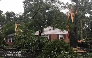
Friday August 4 The severe thunderstorm that hit Baltimore County around 5:30 PM Thursday August 3 2017 produce amazing cloud formation and incredible damage. The first image here over Towson

Friday August 4 Much of this week has featured severe weather across central Maryland, but Thursday August 3 it was centered on Baltimore County. The storm that moved through between
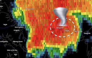
Monday July 24 2017 The National Weather Service has completed their damage assessment of Stevensville and Bay City on Kent Island, Maryland. They have confirmed that the tornado began as
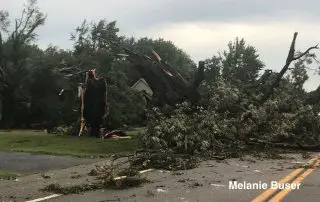
July 24 2017 The 15 images here across Stevensville and Bay City on Maryland's Kent Island are the result of the storm that hit at 1:30 AM this morning. A

Monday July 24 There will be heightened awareness and anxiety today following the likely tornado that hit Kent Island early this morning. Storms will develop and there is a marginal

Monday July 24 After a very stormy weekend, the cell that developed after midnight was the peak performance. I often point out the heat of the day brings the most

Sunday July 23 The good news is that we do NOT have a Heat Advisory today, but that doesn't take away form the uncomfortable humidity. Temps will aim for near

Saturday July 22 It may seem like just another hot day in this stretch as the sky is hazy and only partially filled with clouds at noon. But Doppler Radar

July 15 2017 There was a little storm Saturday morning the passed over the Chesapeake Bay and developed a waterspout. This was a long rope that made splashdown and was

July 1 2017 A Severe Thunderstorm Watch has been issued for much of our area until 9 PM this evening. This includes southern Pennsylvania, central Maryland, VA Washington suburbs, and