 Monday July 24 2017
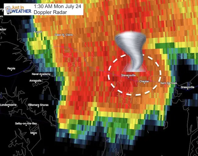
The National Weather Service has completed their damage assessment of Stevensville and Bay City on Kent Island, Maryland. They have confirmed that the tornado began as a waterspout and made landfall with EF-2 rating on the Enhanced Fujita scale. The top winds were 125 mph. This is higher than the 86 mph estimated winds by Doppler Radar.
Note: The official path map has NOT been issued yet. I have not shared the map that is circulating online due to potential inaccuracies. This is a very sensitive matter due to pottery loss and insurance coverage. I prefer to get it right rather than be first. Please be patient. As soon as I see the official map, I will share it.
Note: This same area saw a waterspout over the Chesapeake Bay last week, and had another reported and document in August 2016. I have links to this stories below.
Here is the initial report from The National Weather Service Mount Holly team
Location…Bay City and Stevensville in Queen Anne’s County Maryland
Date…07/24/2017
Estimated Time…0129 AM EDT
Maximum EF-Scale Rating…EF2
Estimated Maximum Wind Speed…125 mph
Maximum Path Width…150 yards
Path Length…2 miles Beginning
Lat/Lon…38.970809, -76.343164
Ending lat/Lon…38.979050, -76.308880
* Fatalities…0
* Injuries…1
* The information in this statement is preliminary and subject to
change pending final review of the event(s) and publication in
NWS Storm Data.
…Summary…
Doppler Radar Loop: Likely Tornado On Kent Island July 24
Damage Photos Of Tornado Around Stevensville Maryland
The National Weather Service in Mount Holly NJ has confirmed a
tornado near Stevensville in Queen Anne’s County Maryland on
07/24/2017.
A waterspout developed over the Chesapeake Bay between Annapolis
and Stevensville, Maryland just south of the Chesapeake Bay Bridge
as estimated by radar velocity from the Baltimore-Washington
Airport Terminal Doppler Weather Radar. The waterspout moved
ashore at 129 AM in the Bay City Area of Kent Island and then
traveled northeast toward Stevensville, Maryland where it lifted
at 133 AM after being on the ground for about 2 miles.
Maximum winds were estimated at 125 mph which makes this an EF2
tornado. Several wood framed townhomes had the upper floors
entirely lifted off along with the roof; several other homes had
either roofs lifted off and tossed or received other damage. One
business was destroyed. There was one injury to a person who was
punctured by debris. In addition, there were trees and power lines
down and some gas leaks were reported along with a structure fire
to a home.
Additional information will be added to this report once the
survey team returns to the Mount Holly NWS office this evening.
Also see:
Doppler Radar Loop: Likely Tornado On Kent Island July 24