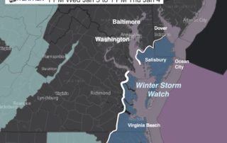
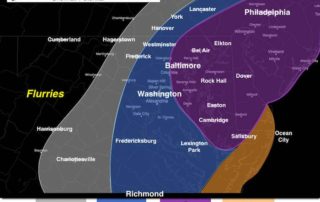
Coastal Storm Update: First Call For Snow January 3 and 4
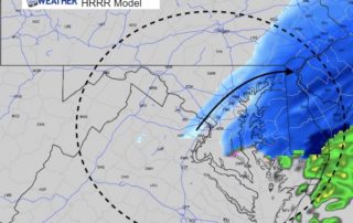
January 2 2018 A rare storm is about to develop and impact the southeastern and coastal US. The final hit of extremely cold air will be pushing south and interacting
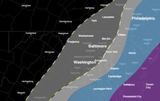
January 2 2018 A rare storm is about to develop and impact the southeastern and coastal US. The final hit of extremely cold air will be pushing south and interacting
January 2 2018 The return back to work and school comes with bitter cold air and a super moon. The moon was 221,584 miles away, compared to the average of

December 31 2017 We are closing out 2017 with fresh snow on the ground and bitterly cold air continuing to expand our way. A Wind Chill Advisory is in effect

Saturday December 30 2017 There is snow on the ground this morning and temperatures are cold. That means some untreated roads are slick, but will improve. The system came in

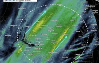
Friday December 29 2017 The wide view radar looks very impressive this evening. This image alone looks like we could have an overachiever, but there is more that could lean

Friday December 29 2017 A Winter Weather Advisory has been issued for northern Maryland north and west if I-95 and southern Pennsylvania for Saturday morning. The general idea is a
Friday December 15 2017 2 PM (reposted after site crashing) Light snow mixed with some sleet and freezing temperatures. That what we finally settled on and it has shown itself.
December 15 2017 10 AM (reposted after site crash) The small winter event on the way is causing big problems. First, the timing of the worst impact will be during

Friday December 15 This is the third light event that seemed to ramp up right right before reaching us. The trend is for us to get these systems to over
12:20 PM Saturday December 9 The storm is now doing what it was supposed to do and we are getting some adjustments to the advisories and warnings from the National