December 31 2017
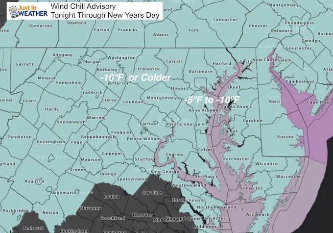
We are closing out 2017 with fresh snow on the ground and bitterly cold air continuing to expand our way. A Wind Chill Advisory is in effect tonight through Monday morning January 1 2018. This is for metro areas to have wind chill values between -5ºF and -10ºF, and inland areas colder than -10ºF. Plans to be outside may need to be reconsidered.
After the coldest New Year’s eve in half a century, there will be another surge of even colder air later in the week. More on that below.
Baltimore official recorded 0.5″ of snow for a total of 4.3″ for the month and season. This is more than an average December and more than all of last winter. I will have the complete snow report and grade my forecast later today.
Stats For December 31
Normal High: 42ºF
Record High: 72ºF in 1992
Normal Low: 25ºF
Record Low: -1ºF in 1880
Snow Record: 3.2″ in 1970
Sunrise: 7:26 AM
Sunset 4:54 PM
*Daylight = 37 seconds longer than yesterday
*Bay Water Temperature = 39ºF at Thomas Pt. Light House
Snow To Date (at BWI): 4.3″
Keep In Touch All Winter
Click here to sign up for email alerts…. Just in case you don’t get the post on your social media feed

Temperatures and Wind Chill
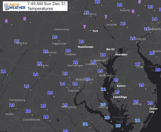
This Morning- It will be colder tomorrow…
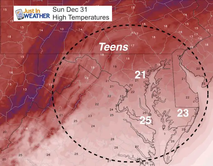
Today
High Temperatures: HRRR Model
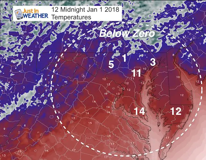
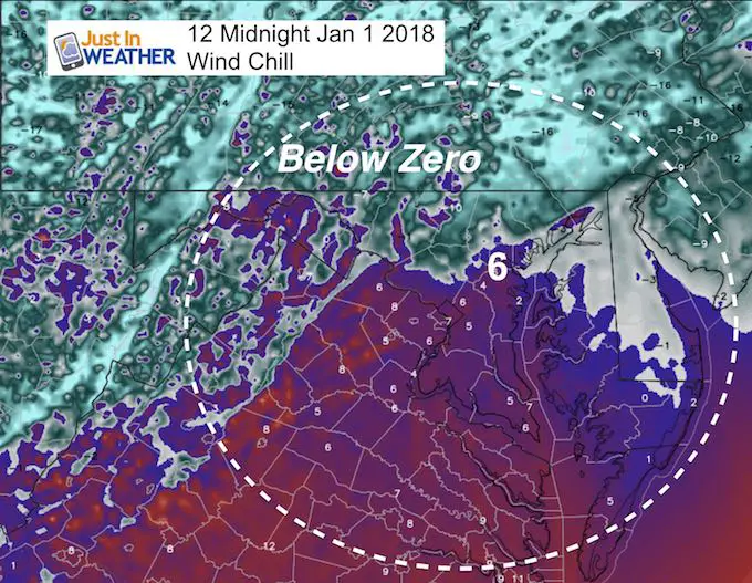
Midnight 2018
Yes, that is 11ºF in Baltimore and near or below zero to the north
Wind Chill At Midnight
This all depends on the wind at that time… It wil be getting colder all night long. Her we see an estimate of +6ºF in Baltimore, but -10ºF in Westminster and colder inland.
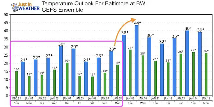
Temperature Outlook
Baltimore did hit 33ºF on Saturday, so the streak of below zero hours was broken, but we won’t get back there until next week… Monday January 8 at the earliest.
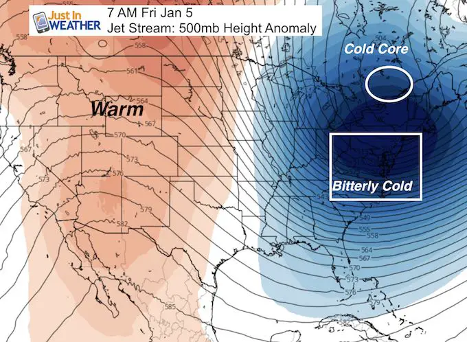
Jet Stream:
This is the reinforcing shot of arctic air on Thursday and Friday
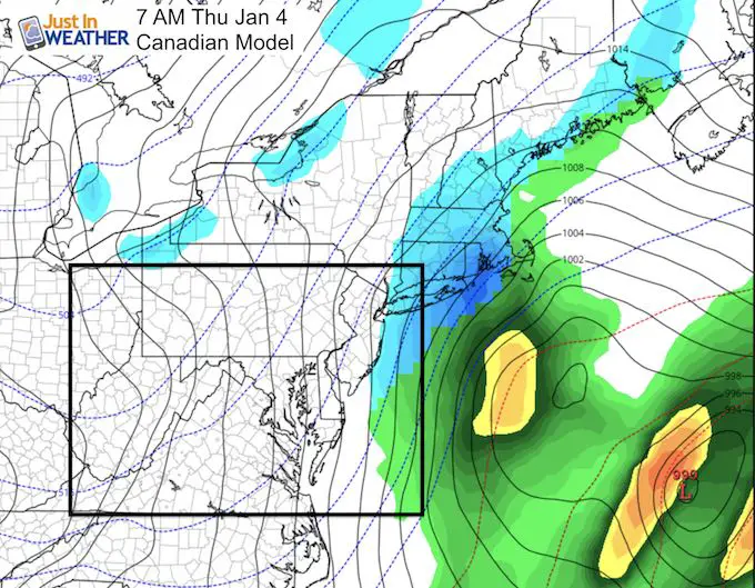
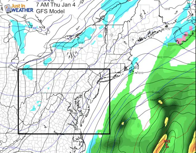
Coastal Storm- Pushed Too Far East
This is the pattern I suspected in my My Winter Outlook 2017-2018: Models will see a storm forming off of the coast a week away but it will not verify and end up farther east. This is the 4th time we have seen it this month. Here is the latest look at the Thursday January 4th setup. There may be some retrograde back to clip Ocean City with some snow, but I don’t see it hitting metro areas.
*But much like the even the had yesterday, I see more of these clipper style events.. and the ones that we do not see well ahead of that will impact us. Since there are no major events on modeling for the next 10 days at this moment, I actually think we will see another push of snow in the arctic air next weekend.
TOO FAR OFF OF THE COAST
Please share your thoughts, best weather pics/video, or just keep in touch via social media
-
Facebook: Justin Berk, Meteorologist
-
Twitter: @JustinWeather
-
Instagram: justinweather
FITF Gear

Snowstix- We Need You To Measure Snow Too
We are giving 10% of each sale to programs that benefit pediatric oncology patients.

 Get the award winning Kid Weather App I made with my oldest son and support our love for science, weather, and technology. Our 3 year anniversary of the release and our contribution to STEM education is this November. It has been downloaded in 60 countries, and works in both temperature scales. With your support we can expand on the fun introduction to science and real weather.
Keep In Touch All Winter
Click here to sign up for email alerts…. Just in case you don’t get the post on your social media feed
Also See:
My Winter Outlook 2017-2018 for more snow
La Nina Formed: What it could mean to our winter
NOAA Winter Outlook: Not The Best But Not The Worst For Snow
Two Farmers Almanacs Winter 2018 Outlooks
Winter Weather Folkore: Suggestions from Animals and Crops
First Frost and Freeze Dates For Maryland (southern PA and northern VA)
My Preliminary Winter Outlook Notes
Low Snow Winters In Baltimore: To Repeat Or Not Repeat
NOAA Ranks Blizzard 2016 4th Worst Snowstorm On Record