 Saturday December 30 2017
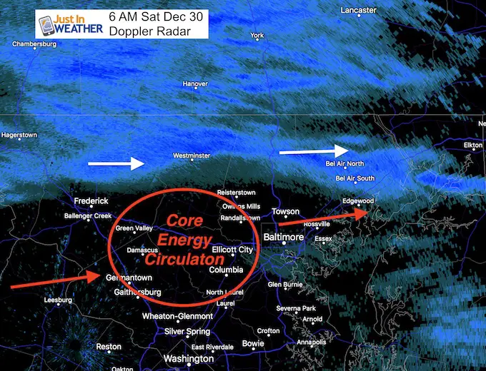
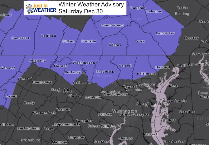
There is snow on the ground this morning and temperatures are cold. That means some untreated roads are slick, but will improve. The system came in early and is already on the way out for many. The Winter Weather Advisory was already canceled for Hagerstown and westward. If you read my post yesterday, I mentioned the core energy passing over Washington DC, but that any shift could spread or cut off the snow in central Maryland. Here we can see the 6 AM radar showing the band of snow wrapping around the core energy that tracked north of Washington and over Baltimore. This cut off the snow earlier for metro areas, while it is hanging on in northern Maryland and showing some stronger bands there. This lines up very well with my 1 to 3 inch snow zone. The secret is topography and climatology. There is a history of this and it proved true again today.
Below is a look at the radar simulation, which is already behind by an hour or two. Even on the north side, the snow will end this morning before noon. Snow totals should verify as I showed yesterday, and there may be one more snow shower during the afternoon. Then we focus on the temperatures.
Stats For December 30
Normal High: 42ºF
Record High: 68ºF in 1990
Normal Low: 25ºF
Record Low: -3ºF in 1880
Snow Record: 2.3″ in 1935
Sunrise: 7:26 AM
Sunset 4:53 PM
*Daylight = 32 seconds longer than yesterday
*Bay Water Temperature = 38ºF at Thomas Pt. Light House
Snow To Date (at BWI): 3.8″
Keep In Touch All Winter
Click here to sign up for email alerts…. Just in case you don’t get the post on your social media feed

Doppler Radar at 6 AM
Radar Simulation
Notice the 6 AM plot from the HRRR Model was farther south… Also not the snow lingering near the PA line for a few hours as the core energy moves along the track to the east northeast.
[metaslider id=56356]
My Snow Forecast
I am still standing by my original call
The cold air and fluff factor comes into play with wider range up north
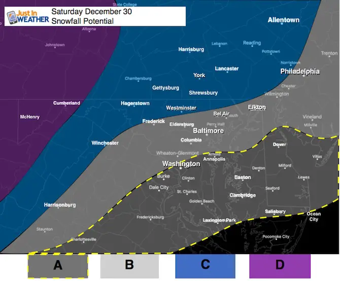
A: Flurries to a Dusting
This area will be on the southern edge of this event
B: Dusting To 1 Inch
This area will have light snow in the morning until noon. Temps will be cold and this will be fluffy snow. High Temps should reach 30ºF to 32ºF here. Then drop into the teens overnight.
C: 1 to 3 inches
This is the typical northern zones that gets more snow. It wil last longer and afternoon snow showers may add a little more. The wide range will be based on hilltops and the fluffy snow with higher ratios. Temps should stay in the 20s during the day. May hit single digits Sunday morning.
D: 2 to 4 inches Plus
The mountains will have snow all day and get more. Great news for ski areas (Wisp, 7 Springs, Snowshoe, WV all on the plus side of this)
This Fits The Winter Weather Advisory where 1 inch or more is expected
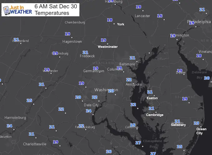
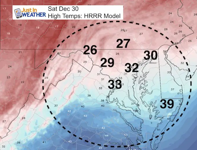
High Temperatures Today
Staying below freezing in areas that got near or more than 1 inch of snow.
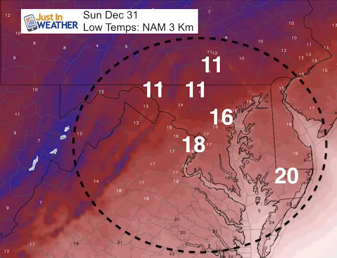
Low Temperatures Sunday
These are actual temperatures, NOT wind chill
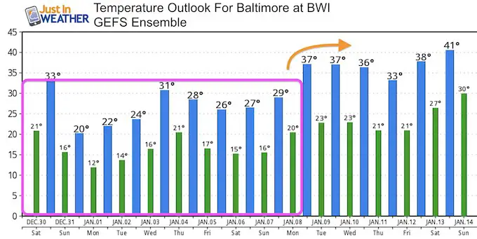
Outlook
- New Year’s Eve will be in the lower teens.
- We should remain below freezing through the first week of January.
Next Storm?
I did not trust the coastal storm during the first week of January and it has faded from the computer models. The trend too far east has proved itself again. I wrote about this in my Winter Outlook. I think our best bet will be these clippers and a storm from the south that is NOT seen on the modeling a week ahead of time.
My Winter Outlook 2017-2018 for more snow
Please share your thoughts, best weather pics/video, or just keep in touch via social media
-
Facebook: Justin Berk, Meteorologist
-
Twitter: @JustinWeather
-
Instagram: justinweather
FITF Gear

Snowstix- We Need You To Measure Snow Too
We are giving 10% of each sale to programs that benefit pediatric oncology patients.

 Get the award winning Kid Weather App I made with my oldest son and support our love for science, weather, and technology. Our 3 year anniversary of the release and our contribution to STEM education is this November. It has been downloaded in 60 countries, and works in both temperature scales. With your support we can expand on the fun introduction to science and real weather.
Keep In Touch All Winter
Click here to sign up for email alerts…. Just in case you don’t get the post on your social media feed
Also See:
My Winter Outlook 2017-2018 for more snow
La Nina Formed: What it could mean to our winter
NOAA Winter Outlook: Not The Best But Not The Worst For Snow
Two Farmers Almanacs Winter 2018 Outlooks
Winter Weather Folkore: Suggestions from Animals and Crops
First Frost and Freeze Dates For Maryland (southern PA and northern VA)
My Preliminary Winter Outlook Notes
Low Snow Winters In Baltimore: To Repeat Or Not Repeat
NOAA Ranks Blizzard 2016 4th Worst Snowstorm On Record