 January 2 2018
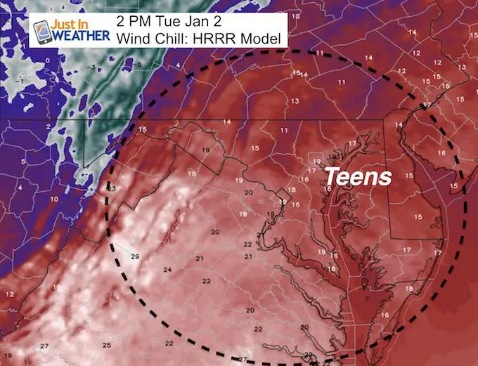
The return back to work and school comes with bitter cold air and a super moon. The moon was 221,584 miles away, compared to the average of 238,000 miles. That may add to the ‘wild factor’ for kids and the coastal storm. As a parent I need to say good luck top teachers. I know what you are looking ahead to and for now it looks like that ‘day off’ possibility is most likely on Maryland’s lower Eastern Shore and coastal Delaware. More on that storm below. Please consider that the back edge of snow showers or flurries will cut off near the western shore of the Bay, but strong winds for all of us will bring in wind chills below zero.
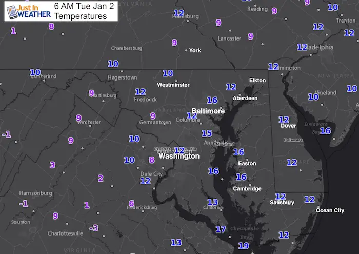
Today:
Stats For January 2
Normal High: 42ºF
Record High: 71ºF in 1876
Normal Low: 25ºF
Record Low: 0ºF in 1968
Snow Record: 7.9″ in 1925
Sunrise: 7:26 AM
Sunset 4:55 PM
*Daylight = 43 seconds longer than yesterday
*Bay Water Temperature = 36ºF at Thomas Pt. Light House
Seasonal Snow To Date (at BWI): 4.3″
Keep In Touch All Winter
Click here to sign up for email alerts…. Just in case you don’t get the post on your social media feed

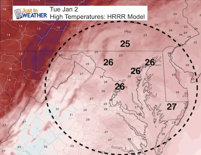
This Afternoon:
Skipping Ahead…
Winter Storm Watch Wednesday-Thursday
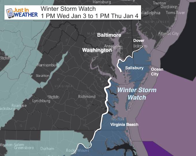
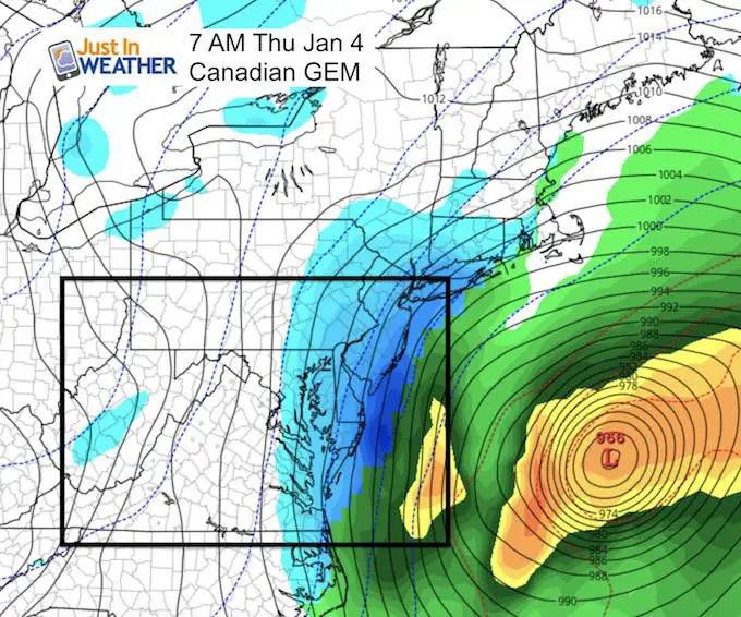
As I wrote last night, the developing coastal storm has appeared to back to the west a little but the tend has stalled. This will be a monster storm, however the back edge of the snow will cut off abruptly across Maryland. Flurries or light snow may clip Baltimore and Annapolis. As of now it looks like accumulating snow will be limited to extreme southeast Virginia, the lower Eastern Shore of Maryland, and coastal Delaware.
Thursday morning will be the most active time but the strongest winds will follow for all of us and last into Friday.
Forecast Maps:
The leading edge of snow will be moving in the region around midnight…
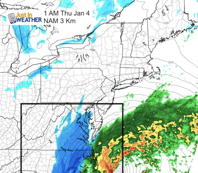
The Canadian Model is the farthest west with the back edge of snow. The light blue shows light snow or flurries into York, Baltimore, and Annapolis.Steadier snow on Delmarva with the heaviest along the coast….
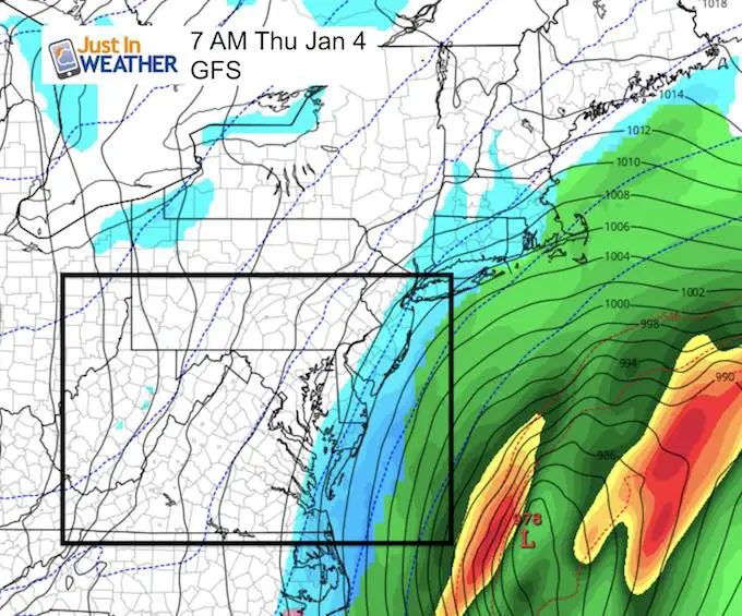
The GFS Model is farther off of the coast and shows coastal areas with the back edge of the light snow.
My first call for snowfall map will be posted this evening.
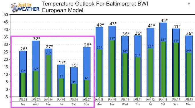
Temperature Outlook
We are promised colder air and stronger winds into the weekend. The ‘thaw’ from this deep freeze should be by Monday next week
Please share your thoughts, best weather pics/video, or just keep in touch via social media
-
Facebook: Justin Berk, Meteorologist
-
Twitter: @JustinWeather
-
Instagram: justinweather
FITF Gear

Snowstix- We Need You To Measure Snow Too
We are giving 10% of each sale to programs that benefit pediatric oncology patients.

 Get the award winning Kid Weather App I made with my oldest son and support our love for science, weather, and technology. Our 3 year anniversary of the release and our contribution to STEM education is this November. It has been downloaded in 60 countries, and works in both temperature scales. With your support we can expand on the fun introduction to science and real weather.
Keep In Touch All Winter
Click here to sign up for email alerts…. Just in case you don’t get the post on your social media feed
Also See:
My Winter Outlook 2017-2018 for more snow
La Nina Formed: What it could mean to our winter
NOAA Winter Outlook: Not The Best But Not The Worst For Snow
Two Farmers Almanacs Winter 2018 Outlooks
Winter Weather Folkore: Suggestions from Animals and Crops
First Frost and Freeze Dates For Maryland (southern PA and northern VA)
My Preliminary Winter Outlook Notes
Low Snow Winters In Baltimore: To Repeat Or Not Repeat
NOAA Ranks Blizzard 2016 4th Worst Snowstorm On Record