Chilly Rain Today And Irma Track Shifting Back
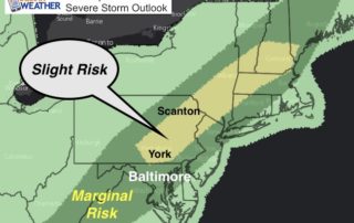
Wednesday September 6 Two main things to point out this morning: The cold front is stalled over our region and we will have more rain today as temperatures struggle in

Wednesday September 6 Two main things to point out this morning: The cold front is stalled over our region and we will have more rain today as temperatures struggle in

Tuesday September 5 Warm winds and a hazy sky today are indicators that the weather we have will not last much longer. A cold front is approaching form the west
Tuesday September 5 Today is the day Maryland goes back to school and it will feel like one last day of summer. Temperatures are warm this morning so I suspect
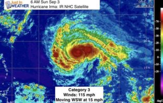
Sunday Sep 3 The remains of Harvey are to our north the rain is moving away. The winds will be shifting allowing the sky to clear and the sun to

Saturday September 2 The thing about today's weather is these remains of Harvey are exactly what we expected and it is a much diminished form than the Category 4 hurricane

The circulation of former Major Hurricane Harvey still dominates the radar map, but it is down to a tropical depression and will continue to weaken as it impacts our area.

Thursday August 31 Just when you thought summer weather was gone, we have a little warm up. Today will be back in the 80s and it looks like we will

Wednesday August 30 Tropical Storm Harvey made its second US landfall and third overall this morning. The winds were 45 mph as the center touched just west of Cameron Louisiana.

Tuesday August 29 The flooding from Harvey is still building in east Texas and the now tropical storm is poised to make another landfall on the border with Louisiana. But

Tuesday August 29 The chilly winds and steady rain today will hold our temperatures down in the 60s and will not feel anything like the end of August. Technically the