 Tuesday September 5
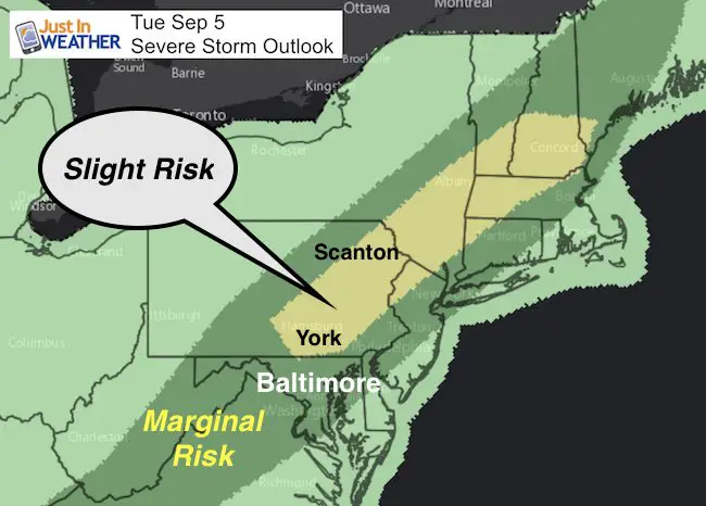
Today is the day Maryland goes back to school and it will feel like one last day of summer. Temperatures are warm this morning so I suspect it will be shorts for many. The risk of severe storms will build late afternoon through this evening and the rain will linger into Wednesday. The storms will be stronger north of Baltimore towards York and Lancaster PA. I know you are in a rush, so I will be quick about the rest. Below you will see the simulated radar, temperature outlook, and the latest on Hurricane Irma that has 150 mph winds but the track is continuing to stay south, but we could get rain from it next week.
—-> slider: Simulated Radar
[metaslider id=52536]
Note: The risk of strong or severe storms will be after 5 PM and the norther suburbs could see the stronger cell between 6 and 7 PM. Metro Baltimore, Washington, and Annapolis will have the best chance of storms this evening and overnight.
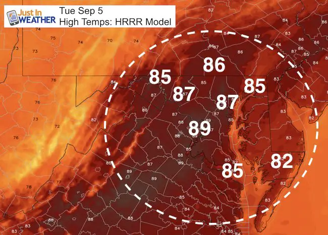
High Temperatures
Very warm reaching into the upper 80s
—> slider: Rain Timeline
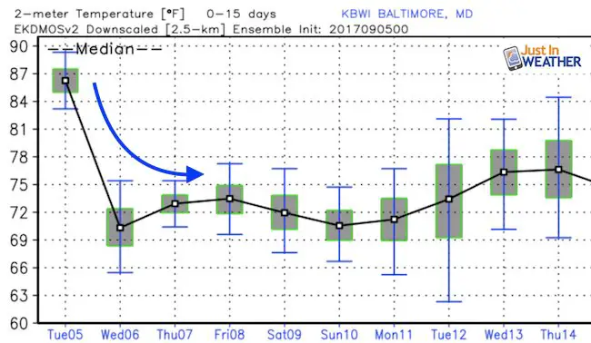
Rain will linger with cooler temps (lower 70s) Wednesday
[metaslider id=52556]
Temperature Outlook
Hurricane Irma
This is a brief update. I will have more details in my next report this morning
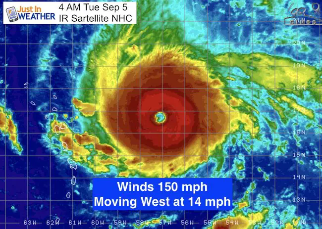
SUMMARY OF 500 AM AST…0900 UTC…INFORMATION
———————————————-
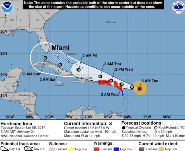
LOCATION…16.6N 57.0W
ABOUT 320 MI…515 KM E OF THE LEEWARD ISLANDS
MAXIMUM SUSTAINED WINDS…150 MPH...240 KM/H
PRESENT MOVEMENT…W OR 270 DEGREES AT 14 MPH…22 KM/H
MINIMUM CENTRAL PRESSURE…937 MB…27.67 INCHES
Forecast Track
The National Hurricane Center is sticking with that HWRF I showed last evening. Click here to see that animation here.
State Of Emergency for Florida. The trend is for south Florida and perhaps a turn north for the Gulf Coast into Georgia and then rain spreading our way next week.
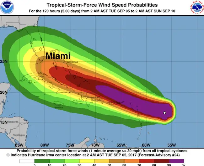
Wind Spread
SUMMARY OF WATCHES AND WARNINGS IN EFFECT:
A Hurricane Warning is in effect for…
* Antigua, Barbuda, Anguilla, Montserrat, St. Kitts, and Nevis
* Saba, St. Eustatius, and Sint Maarten
* Saint Martin and Saint Barthelemy
* British Virgin Islands
* U.S. Virgin Islands
* Puerto Rico, Vieques, and Culebra
A Hurricane Watch is in effect for...
* Guadeloupe
A Tropical Storm Warning is in effect for…
* Guadeloupe
* Dominica
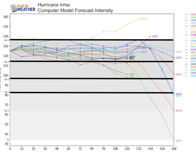
Intensity Forecast: Remaining A Major Hurricane Until Reaching The US
Computer Model Forecast Tracks
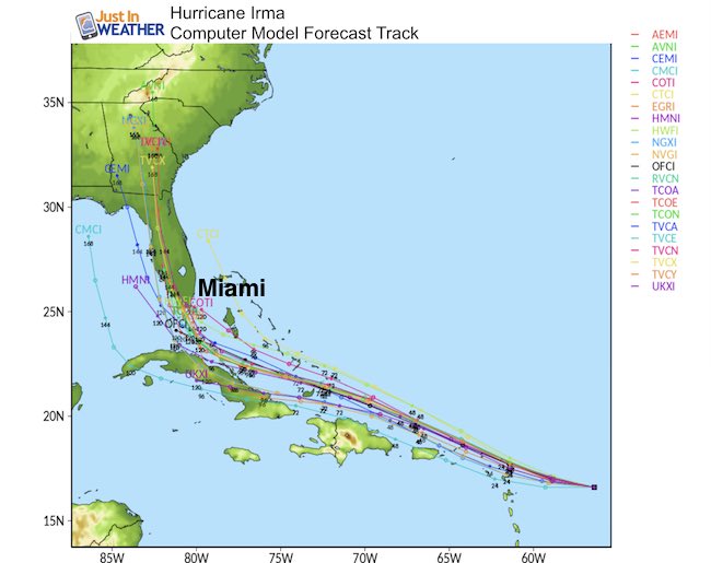
Long Range Outlook
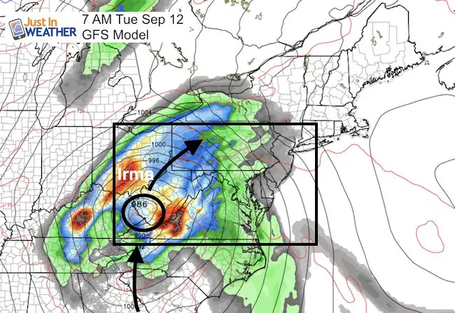
This is the time frame I showed over the weekend with the earlier plots showing an east coast landfall… Now art appears the center of Irma will track north into West Virginia. The potential rain for our region will be Tuesday and Wednesday next week, but in a diminished form
Keep on Trekking
Continue to be part of our Maryland Trek and Support Cool Kids Campaign. This was our best event yet and we want the message to carry throughout the year.
Proceeds go to programs that help children and their families ensuring cancer treatment.

Please share your thoughts, best weather pics/video, or just keep in touch via social media
-
Facebook: Justin Berk, Meteorologist
-
Twitter: @JustinWeather
-
Instagram: justinweather
 Get the award winning Kid Weather App I made with my oldest son and support our love for science, weather, and technology. Our 3 year anniversary of the release and our contribution to STEM education is this November. It has been downloaded in 60 countries, and works in both temperature scales. With your support we can expand on the fun introduction to science and real weather.