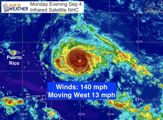
 Monday evening September 4 2017
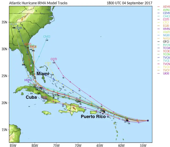
Hurricane Irma has winds of 140 mph making this a very powerful Category 4 storm. The potential for this to intensify over the next two days as it skirts on the north side of the Caribbean Islands. This quick update is to show the general trend for this storm that looks less like Isabel and more that a typical tropical track staying south between Florida and Cuba. The tropical forest model below shows. The outlook beyond next weekend still curves it north, but where is the debate. Please understand that I continue to emphasize that long range forecasting is much less accurate beyond 5 days, and the impact on the US is about a week away.
The Florida Governor has put a State Of Emergency in place. This is to allow for more resources to help should there be a needed evacuation. The storm threat there will be next weekend and then questions arise about a turn north.
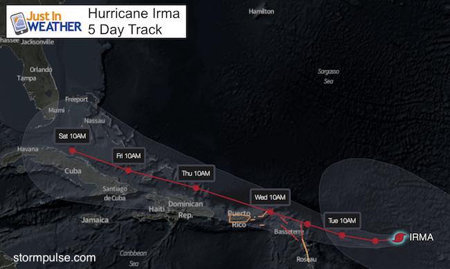
The trend has been for this storm to adjust on the south side of the forecast cone. This results in a slightly slower movement and adjustment later in time with location and interaction with other weather features. Instead of an east coast landfall, the trend is
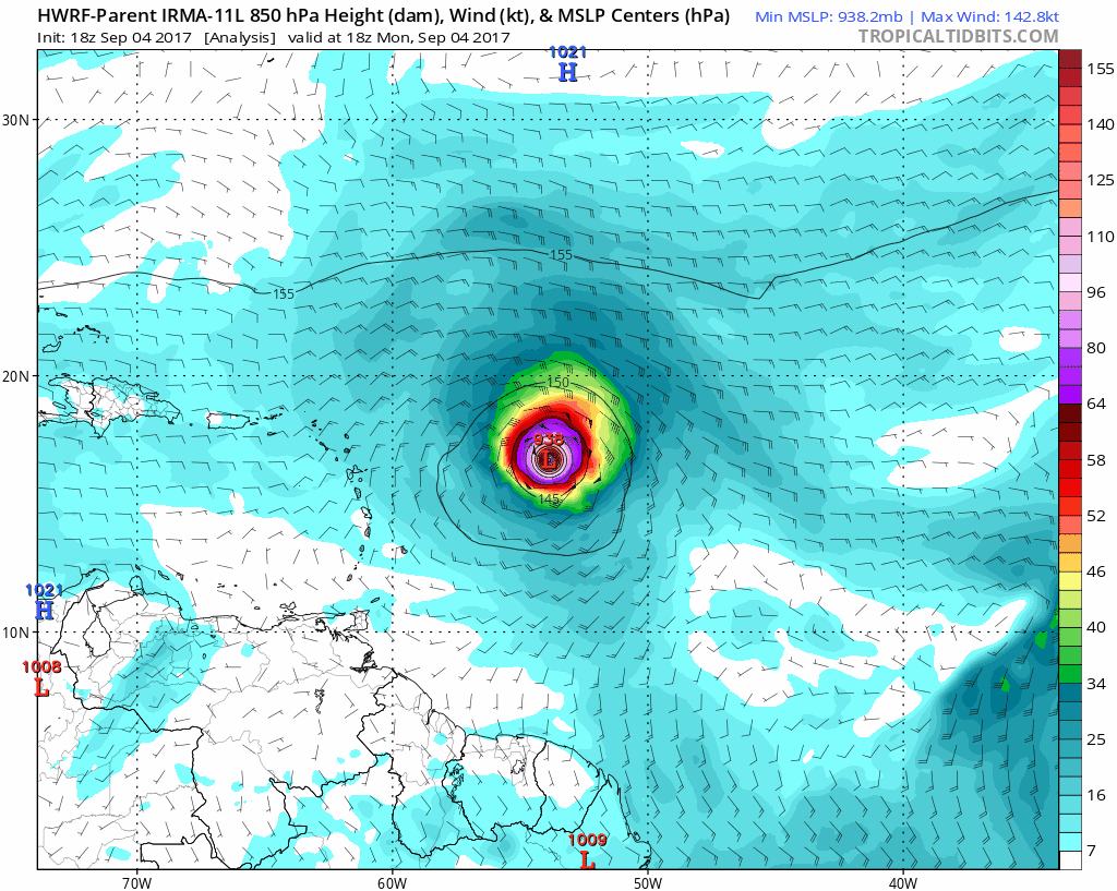
Tropical Model Trend… South Of Miami Next Weekend
This HWRF Model represents the trend of most models with the long range track.
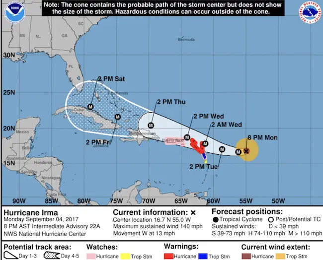
Evening Summary
SUMMARY OF 800 PM AST…0000 UTC…INFORMATION
———————————————-
LOCATION…16.7N 55.0W
ABOUT 450 MI…725 KM E OF THE LEEWARD ISLANDS
MAXIMUM SUSTAINED WINDS…140 MPH…220 KM/H
PRESENT MOVEMENT…W OR 270 DEGREES AT 13 MPH…20 KM/H
MINIMUM CENTRAL PRESSURE…943 MB…27.85 INCHES
SUMMARY OF WATCHES AND WARNINGS IN EFFECT:
A Hurricane Warning is in effect for…
* Antigua, Barbuda, Anguilla, Montserrat, St. Kitts, and Nevis
* Saba, St. Eustatius, and Sint Maarten
* Saint Martin and Saint Barthelemy
A Hurricane Watch is in effect for…
* Guadeloupe
* British Virgin Islands
* U.S. Virgin Islands
* Puerto Rico, Vieques, and Culebra
A Tropical Storm Warning is in effect for…
* Guadeloupe
A Tropical Storm Watch is in effect for…
* Dominica
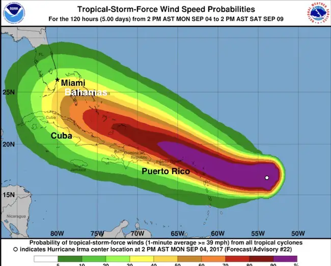
The trend in the tracks beyond Day 5 has been on the south end of the cone… But closer to Cuba then turning north through Florida.
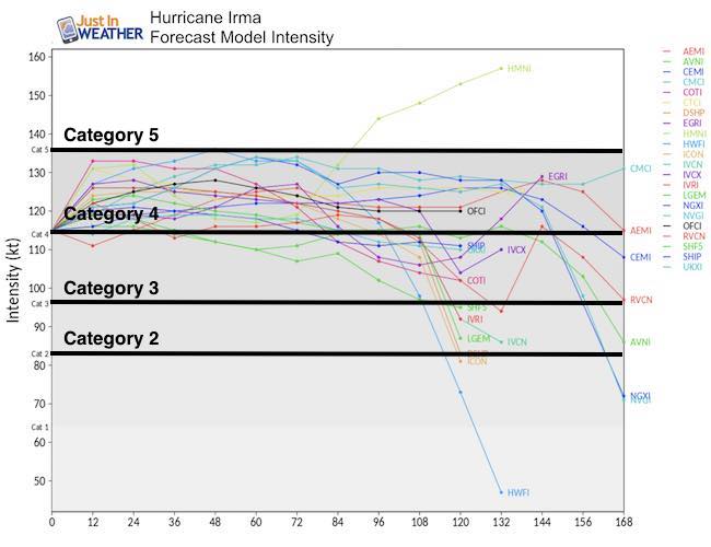
Intensity
Keep on Trekking
Continue to be part of our Maryland Trek and Support Cool Kids Campaign. This was our best event yet and we want the message to carry throughout the year.
Proceeds go to programs that help children and their families ensuring cancer treatment.

Please share your thoughts, best weather pics/video, or just keep in touch via social media
-
Facebook: Justin Berk, Meteorologist
-
Twitter: @JustinWeather
-
Instagram: justinweather
 Get the award winning Kid Weather App I made with my oldest son and support our love for science, weather, and technology. Our 3 year anniversary of the release and our contribution to STEM education is this November. It has been downloaded in 60 countries, and works in both temperature scales. With your support we can expand on the fun introduction to science and real weather.