Winter Storm Wednesday Arrival And Timeline
Tuesday Evening February 19 2019 The weather map this evening is looking very impressive. A large band of rain and snow dominate the eastern half of the nation. It's developing
Tuesday Evening February 19 2019 The weather map this evening is looking very impressive. A large band of rain and snow dominate the eastern half of the nation. It's developing
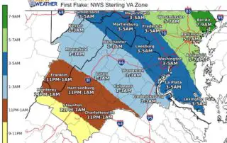
Tuesday February 19 2019 The Winter Strom on the way will be with us Wednesday morning. Most of the are should see the first flakes by daybreak, but here is

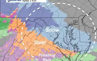
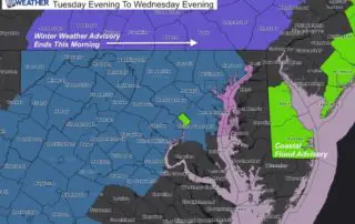
Tuesday February 19 2019 6:30 AM The Winter Storm Warning upgrade for much of central Maryland and Virginia for Wednesday include both moderate snow and heaving icing. A Winter Weather
Monday February 18 2019 This update has a slight adjustment on my snowfall totals. I think it is safe to account for the high intensity snow Wednesday morning, and perhaps
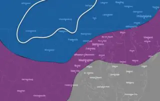
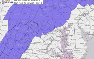
Monday February 18 2019 The Winter Storm Watch now includes all counties west of the Chesapeake Bay and Susquehanna River in our region. The timing across the area varies as
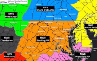
Monday February 18 2019 Have you every seen a weather watch or warning and wondered why your area was not included? Cecil County often feels like they are left out
Monday February 18 2019 The big story is the Winter Storm Watch issued in central Maryland (there will be other areas to follow). The statement has it Tuesday evening to

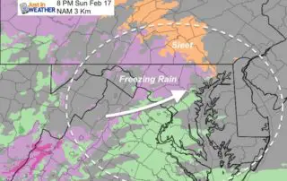
4:30 PM Sun February 17 2019 Doppler Radar appears to be showing the arrival of our wintry weather a little ahead of schedule.The Winter Weather Advisory is still in place
Sunday February 17 2019 Cold air has returned this morning and we will be right on the edge of that air mass as the next system arrives this evening. A
Saturday February 16 2019 The system today is passing to the south with rain and some snow mixed in crossed the very southern edge of Maryland. Meanwhile in the sun,