Monday February 18 2019
The big story is the Winter Storm Watch issued in central Maryland (there will be other areas to follow). The statement has it Tuesday evening to Wednesday evening, but most of us can just plan for the bulk of the action during the daylight hours on Wednesday. This will be a high impact event with a heavy burst of snow followed by sleet and freezing rain. Below is a look at the watch map, snow and ice simulations, and hint at snow potential. But first, we need to talk about the system. departing now.
Temperatures have warmed just enough this morning so that most places under the Winter Weather Advisory should be thawing. A few spots around the Maryland and PA line between Carroll, Baltimore, and York Counties were around 32ºF. Ice was spotty and could take some time to melt. All that is left is some rain moving through southern Maryland and off of the coast. The temperatures will remain in the mid 30s, but the winds will increase making it feel like the 20s today.

Local Weather Stats For February 18, 2019 in Baltimore
Average High: 46ºF
Record High: 75ºF in 1976
Average Low: 27ºF
Record Low: 12ºF in 1958
*Record Snow: 5.7″ in 1964
Sunrise: 6:54 AM
Sunset 5:46 PM
*Daylight = 2:26 longer than yesterday
*Bay Water Temperature = 38ºF at Thomas Pt. Light House
Keep In Touch Every Day
Just in case you don’t get all posts on your social media feed, stay up to date with the latest info…
Click here to sign up for email alerts…. Be the first to hear any new weather.

New Partner
Buchanan Kia of Westminster is a supporter of Just In Power Kids and Maryland Trek 6 in August 2019.
Weather Today
The rain is moving out, but the winds will increase. So temps remain nearly steady but will feel colder with wind chills this afternoon.


Tuesday Temps:
This is to set the stage for preparing the ground for stickage.


Winter Storm Notes:
- Most of our region will see a burst of snow Wednesday morning. This will accumulate a few inches
- School Impact: Yes! I won’t promise, but I expect many schools will cancel even before the first flakes since this will be an all day event.
- How much snow? This depends on your location and timing to change to sleet and freezing rain.
- Ice Storm? I expect a longer period of freezing rain in the same areas that had it last week. There may be more. I will fine turn that over the next day.
- Thursday Impact? We should warm by morning, but ice often lasts longer than computer models show. Especially if there is build up on trees that will be melting and falling on roads.
Winter Storm Watch
- Officially this begins Tuesday Evening in central Maryland and northern VA, but the bulk of snow and ice will arrive Wednesday morning.
- I expect more areas will be added. Please note that our region is split under many NWS Offices that post at different times.
- This map still includes current Winter Weather Advisory in PA and Coastal Flood Advisory in DE

Storm Animation
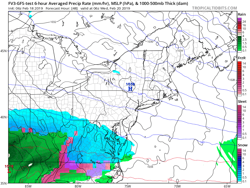
Radar Simulation —> slider
[metaslider id=73453]
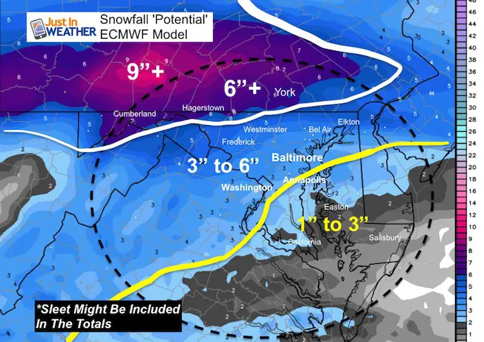
How Much Snow?
- This is just from the ECMWF Model because I am sure you want to have some idea…
- My concern is that there may be some sleet that is being confused and added in with the totals.
- I will have my first call for snowfall map in my afternoon report.
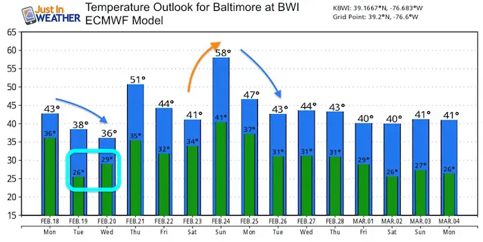
Thursday Morning Temps
There may still be an impact despite the temps above freezing. If we have extensive ice, there will be time needed for it to thaw. Also melt and break or fall off of trees and power lines.

Extended Outlook
Remained that the high temps can be deceiving. The storm on the way will be AFTER the highs on Tuesday and BEFORE the evening highs on Wednesday.
We will have another warm day perhaps with rain next weekend. Then back to near or below average temps again.
Please share your thoughts, best weather pics/video, or just keep in touch via social media
-
Facebook: Justin Berk, Meteorologist
-
Twitter: @JustinWeather
-
Instagram: justinweather
Keep In Touch Every Day
Just in case you don’t get all posts on your social media feed, stay up to date with the latest info…
Click here to sign up for email alerts…. Be the first to hear any new weather.
New Partner
Buchanan Kia of Westminster is a supporter of Just In Power Kids and Maryland Trek 6 in August 2019.
ALL FITF Apparel

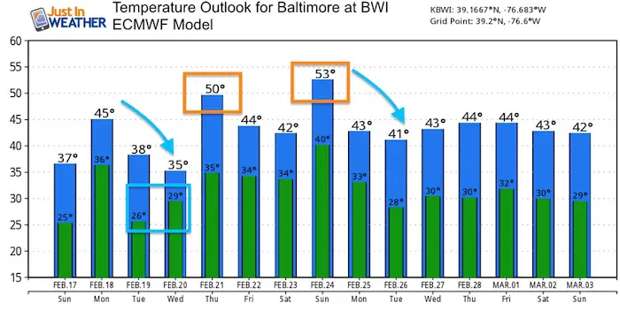
Temperature Outlook
Note: It will be cold enough for snow and ice most of Wednesday in Baltimore. The high temperatures will be at night.
A few warm days will be mixing in with an overall trend near normal.
Please share your thoughts, best weather pics/video, or just keep in touch via social media
-
Facebook: Justin Berk, Meteorologist
-
Twitter: @JustinWeather
-
Instagram: justinweather

New Colors
We are giving 10% of each sale to Just In Power Kids: Providing FREE holistic care for pediatric oncology patients.

Related Links:
Winter Outlook
My Winter Outlook 2018-19: Multiple Nor’Easters and more snow

Interactive Snow Report
November 15 Snow Reports- Interactive Map Compared To My Forecast

Winter Snow And Top 5 Wet Years
Snowfall Seasons at Beginning and End of Top 5 Wet Years In Baltimore

Related Winter Outlooks
Solar Cycle: When Sun Spots Are Low We Get More Snow
El Nino Modoki May Enhance Snow Chances
Sweet Spot: Hitting 70ºF on Halloween is followed by more winter snow
Will A Wet Summer Bring A Snowy Winter?
NOAA Winter 2018-2019 Outlook Explained: This Actually Supports Snow
Winter Outlook From Two Different Farmers Almanacs
Maryland Winters: Snowfall Maps and Baltimore Snow History
