Sunday February 17 2019
Cold air has returned this morning and we will be right on the edge of that air mass as the next system arrives this evening. A Winter Weather Advisory has been issued for some icing from freezing rain. This is for the normally colder areas west and north of Baltimore into southern PA. We should be warming overnight with the freezing line well to our north by Monday morning. So with the Presidents Day Holiday and rising temps, this should not be a Monday morning concern. Come Wednesday, that will be a very different story:
Update: See the NEW Winter Storm Watch Tue Night into Wed Night
Winter Weather Advisory:
The National Weather Service often has a longer time than needed. The model below shows our region warming before the end time stamps. But it is important to remember that any ice that falls can take some time to melt after temps warm. The icing will be light and not like last week’s storm (this time).
- Maryland and Virginia: 3 PM Sunday to 3 AM Monday
- Pennsylvania: 7 PM Sunday to 10 AM Monday

Local Weather Stats For February 17, 2019 in Baltimore
Average High: 45ºF
Record High: 76ºF in 1976
Average Low: 27ºF
Record Low: 12ºF in 1958
*Record Snow: 7.8″ in 1893
Sunrise: 6:55 AM
Sunset 5:45 PM
*Daylight = 2:24 longer than yesterday
*Bay Water Temperature = 38ºF at Thomas Pt. Light House
Keep In Touch Every Day
Just in case you don’t get all posts on your social media feed, stay up to date with the latest info…
Click here to sign up for email alerts…. Be the first to hear any new weather.

New Partner
Buchanan Kia of Westminster is a supporter of Just In Power Kids and Maryland Trek 6 in August 2019.
Morning Temperatures
Cold air this morning Brough the 20s deep into Maryland on both sides of the Bay.

Morning Weather Map
The storm is organizing and wil be part of a very active pattern over the next two weeks. We will be on the edge of the cold air as this arrives this evening.

Freezing Rain and Snow Animation
- The icing locally will be limited this evening and Monday morning. More impact in metro New York to New England with ice and snow.
- This animation ends at 1 PM Monday
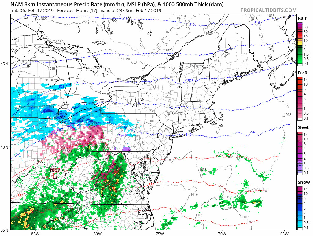
Freezing Rain—> slider
- Warm air at cloud level while colder at the surface is what will develop freezing rain.
- This model shows a limited time and area this freezing rain will fall. The trend has been to push the warmer air in sooner.
- Monday morning should be just wet for most of us, but…
- Since there is potential for some valleys between the airports beings a little colder, it’s possible some spots may hold the ice longer.
[metaslider id=73365]
Temperatures


Monday Morning
Temps will ben just barely above freezing from Westminster to southern PA. Since there is potential for some valleys between the airports beings a little colder, it’s possible some spots may hold the ice longer.

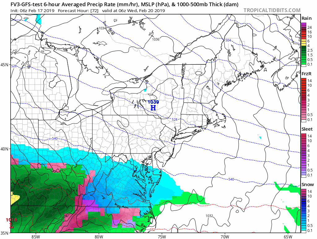
Looking Ahead to Wednesday’s Storm
- Most of our region wil see a burst of snow Wednesday morning as it arrives.
- There will be enough for a few inches to fall before changing over.
- More will fall in areas that will also get more icing along and west of I-95 into Southern PA.
Snow, Ice, Then Rain —> slider
- While there will be a few inches of snow at the onset, it is too early to say how much before the mix and change over. The first indication of snow amounts will be tomorrow (within 48 hours of the event).
- Plan for a change to rain around the Bay and south of The Bay Bridge during the afternoon and evening.
- Ice will be a problem in same areas that had snow and ice last week.
[metaslider id=73392]
ALL FITF Apparel

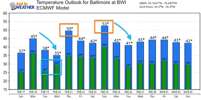
Temperature Outlook
Note: It will be cold enough for snow and ice most of Wednesday in Baltimore. The high temperatures will be at night.
A few warm days will be mixing in with an overall trend near normal.
Please share your thoughts, best weather pics/video, or just keep in touch via social media
-
Facebook: Justin Berk, Meteorologist
-
Twitter: @JustinWeather
-
Instagram: justinweather

New Colors
We are giving 10% of each sale to Just In Power Kids: Providing FREE holistic care for pediatric oncology patients.

Related Links:
Winter Outlook
My Winter Outlook 2018-19: Multiple Nor’Easters and more snow

Interactive Snow Report
November 15 Snow Reports- Interactive Map Compared To My Forecast

Winter Snow And Top 5 Wet Years
Snowfall Seasons at Beginning and End of Top 5 Wet Years In Baltimore

Related Winter Outlooks
Solar Cycle: When Sun Spots Are Low We Get More Snow
El Nino Modoki May Enhance Snow Chances
Sweet Spot: Hitting 70ºF on Halloween is followed by more winter snow
Will A Wet Summer Bring A Snowy Winter?
NOAA Winter 2018-2019 Outlook Explained: This Actually Supports Snow
Winter Outlook From Two Different Farmers Almanacs
Maryland Winters: Snowfall Maps and Baltimore Snow History
