A Break From Summer Heat For A Bit
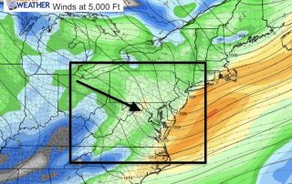
Sunday June 25 We are in a pattern now that flows from Canada. This will drop the humidity but also the temperatures. Today will be noticeably cooler, and the trend

Sunday June 25 We are in a pattern now that flows from Canada. This will drop the humidity but also the temperatures. Today will be noticeably cooler, and the trend
June 24 The ghost of former Tropical Storm Cindy came through on schedule this morning. The radar showed the intense line of rain that looked just like a strong cold

3 PM June 19 The line of severe storms continues to move east with the cold front. Now that we have a distinct line, the short range modeling can do

Saturday June 17 Will it rain or storm by you today? We have started the day with high humidity and warm temps... and we have showers in the forecast. I

Friday June 16 We couldn't hold on to the cooler air for long. The front is on the way back through today and bringing some morning showers with it. A

Thursday June 15 A cool front has pass through shifting our winds from the east. This will keep our temps down, especially along the water where high will be in

Tuesday June 13 Today will be the hottest day of this stretch. Baltimore hit 94ºF on Monday, which was not a record, but Washington DC did set one with a

Saturday June 10 A band of showers in central Pennsylvania this morning will spread clouds into Maryland. But this is al that stands from the heat wave about to develop.

Friday June 9 There is a full moon this morning and many schools have their last day. At least as temperatures warm up, the heat wave is not here yet...

Wednesday June 7 A shift in wind direction is all it takes to change our weather. High Pressure of the Great Lakes helped to bring in an unusually cool air