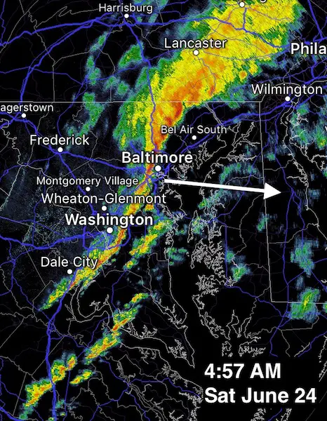
June 24
The ghost of former Tropical Storm Cindy came through on schedule this morning. The radar showed the intense line of rain that looked just like a strong cold front moving through Baltimore around 5 AM. Here is a quick look at the Doppler Radar as it passed by. Now we set the stage for what may appear like an autumn pattern. The humidity with drop and so will the temps. We still have a very high sun angle and shorter nights, so the temperatures we are expecting early next week will be impressive for late June… and quite refreshing.
Doppler Radar of Cindy Passing By Baltimore
—> slider: Cooler Winds
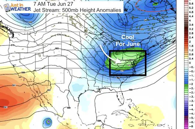
The upper level wind flow shows the cooler air on the way in from the northwest. Temps will rebound to the upper 80s, but the humidity will drop.
[metaslider id=49222]
Jet Stream
Notice not only the cool trough over our region, and the void of above average temps across the nation
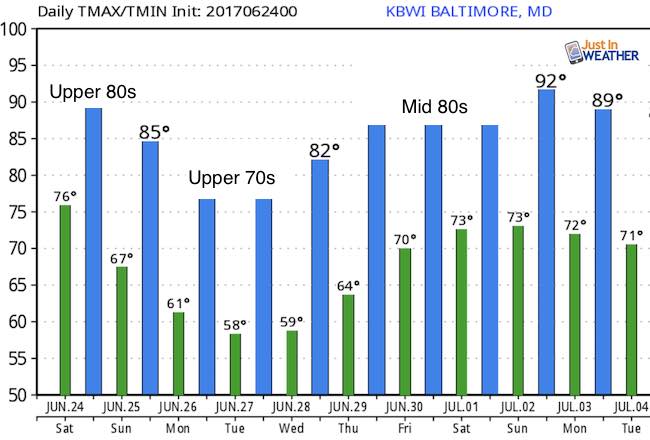
Temperature Outlook
Check it out: Highs in the 70s and lows in the 50s Monday and Tuesday
 Get the award winning Kid Weather App I made with my oldest son and support our love for science, weather, and technology. Our 3 year anniversary of the release and our contribution to STEM education is this November. It has been downloaded in 60 countries, and works in both temperature scales. With your support we can expand on the fun introduction to science and real weather.
Get $1000 Off LASIK
Plus enter to win free sunglasses

Maryland Trek 2017
Be part of my 4th annual hike and bike across Maryland this August. See my trek page and sign up for information to do one day, the whole week, or even sponsor this great event.
Milestones this year:
- I will do my 1000th mile
- We aim to reach $100,000 for Cool Kids Campaign

Please share your thoughts, best weather pics/video, or just keep in touch via social media
-
Facebook: Justin Berk, Meteorologist
-
Twitter: @JustinWeather
-
Instagram: justinweather
Faith in the Flakes
The store is closing for the season. Next week we wil be shifting back to spring mode. This will include a severe weather STEM assembly program.
-
Sign up for email updates on new posts
Since you may miss some posts via social media, click here for email alerts as a way to make sure you don’t miss any. *You may have to refresh that page once for your browser to clear out the images.
Also See: