Irma Track Off East FL Coast: See Amazing Satellite Video
Wednesday September 6 Hurricane Irma has been holding peak winds of 185 mph for nearly a full day. The satellite video below shows the contrast of danger and beauty of

Wednesday September 6 Hurricane Irma has been holding peak winds of 185 mph for nearly a full day. The satellite video below shows the contrast of danger and beauty of

Tuesday September 5 The line of storms charging east has overachieved the afternoon. Numerous warnings have popped up, including a tornado warning in the past hour in northern VA/WV. As
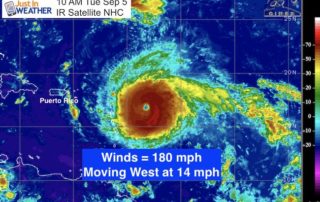
11 AM Tuesday September 5 Hurricane Irma has reached a level that less than 1% of systems achieve. The latest air force reconnaissance shows that this storm has winds of

Monday August 28 The thin veil of clouds in the sky today are thanks to Tropical Storm Harvey way down off of the Texas coast. This water vapor satellite shows

Monday August 28 Tropical Storm Harvey has crawled itself back towards the coast and there is a second system east of Jacksonville that is expected to develop into Tropical Storm
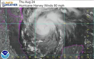
Hurricane Warning As Harvey Could Be Catastrophic. That is not grandstanding, it is reality. This storm has increased to 85 mph winds as of 2 PM EDT since this images
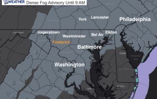
Wednesday August 16 Our weather is improving but you may not notice for a few hours. A Dense Fog Advisory has been issued for our area west of the Chesapeake

Friday August 4 The severe thunderstorm that hit Baltimore County around 5:30 PM Thursday August 3 2017 produce amazing cloud formation and incredible damage. The first image here over Towson
Friday August 4 Much of this week has featured severe weather across central Maryland, but Thursday August 3 it was centered on Baltimore County. The storm that moved through between

Wednesday August 2 Severe storms have erupted early this afternoon as suggested this morning. If you followed my posts online I showed the castleling clouds and then the early pop