 Wednesday September 6
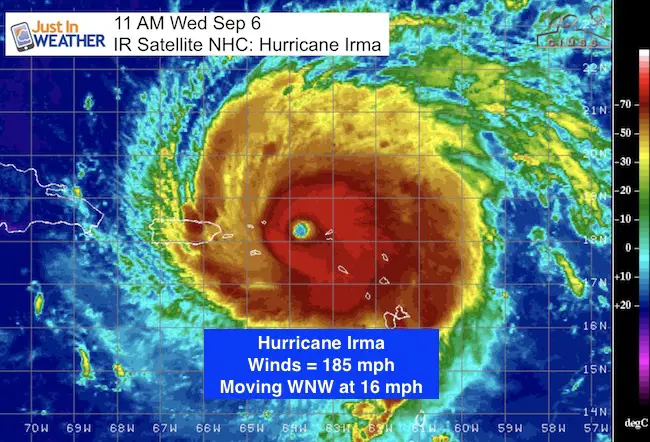
Hurricane Irma has been holding peak winds of 185 mph for nearly a full day. The satellite video below shows the contrast of danger and beauty of this storm along with the stadium effect of the eye from space looking down onto the ocean below. The movement is 16 mph to the west northwest. The worst part of the storm will be north of the Virgin Islands today, with the British portion of that region feeling the strongest winds. This will pass north of Puerto Rico but the edge of hurricane force winds might clip the north side of the island.
Turks, Caicos and Bahamas the next target. This Category 5 mega storm is large in size so the impact will reach wil beyond the track of the eye. Consider that tropical storm force winds reach 185 miles away from the center. That’s a circle of 370 miles. The hurricane force winds reach 50 miles from the center. That brings a 100 mile wind field…
GOES 16 Visible Satellite Video
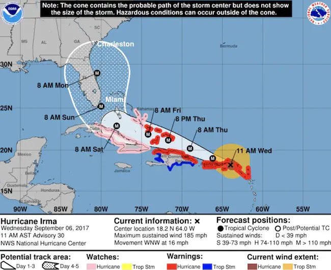
The track approaching land will be important as the right side has the worst impact with wind and storm surge. The path, forward direction, and cold front we have now in the eastern US all play a role in trend where this will go… and now it appears it will turn north on the east side of Florida. If this holds, this is worse for The Bahamas but better for Florida, however the risk to Georgia and South Carolina are a target again. That is back to where the original forecast was. It’s all about timing. See the forecast animation and plots below.

We’ll get back to the forecast plots below, first here are the latest stats and warnings
SUMMARY OF 1100 AM AST
———————————————–
LOCATION…18.2N 64.0W
ABOUT 65 MI…110 KM ESE OF ST. THOMAS
ABOUT 140 MI…225 KM E OF SAN JUAN PUERTO RICO
MAXIMUM SUSTAINED WINDS…185 MPH…295 KM/H
PRESENT MOVEMENT…WNW OR 285 DEGREES AT 16 MPH…26 KM/H
MINIMUM CENTRAL PRESSURE…918 MB…27.11 INCHES
WATCHES AND WARNINGS
A Hurricane Warning has been issued for the north coast of Haiti
from the northern border with the Dominican Republic to Le
Mole St. Nicholas. A Tropical Storm Warning has been issued for
for the coast of Haiti from south of Le Mole St. Nicholas to
Port-Au-Prince.
The government of France has discontinued all warnings for
Guadeloupe.
The government of Antigua has discontinued all warnings for Antigua,
Barbuda, St. Kitts, Nevis, and Montserrat.
SUMMARY OF WATCHES AND WARNINGS IN EFFECT:
This is the National Hurricane Center Forecast Track and Cone Of Uncertainty. Notice the shift to the east of Miami but also a wide cone covering the entire state of Florida.
A Hurricane Warning is in effect for…
* Anguilla
* Saba, St. Eustatius, and Sint Maarten
* Saint Martin and Saint Barthelemy
* British Virgin Islands
* U.S. Virgin Islands
* Puerto Rico, Vieques, and Culebra
* Dominican Republic from Cabo Engano to the northern border with
Haiti
* Haiti from the northern border with the Dominican Republic to Le
Mole St. Nicholas
* Southeastern Bahamas and the Turks and Caicos Islands
A Hurricane Watch is in effect for…
* Cuba from Matanzas province eastward to Guantanamo province
* Central Bahamas
A Tropical Storm Warning is in effect for…
* Dominican Republic from south of Cabo Engano westward to the
southern border with Haiti
* Haiti from south of Le Mole St. Nicholas to Port-Au-Prince
Forecast Trend
Here is the somewhat reliable HWRF Model Animation… Showing the abrupt turn earlier. This is in part due to the faster speed of our mid latitude trough.
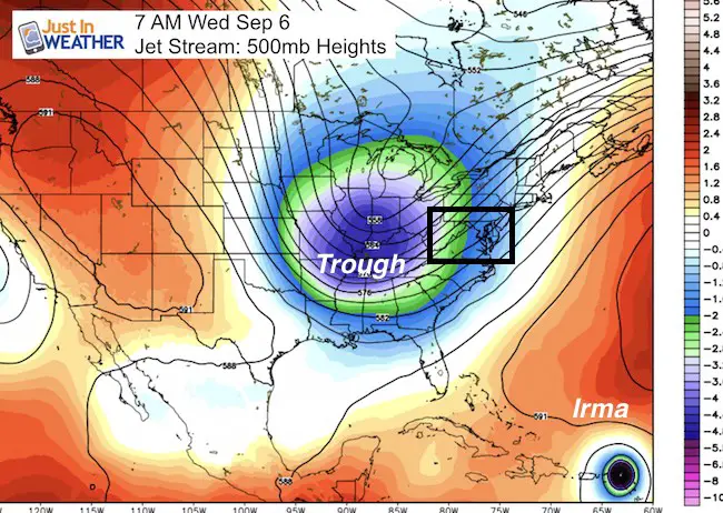
HWRF Forecast
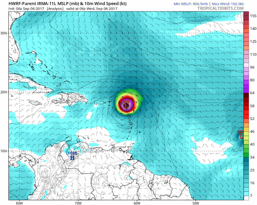
Note: You can See Jose on the edge of your screen. This will curve north into the Atlantic and not be a threat to the east coast US.
Computer Model Tracks
The trend from all models is the shift east of Florida, but the impact on South Carolina near Charleston is a real risk

Model Track Intensity
Some weakening is inevitable as the islands can interfere with some wind flow. Plus the storm can not hold this peak intensity indefinitely. But remaining a Cat 4 is a good chance through the Bahamas and near Florida.

Timing The Onset Of Winds Over 40 mph
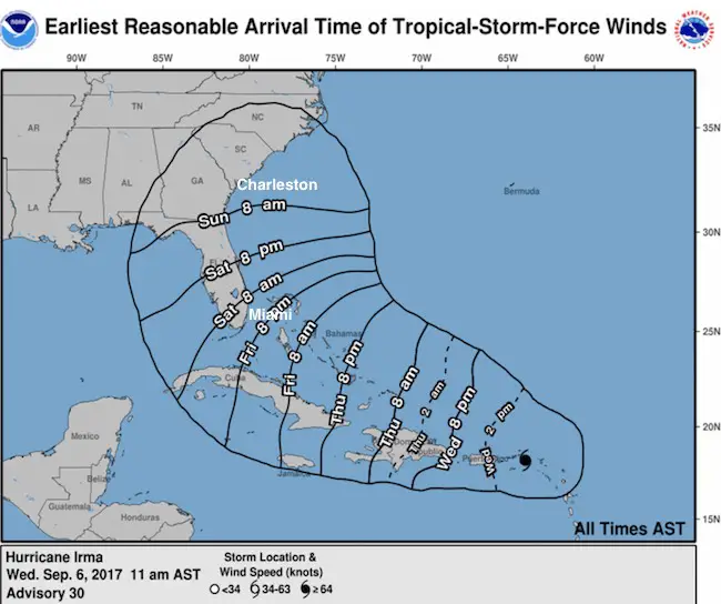

Please note that this is still subject to change as the forward speed and direction can adjust slightly and lead to mid results 5 days away. That is why there is wide cone of possibilities farther out in time.
The threat to the eastern US will be Sunday through Tuesday next week. Once making landfall, the deterioration of the structure will still allow for heavy rain and severe storms for a few days.
Keep on Trekking
Continue to be part of our Maryland Trek and Support Cool Kids Campaign. This was our best event yet and we want the message to carry throughout the year.
Proceeds go to programs that help children and their families ensuring cancer treatment.

Please share your thoughts, best weather pics/video, or just keep in touch via social media
-
Facebook: Justin Berk, Meteorologist
-
Twitter: @JustinWeather
-
Instagram: justinweather
 Get the award winning Kid Weather App I made with my oldest son and support our love for science, weather, and technology. Our 3 year anniversary of the release and our contribution to STEM education is this November. It has been downloaded in 60 countries, and works in both temperature scales. With your support we can expand on the fun introduction to science and real weather.