Monday August 28
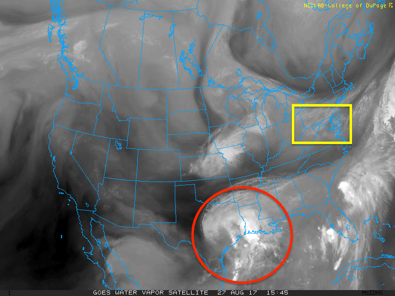
The thin veil of clouds in the sky today are thanks to Tropical Storm Harvey way down off of the Texas coast. This water vapor satellite shows the connection of that system to our region. If it stops, refresh the page to get the loop moving again. The moisture from Harvey could eventually work in our direction, but in the short term it is stuck across the Gulf Coast. A second storm that is expected to be named Tropical Storm Irma should form soon off of the Florida and Georgia coast. Tropical storm force winds could be in parts of Maryland by this time Tuesday.
As of 2 PM the National Hurricane Center is showing winds to 40 mph, but is waiting for the Air Force Reconn mission to confirm the upgrader to Tropical Storm. Until then it is referred to as tropical cyclone ten. I am calling it Irma in this report for simplicity.
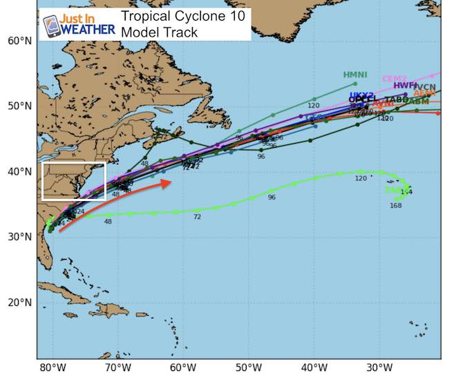
This will move across the Carolinas at a fast clip and out to sea mid week. This will impact our area on Tuesday.
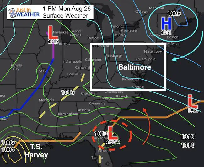
The surface weather map shows strong High Pressure in New England that is helping to increase the easterly winds. That will be the primary reason for gusty and cool winds Tuesday, the pressure gradient between that High and the new tropical system. If only this was winter… but then again the winds will be from the east right off of the ocean. Not the coldest set up, but for late August it keeps us cool.
Tropical Cyclone Ten
Here is the area of concern that appears to be getting better organized this afternoon.
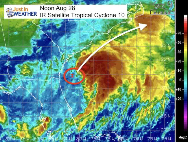
Tropical Storm Irma
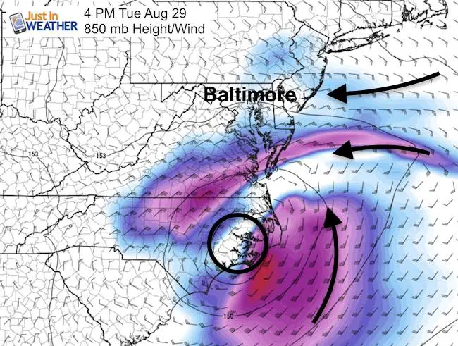
The mid level map shows the strong wind flow Tuesday. The center of circulation for Irma will be passing off of the coast by Duck NC, so not a direct impact. But this will be responsible for the east wind and waves. Thus the warnings and advisories for coastal areas shown below.
Note: There will be steady rain into southern Maryland in direct response to Irma. Showers are likely farther north to Baltimore and maybe York, but that will be thanks to the eastern wind adding in moisture well north of the storm itself.
Rip Currents will linger along the coast through Wednesday and maybe Thursday.
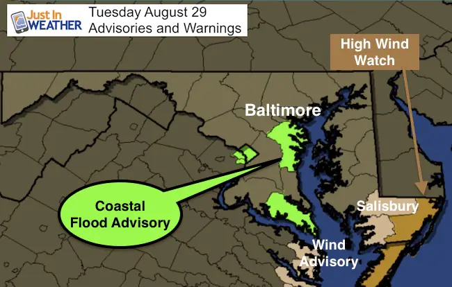
Tuesday: Advisories and Warnings
Wind gusts over 40 mph on the lower Eastern Shore and coastline possible. The coastal flood advisory is for the sloshing on the Chesapeake Bay that will prevent the tide from moving out. This will allow the water to pile on the western shores and up the Potomac River towards Washington.
SUMMARY OF 200 PM EDT…1800 UTC…INFORMATION
———————————————-
LOCATION…31.8N 80.3W
ABOUT 75 MI…115 KM SSW OF CHARLESTON SOUTH CAROLINA
ABOUT 220 MI…355 KM SW OF WILMINGTON NORTH CAROLINA
MAXIMUM SUSTAINED WINDS…40 MPH…65 KM/H
PRESENT MOVEMENT…N OR 010 DEGREES AT 9 MPH…15 KM/H
MINIMUM CENTRAL PRESSURE…1006 MB…29.71 INCHES
WATCHES AND WARNINGS
SUMMARY OF WATCHES AND WARNINGS IN EFFECT:
A Tropical Storm Warning is in effect for…
* North of Surf City to Duck
* Albemarle Sound
* Pamlico Sound
A Tropical Storm Watch is in effect for…
* Surf City to South Santee River
Forecast Track
Keep on Trekking
Continue to be part of our Maryland Trek and Support Cool Kids Campaign. This was our best event yet and we want the message to carry throughout the year.
Proceeds go to programs that help children and their families ensuring cancer treatment.

Please share your thoughts, best weather pics/video, or just keep in touch via social media
-
Facebook: Justin Berk, Meteorologist
-
Twitter: @JustinWeather
-
Instagram: justinweather
 Get the award winning Kid Weather App I made with my oldest son and support our love for science, weather, and technology. Our 3 year anniversary of the release and our contribution to STEM education is this November. It has been downloaded in 60 countries, and works in both temperature scales. With your support we can expand on the fun introduction to science and real weather.