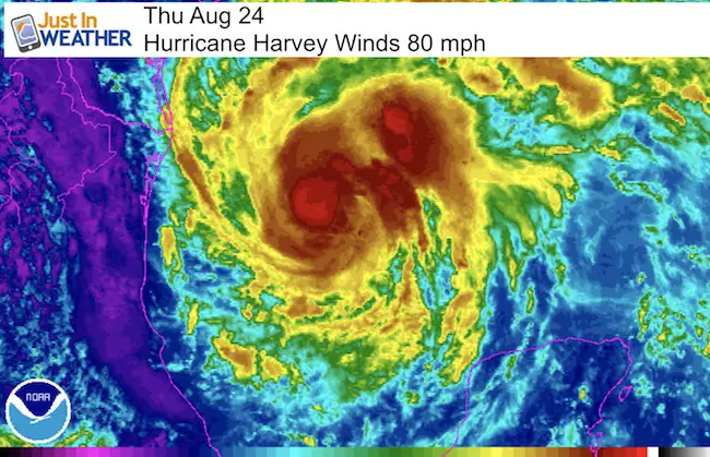
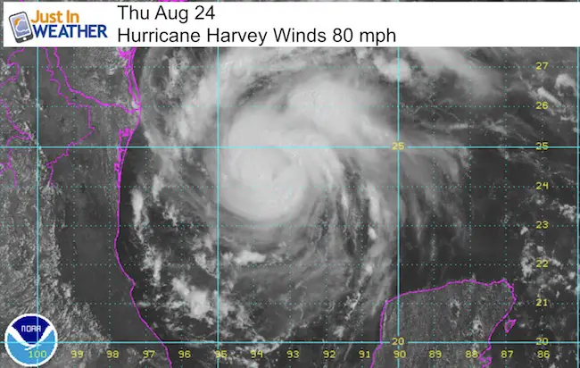
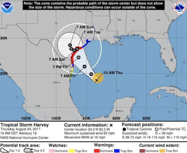
 Hurricane Warning As Harvey Could Be Catastrophic. That is not grandstanding, it is reality. This storm has increased to 85 mph winds as of 2 PM EDT since this images was taken and is strengthening rapidly. It looks healthy with a lot of upside potential. It should become a Category 3 Major Hurricane Friday with winds of 115 mph or higher before making landfall on the central Texas coast. Then most simulations show it slowing to a crawl or stalling.
While landfall may occur overnight Friday into Saturday morning, this will be a long duration event that could rival the $9 Billion damage TS Allison did in 2001. That storm dropped as much as 28 inches in 24 hours over Houston and even a fraction of that could be devastating to coastal areas between Corpus Christi and Houston.
Flooding will come from either of both rain falling and storm surge. Tornadoes will form at landfall as well leading to additional problems to the sustained winds. The highest wind speeds will be confined to a small area around the immediate eye way, but a large region will experience over 75 mph winds.
SUMMARY OF 100 PM CDT…1800 UTC…INFORMATION
———————————————-
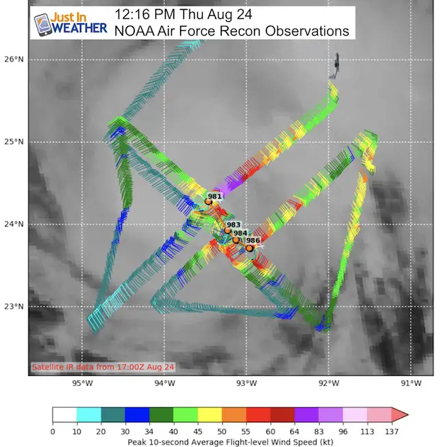
LOCATION…24.4N 93.6W
ABOUT 335 MI…540 KM SE OF CORPUS CHRISTI TEXAS
ABOUT 325 MI…525 KM SSE OF PORT OCONNOR TEXAS
MAXIMUM SUSTAINED WINDS…85 MPH…140 KM/H
PRESENT MOVEMENT…NNW OR 335 DEGREES AT 10 MPH…17 KM/H
MINIMUM CENTRAL PRESSURE…979 MB…28.91 INCHES
Hurricane Reconnaissance flight data around noon
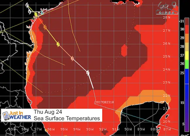
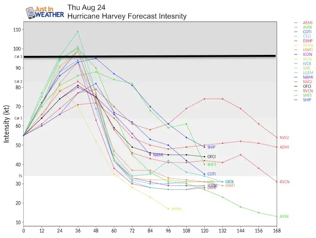
The danger here is that rapid intensification is expected before either making landfall or stalling just off of the central Texas coast Friday night. The latest computer model forecast consensus suggests this will be a major hurricane with winds over 115 mph. Thank to a supportive environment aloft and warm water over 87°F below to allow this to spin up in a hurry.
A major hurricane is bad enough but arriving while in a strengthening is worse. That would bring maximum storm surge and landfall tornadoes.
Forecast Intensity And Tracks
Rapid intensification can often be missed by models. So Wirth a few showing the push above 115 mph, it is very likely at this point it will happen and the other models will eventually catch up. That said, I have seen this set up too many times when the growth exceeds expectations so the upside potential is big!
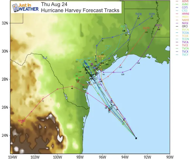
Tracks
The 144 hour forecasts translate to 6 days away… and notice the cluster remaining in the same vicinity.
National Hurricane Center Map
Flooding
Freshwater Flooding From Rain
The slow movement means predicted 15″+ rainfall could easily be double or triple that amount.
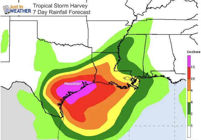
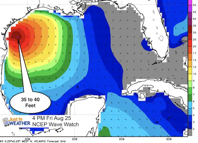
Saltwater Flooding From Storm Surge
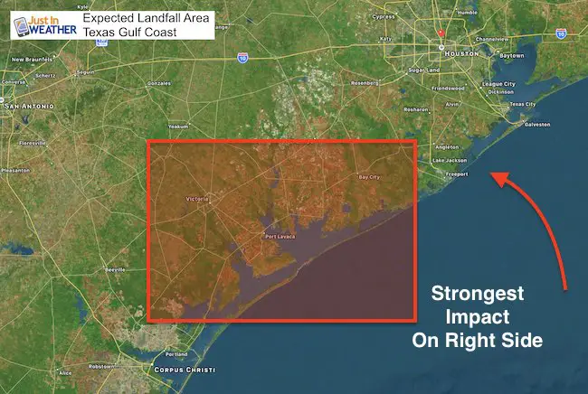
Waves around the center eye wall could reach 40 Ft, while the momentum of the storm moving onshore itself will push water on to the coast… especially on the northeast or right side of the eye.
Long range models suggest a cold front could pick this up and bring rain across the south and Mid Atlantic next week, but that is subjective based on where the core of Harvey meanders.
WATCHES AND WARNINGS
——————–
CHANGES WITH THIS ADVISORY:
The Storm Surge Warning has been extended northeast of San Luis
Pass to High Island Texas.
SUMMARY OF WATCHES AND WARNINGS IN EFFECT:
A Storm Surge Warning is in effect for…
* Port Mansfield to High Island Texas
A Storm Surge Watch is in effect for…
* South of Port Mansfield Texas to the Mouth of the Rio Grande
A Hurricane Warning is in effect for…
* Port Mansfield to Matagorda Texas
A Tropical Storm Warning is in effect for…
* North of Matagorda to High Island Texas
* South of Port Mansfield Texas to the Mouth of the Rio Grande
A Hurricane Watch is in effect for…
* South of Port Mansfield Texas to the Mouth of the Rio Grande
A Tropical Storm Watch is in effect for…
* South of the Mouth of the Rio Grande to Boca de Catan Mexico
A Storm Surge Warning means there is a danger of life-threatening
inundation, from rising water moving inland from the coastline,
during the next 36 hours in the indicated locations. For a
depiction of areas at risk, please see the National Weather
Service Storm Surge Watch/Warning Graphic, available at
hurricanes.gov. This is a life-threatening situation. Persons
located within these areas should take all necessary actions to
protect life and property from rising water and the potential for
other dangerous conditions. Promptly follow evacuation and other
instructions from local officials.
A Hurricane Warning means that hurricane conditions are expected
somewhere within the warning area. A warning is typically issued
36 hours before the anticipated first occurrence of tropical-storm-
force winds, conditions that make outside preparations difficult or
dangerous. Preparations to protect life and property should be
rushed to completion.
A Tropical Storm Warning means that tropical storm conditions are
expected somewhere within the warning area within 36 hours.
A Storm Surge Watch means there is a possibility of life-
threatening inundation, from rising water moving inland from the
coastline, in the indicated locations during the next 48 hours.
A Hurricane Watch means that hurricane conditions are possible
within the watch area.
A Tropical Storm Watch means that tropical storm conditions are
possible within the watch area.
Please share your thoughts, best weather pics/video, or just keep in touch via social media
-
Facebook: Justin Berk, Meteorologist
-
Twitter: @JustinWeather
-
Instagram: justinweather
 Get the award winning Kid Weather App I made with my oldest son and support our love for science, weather, and technology. Our 3 year anniversary of the release and our contribution to STEM education is this November. It has been downloaded in 60 countries, and works in both temperature scales. With your support we can expand on the fun introduction to science and real weather.

Wear our cool cycle jersey from Hill Killer
Click the image…