Friday August 25
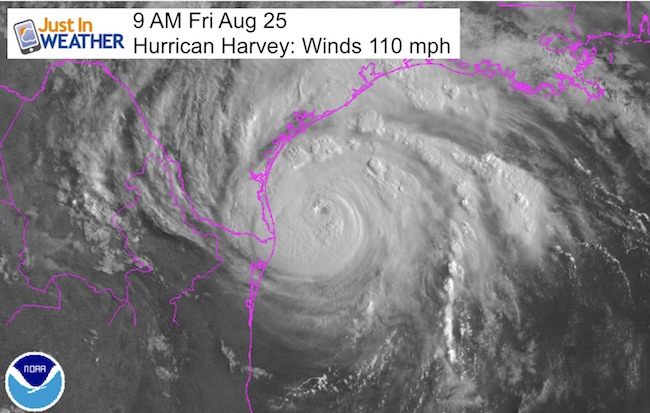
Hurricane Harvey winds were measured at 110 mph, open the upper edge of the Category 2 status. Once over 111 mph winds , it is considered a Category 3 and a major hurricane. The damage can be catastrophic, and that is what Texas is expecting. It is been 12 years since the last time a major hurricane has made landfall in the US. It was October 24, 2005 when Wilma hit southwest Florida. That was after the record tropical season and this was at one time a Category 5.
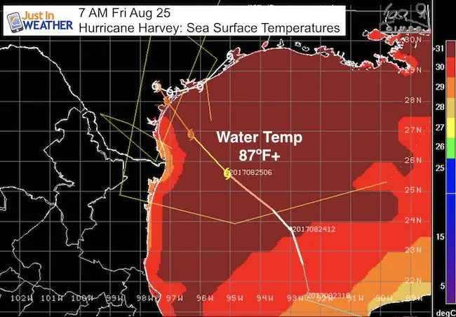
This storm will continue to strengthen today as it is moving over very warm water 87ºF or higher. This will almost promise this reaches wind of 125 mph or higher.
For east central Texas, it has been 47 years since their last major hurricane, so the build up of infrastructure will be tested to its limit. The impact will include:
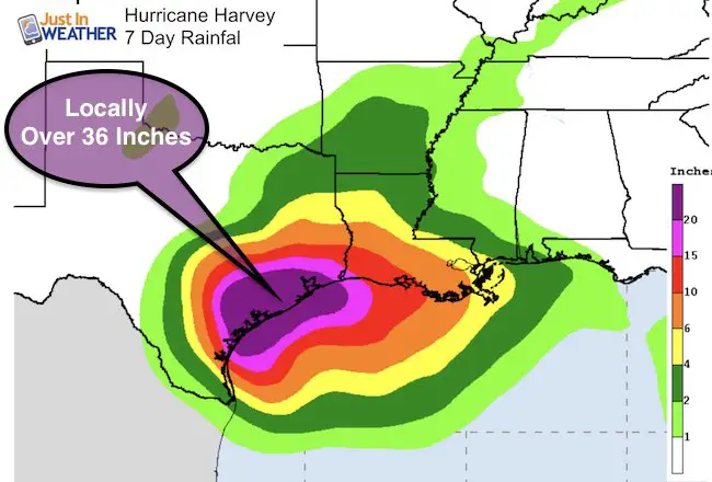
Flooding both from a storm surge over 12 feet and rainfall over 36 inches in spots over the next week. Most places near landfall and the east side will see at least 12 inches of rain.
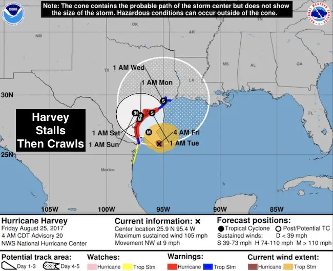
Wind damage will come from the peak winds right along the eye wall that is a very small area near and just east of the center at landfall. There will also be tornadoes that spin up away from the center for days following landfall as this storm will stall and crawl.
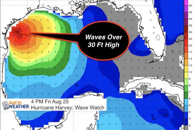
Waves
Waves jut offshore will be 30 Feet High. This is NOT the storm surge but will feed into it
Rainfall
SUMMARY OF 700 AM CDT…1200 UTC…INFORMATION
———————————————-
LOCATION…26.3N 95.8W
ABOUT 140 MI…225 KM SE OF CORPUS CHRISTI TEXAS
ABOUT 145 MI…235 KM SSE OF PORT OCONNOR TEXAS
MAXIMUM SUSTAINED WINDS…110 MPH…175 KM/H
PRESENT MOVEMENT…NW OR 315 DEGREES AT 10 MPH…17 KM/H
MINIMUM CENTRAL PRESSURE…950 MB…28.05 INCHES
Forecast Map: Stall and Crawl
The storm will slow down and then expected to drift to the Northeast.. which could impact Louisiana more into next week
WATCHES AND WARNINGS
——————–
CHANGES WITH THIS ADVISORY:
SUMMARY OF WATCHES AND WARNINGS IN EFFECT:
A Storm Surge Warning is in effect for…
* Port Mansfield to High Island Texas
A Storm Surge Watch is in effect for…
* South of Port Mansfield Texas to the Mouth of the Rio Grande
A Hurricane Warning is in effect for…
* Port Mansfield to Sargent Texas
A Tropical Storm Warning is in effect for…
* North of Sargent to High Island Texas
* South of Port Mansfield Texas to the Mouth of the Rio Grande
A Hurricane Watch is in effect for…
* South of Port Mansfield Texas to the Mouth of the Rio Grande
A Tropical Storm Watch is in effect for…
* South of the Mouth of the Rio Grande to Boca de Catan Mexico
Another system to watch
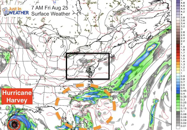
While Harvey hits Texas, there will be anther storm trying to form off of the southeast coast. This is likely to stay offshore, but could throw rain our way and strong waves for our local beaches next week.
—-> slider
[metaslider id=51419]
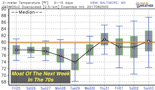
Temperature Outlook
Please share your thoughts, best weather pics/video, or just keep in touch via social media
-
Facebook: Justin Berk, Meteorologist
-
Twitter: @JustinWeather
-
Instagram: justinweather
 Get the award winning Kid Weather App I made with my oldest son and support our love for science, weather, and technology. Our 3 year anniversary of the release and our contribution to STEM education is this November. It has been downloaded in 60 countries, and works in both temperature scales. With your support we can expand on the fun introduction to science and real weather.

Wear our cool cycle jersey from Hill Killer
Click the image…