October 5 Dense Fog Advisory Then Tracking More Showers Later
Tuesday October 5 A few rounds of showers and thunderstorms passed through parts of central Maryland late yesterday and into the evening. The added moisture has helped developed thick fog

Tuesday October 5 A few rounds of showers and thunderstorms passed through parts of central Maryland late yesterday and into the evening. The added moisture has helped developed thick fog

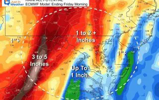
Wednesday September 22 Heavy rain is on the way. We’ve already discussed that, and perhaps you have already had one of those heavy showers move by your place. The Flash
Tuesday September 21 2021 A Flash Flood Watch has been issued for western Maryland from Frederick to Garrett County, and the mountains of Virginia and WV. I want to first
Wednesday September 8 2021 The advertised cold front is still on the way. It has just taken its time, meaning it will take longer to move out as well. In
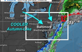
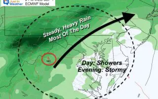
Thursday September 2 2021 The remains of former Hurricane Ida will be exiting New England this morning. The swath of heavy rainfall, flooding, and tornado damage has been historic. Today
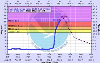
Thursday September 2 Following the historic rainfall on Wednesday, we continue to monitor the water that flows down rivers. This report is focusing on The Monocacy River in Frederick County
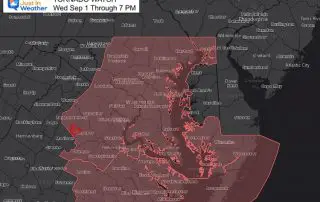
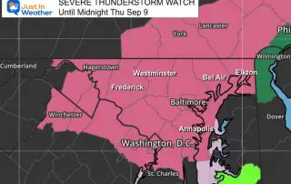
Wednesday September 1 Noon Update A Tornado Watch has been issued for our region this afternoon and evening. This is in response to the remains of former Hurricane Ida passing

Wednesday September 1 The morning began with a Tornado Watch, Severe Thunderstorm Warning, and Flood Warnings. That was before 5 AM and included the big cities. Today is going to
Tuesday Afternoon August 31 What we are calling Ida is no longer a tropical system and not being tracked by The National Hurricane Center. However, it was once a high

Monday Evening August 30 The thunderstorms we had today were separate from the main event on the way. This is a focus on Depression Ida, which has been downgraded with