Winter Storm Watch: First snow maps and timeline this weekend
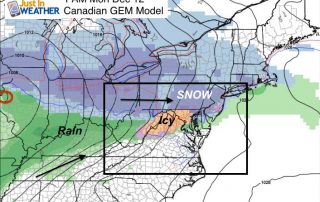
Thursday December 15 - A Winter Storm Watch has been issued for Friday night through Saturday morning. This is for minor snow accumulation plus ice before a change over to

Thursday December 15 - A Winter Storm Watch has been issued for Friday night through Saturday morning. This is for minor snow accumulation plus ice before a change over to

Thursday December 15 - Today will be an opposite day of sorts. The winds will pick up as the temperatures drop down. A Wind Advisory has been issued for today

Wednesday December 14 - The arctic blast that has been advertised for many days is about to arrive. While there is not much moisture now, there is an upper level

Wednesday December 14 - The leading edge of the really cold arctic air is on the way. The Polar Vortex to our north will spill in overnight with a chance

Tuesday December 13 - The infamous Polar Vortex will be skirting northern New England, sending the first true blast of arctic air our way Thursday and Friday. Highs both days

Tuesday December 13 - The next round of arctic air is about to move in this week with the Polar Vortex clipping northern Maine. The set up will allow an

Monday December 12 - The icy threat overnight quickly went to rain as strong winds aloft pushed in warmer air and rain. This band of rain will cross the Eastern

Sunday December 11 - Flurries have arrive. The radar shows it and the atmosphere finally supported the flakes falling and reaching the ground this morning. We have a stickage and

Saturday December 10 - The core of the cold air settles in today as temperature will remain in the 30s. The winds will not be as strong, and more clouds
Friday December 9 - You will feel it for sure as you step outside this morning. At 6 AM Baltimore's BWI was down to 28°F with a wind chill of