Storm Tuesday Morning Marginal Severe Risk Then Colder Wednesday
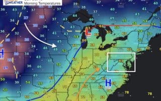
Monday October 23 The storm in Kentucky and the strong cold front draped into Georgia today will be moving east and could bring some showers this evening. There will be
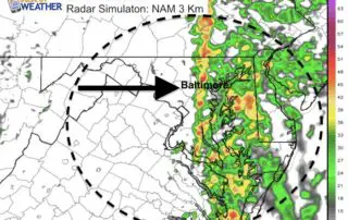
Monday October 23 The storm in Kentucky and the strong cold front draped into Georgia today will be moving east and could bring some showers this evening. There will be

Monday October 16 After a weekend with temps in the 70s, a little bit of rain marks the cool down on this Monday. The rain will slip south and mostly
Sunday October 15 Yet another warm and muggy morning with areas of fog. The temperatures are still in the territory of where we should be for afternoon highs... but before

Saturday October 14 Category 2 Hurricane Ophelia still has 100 mph winds and is now racing through into the eastern Atlantic towards Ireland. The visible satellite from sunrise over the

Thursday October 12 It is going to feel a little more like Fall today. One band of overnight rain is moving east, but the overall wind pattern from the east

Wednesday October 11 Just getting back to near normal weather is a big news. After two days with record warm low temps and nearly a month without rain, we finally

8 AM Monday October 9 The heaviest of the rain is now on our region. The remains of Nate are passing to our northwest keeping us on the warm and

Sunday October 8 Tropical Depression Nate has winds of 35 mph and is racing to the north at 23 mph. This was expected to be downgraded at this point, and

Sunday October 8 Nate made landfall last night as a hurricane but got knocked down to 45 mph winds and a tropical storm today. The forward speed of 25 mph

8 AM Sat Oct 7 Hurricane Nate intensified last night and continues to grow stronger in the Gulf of Mexico. The reason it is stronger that expected is because it