 Sunday October 15
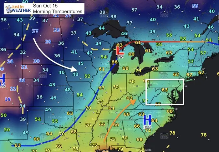
Yet another warm and muggy morning with areas of fog. The temperatures are still in the territory of where we should be for afternoon highs… but before sunrise. There is plenty of cold air to be seen on the weather map and it will be moving in behind a cold front overnight. It’s almost funny that the main debate could possibly be no as warm. The forecast maps in the min-slider show that both the high resolution HRRR Model and NAM 3Km show lower 70s, while the GFS Model has us into the lower 80s. All mean a warm and dry day at the Ravens game and above normal. See today’s stats to compare below. The rain for most of us should hold off until Monday morning.
Temperature Forecast —> Mini-Slider
How warm will depend in part to how much sun can break through the low clouds.
[metaslider id=53957]
Stats For October 15
Normal High: 67ºF
Record High: 86ºF in 1989
Normal Low: 46ºF
Record Low: 32ºF in 2006
Sunrise: 7:17 AM
Sunset 6:28 PM
Rain Timeline
The cold front that will end this heat will show up as a dusting line of showers and maybe a T’Storm in the mountains this evening. However, it will fall apart pushing east tonight. By midnight the line will be hardly noticeable and the line will stall over our region. The slider below shows the rain Monday morning that will slowly move through and bring us the cooler Monday.
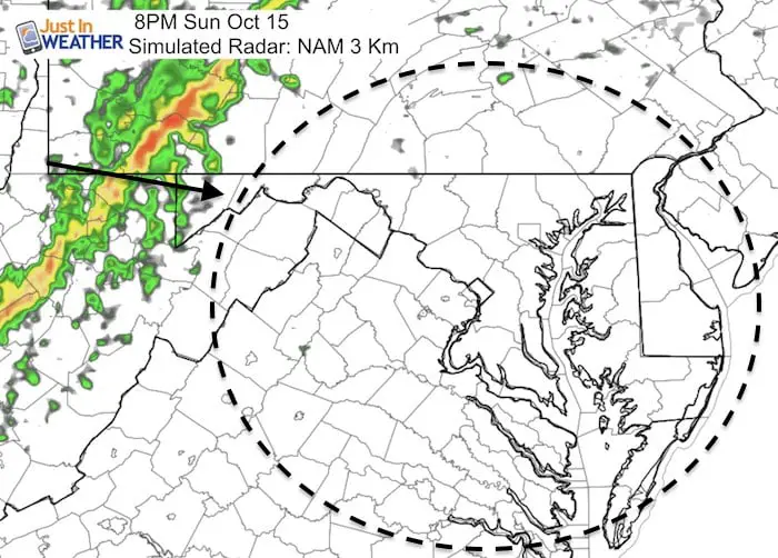
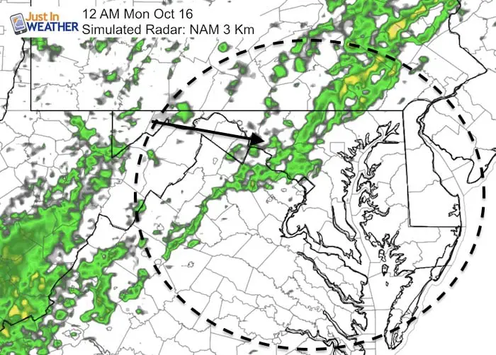
—-> Slider: Simulated Radar- Monday Morning Rain
[metaslider id=53942]
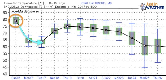
Temperature Outlook
We still can’t seem to hold the cold very long. Another warm up for the week ahead. There is a hint of the next cool down after next Sunday. Personally I believe this extended warm spell will trade off with a below normal pattern just in time for winter. Patience fellow snow lovers. FITF
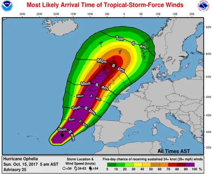
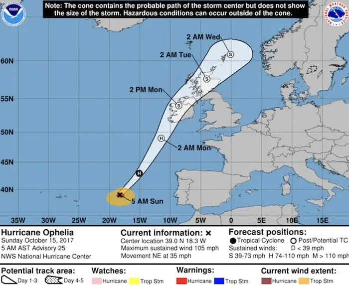
Hurricane Ophelia
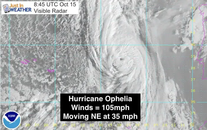
This is one very impressive little and strange storm. This briefly read 115 mph winds Saturday night and was a Category 2. This morning the winds are back down to 105 mph and it is now racing at 35 mph into colder water on the way to Ireland and Scotland. The storm may transition to a post tropical system but remain with winds close to 75 mph when making landfall Monday. The main issues will be 2 to 4 inches of rain and a storm surge on the coast. The good news is that it will be a quick mover.
Storm Animation
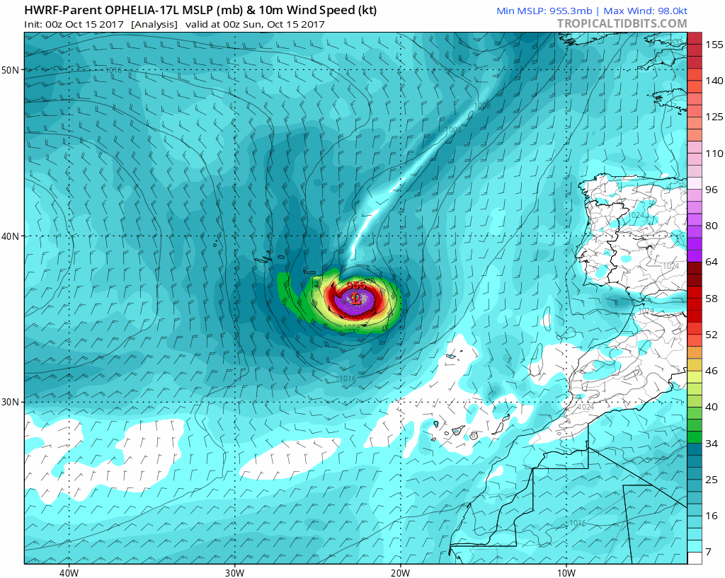
The Tropical Storm Conditions will reach Ireland by Monday morning. The storm is small but has expanded a little. It has hurricane force winds reaching 45 miles out from the center. Tropical Storm force winds are larger 150 miles away.
 Get the award winning Kid Weather App I made with my oldest son and support our love for science, weather, and technology. Our 3 year anniversary of the release and our contribution to STEM education is this November. It has been downloaded in 60 countries, and works in both temperature scales. With your support we can expand on the fun introduction to science and real weather.
Forecast Track
Trust in this Bust- Limited Edition Shirt
This is not a forecast, but a fundraiser for breast cancer research at BCRF- the highest rated cancer research charity. This soft Bella T-Shirt is to promote the strength of the ‘good bust’ and the heart that beats strong beneath it. Proceeds will be donated in honor of my mother Linda Berk, a 3-time breast cancer survivor. Click on the shirt image to join us.

Please share your thoughts, best weather pics/video, or just keep in touch via social media
-
Facebook: Justin Berk, Meteorologist
-
Twitter: @JustinWeather
-
Instagram: justinweather