Mary 23 Weather Brings Enhanced Severe Storm Risk For Our Region
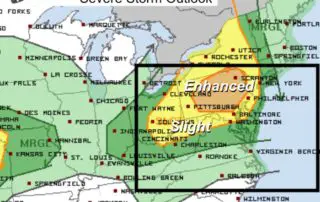
Thursday May 23 2019 Today is our day to pay close attention to developing weather. The Storm Prediction Center has much of Pennsylvania and central Maryland in the Enhanced Risk

Thursday May 23 2019 Today is our day to pay close attention to developing weather. The Storm Prediction Center has much of Pennsylvania and central Maryland in the Enhanced Risk
Wednesday May 22 2019 This morning is cool and crisp under a clear sky. Many stations are reporting the mid 40s to near 50ºF at sunrise. We will have another

Tuesday May 21 2019 Baltimore reported the first day above 90 degrees on Monday. It was 91ºF at BWI, but our weather will be cooler and quiet for a few

Monday May 20 2019 The storms on Sunday tracked from Hagerstown to Southern PA. Today, a cold front will help to bring a round of thunderstorms to central Maryland mid

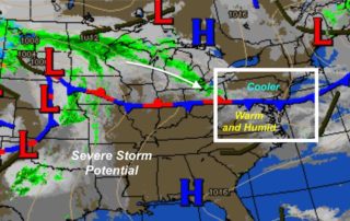
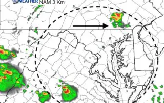
4 PM Sunday May 19 2019 We definitely got the heat this afternoon and we have a few boundaries to watch for where storms may develop and travel. Here is
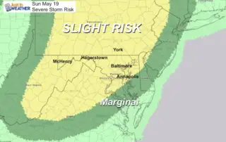
Sunday May 19 2019 Today's weather brings some in Maryland to the 90ºF mark and a round of potentially severe thunderstorms. It is important to keep the set up in
Saturday May 18 2019 We broke our streak of consecutive Fridays with rain at 15. Now we are about to break the cool and wet spring and jump into summer.
Friday May 17 2019 We are about to change the trend. It may seem like we should have rain just because it is Friday, and there will be some. But

Thursday May 16 2019 Rain has already been rolling across our region this morning. This will be easing mid day, but some more showers or even a thunderstorm could pop

Tuesday May 14 2019 Just when you thought it was chilly here, snow is falling this morning in northern New York and New England. This is a bit extreme for