Sunday May 19 2019
Today’s weather brings some in Maryland to the 90ºF mark and a round of potentially severe thunderstorms. It is important to keep the set up in mind as it may repeat later this week, with more heat and stronger storms.
Severe storms did reach central Maryland on Saturday with pockets of hail and heavy rain. Across the nation, this has been the most active four day with tornados this year. The entire week will be busy, and we have two windows of time to get in on it. Today will be one, the other will be the end of the work week.
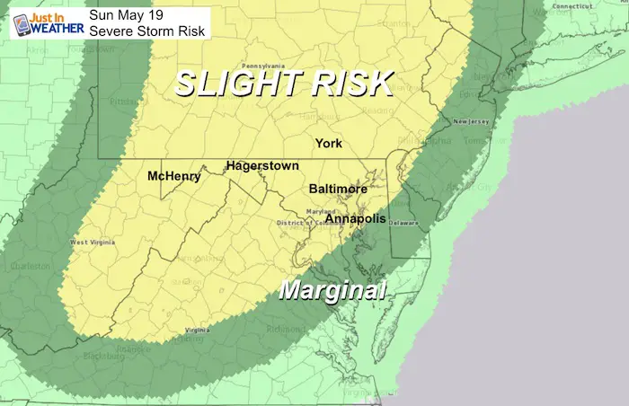
Severe Storm Today:
The timing will be late afternoon through sunset. The risk:
- Winds over 58 mph
- Large hail over 1 inch diameter (size of a quarter)
- Isolated tornados
- Frequent dangerous lightning
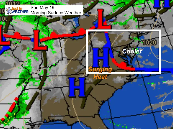
Morning Weather Map
A front is till draped across our state. This will determine who gets into the 90s or stays in the 80s. Often on the northern edge of the heat is where the strong pulse of storms will ride.
Radar Simulation Timeline –> slider
[metaslider id=76680]
Local Weather Stats For May 19, 2019 in Baltimore
Average High: 75ºF
Record High: 98ºF in 1962
*Tied for hottest ever for the month
Average Low: 53ºF
Record Low: 38ºF in 2009
Sunrise: 5:49 AM
Sunset 8:16 PM
*Daylight = 1:41 longer than yesterday
*Bay Water Temperature = 65ºF at Thomas Pt. Light House
Weather Forecast Below
Keep In Touch Every Day
Just in case you don’t get all posts on your social media feed, stay up to date with the latest info…
Click here to sign up for email alerts…. Be the first to hear any new weather.
Maryland Trek 6
Our look got an upgrade, but we have the same purpose. Please click the logo take a look at our new page.
- Consider joining our team for the week, a single day, or even as a sponsor.

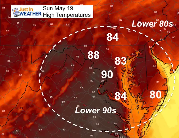
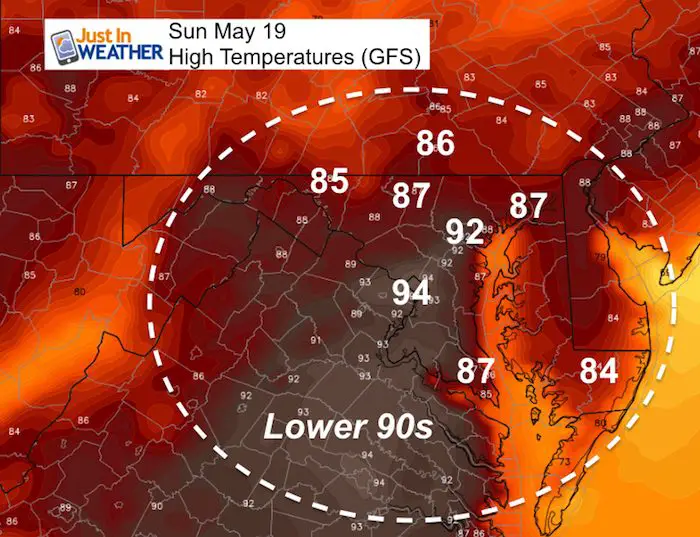
Temperatures
Today
Will 90ºF reach Washington. How about Baltimore?
This NAM 3Km Model shows a stark difference between the two cities less than 40 miles apart.
The GFS Model has the front move east and gets Baltimore into the warmer air.
Yes, the forecast has a 9 degree difference for the city. It really depends on where the front sets up, which may also determine where the storms play out as well.
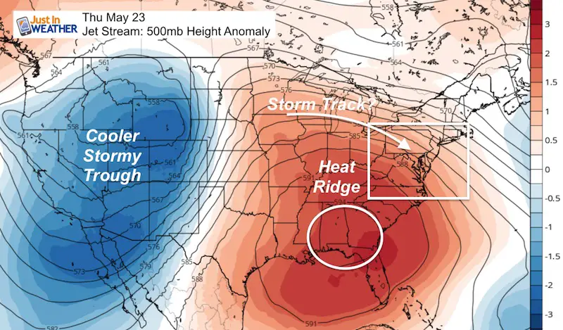
Looking Ahead
A large heat dome will develop across the southeastern US. The location and size of this will determine if ewe get in on to or remain on the edge like this weekend’s temps. That could make the difference between getting into the 90s or staying in the 80s with a greater risk of storms.
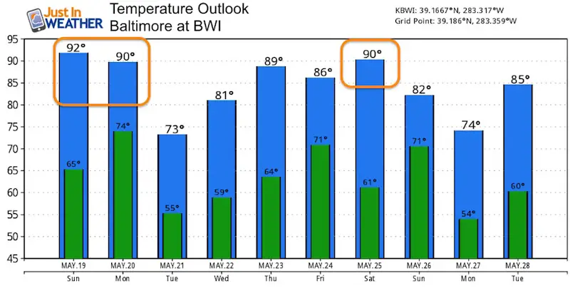
Temperature Outlook
I have had some people remark how different the outlook has been almost each day. This all depends on the heat dome/ridge to our south. Either we get in on it, which history suggests. Or we stay on the northern edge with more risk of storms like this weekend’s set up. I am leaning towards the heat, so these numbers could easily be higher than shown here now.
Support Our Nonprofit:
Proceeds go to our programs Providing FREE holistic care for kids in cancer treatment and up to 5 years post treatment and caregivers.
![]()
Shine On
Proceeds from all sales go to Just In Power Kids. Click the image to shop and show your support.

Love Maryland Shirts and Hoodies
This shirt was designed by my ‘bonus’ daughter Jaiden. The hoodie has been the biggest hit, so our promotion has been extended until the end of this week.
|
||
|
Show your love for Maryland and make this 14 year old artist and her mom extra proud
|


Please share your thoughts, best weather pics/video, or just keep in touch via social media
-
Facebook: Justin Berk, Meteorologist
-
Twitter: @JustinWeather
-
Instagram: justinweather
Related Links:
Was Your County Not Included?
Click this map for more on the regional forecast zones
