Frigid Friday And Update On Some Snow
Thursday December 8 - The cold front has moved through and the colder air will be noticeable Friday morning. Temperatures will drop into the 20s and with winds up to
Thursday December 8 - The cold front has moved through and the colder air will be noticeable Friday morning. Temperatures will drop into the 20s and with winds up to
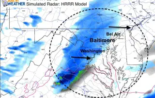
Thursday December 8 - A disturbance is moving through ahead of the arctic air. There is a band of flurries and sprinkles this morning, but warmer air will build from
Sunday November 20 - The monster cold front we had yesterday meant business and today you will feel the cold winds for sure. Baltimore's BWI went from a high of

Saturday November 19 - A strong cold front is on the way that will mark a significant pattern change. Baltimore hit 73°F on Friday which was not a record but

Friday February 26- Today is picking up where yesterday left off. Strong winds and some flurries, most of which are confined north and west of Baltimore. But don't be surprised

February 18 6 AM Update: Winds pick up as temperatures crash back down this morning. The roller coaster ride continues when you consider the snow and ice have melted but

February 13 - We are in the midst of our coldest days of the season, and still have a Wind Chill Advisory through Sunday. But we must look just past

February 13 - If you have not heard the term Polar Vortex (again) this week, it's back. The core of the coldest air in the Northern Hemisphere is diving towards New
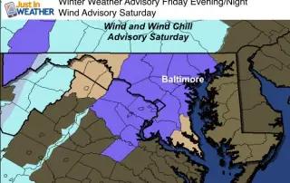
February 12- Update to try and simplify the advisories. Winter Weather Advisory (purple shade): Central Maryland and northern Virginia this afternoon through midnight. General dusting to 1 inch of snow. Some
February 12- There will be a lot of weather action on the way over the next 3 to 5 days. As I write this, wind warning an wind chill advisories are