Severe Storm Risk Sunday June 2
Sunday June 2 2019 The weekend started off nicely, but there were some heavy thunderstorms last night in Pennsylvania and northern Maryland. Today, the action will shift a bit to
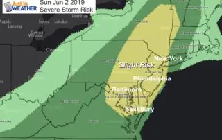
Sunday June 2 2019 The weekend started off nicely, but there were some heavy thunderstorms last night in Pennsylvania and northern Maryland. Today, the action will shift a bit to
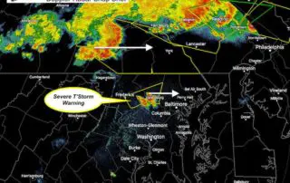
Thursday May 30 2019 Tornado Warning until 3:45 PM in Howard County between Columbia and Ellicott City. But its sals really bad north into Sykesville and Eldersburg. Look out
Thursday May 30 2019 As we spend another day with a risk of severe storms, we are waiting for the atmosphere to ignite with heat of the day to trigger
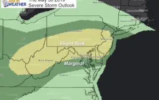
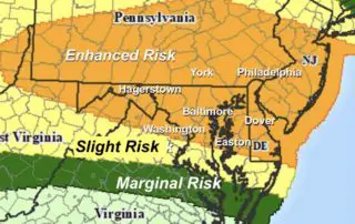
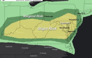
Thursday May 30 2019 Here we go again! The Storm Prediction Center has our region in the Slight Risk category for storms to turn severe today. This term may be
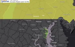
5 PM Wednesday May 29 A Tornado Watch was issued earlier for much of Pennsylvania, Cecil County MD, and northern Delaware. The important issue here is that a recent Severe
May 29 2019 Today will bring us high heat into the mid 90s and a trigger in the atmosphere to use that fuel for storms to form. The Storm Prediction
Tuesday Afternoon May 28 2019 A Tornado Watch has been issued for much of Pennsylvania until 10 PM. This includes Adams, York, and Lancaster Counties boarding Maryland. But south of

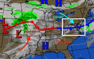
Tuesday May 28 2019 Some showers and a few lighting strikes this morning are moving through. This is what is left over from severe storms in the Mid West last
Memorial Day Monday May 27 2019 After a round of rough storms last night, we get in to a Canadian Air Mass the holds out temperatures and humidity down with
Sunday May 26 2019 We continue in a pattern of strong and severe storms. In similar fashion to yesterday, we will have a nice day with the chance of strong