June 18 Weather Under The Low Anything Can Go
Thursday June 18 2020 That cut off Low has wondered north across the Virginia and West Virginia border. We are in the warmer and more humid flow from the Southeast
Thursday June 18 2020 That cut off Low has wondered north across the Virginia and West Virginia border. We are in the warmer and more humid flow from the Southeast
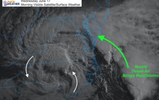
Wednesday June 17 2020 This morning's visible satellite shows the upper level cut off Low over North Carolina. This is responsible for bringing back the clouds and pumping in the

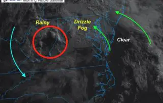
June 16 2020 The 'cut off' Low is the Carolinas is slowly creeping north. It has made for a spectacular satellite loop this morning, which highlights the circulation and easterly
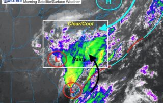
June 15 2020 We are threading the needle this morning with a very delicate balance of clear cool air to the north and persistent rain to the south. This is
Thursday June 11 2020 Something really interesting is unfolding today. The air is thick this morning across much of our region. The cold front that will bring in a cooler
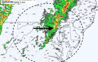
Wednesday June 10 2020 The local focus on storms may be two-fold: One round this evening, then another close to sunrise on Thursday. Then we will watch that front cross
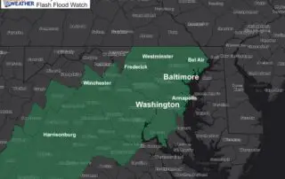
Wednesday June 10 2020 Today will be the peak of the heat with this weather chapter. The increasing humidity will bring the heat index close to 100ºF for some areas.
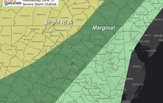
Friday June 5 2020 Another round of thunderstorms are expected today. Temperatures will be a little lower and the storms may be less intense. There is still a chance of
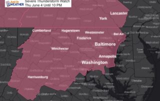
Thursday June 4 2020 Here we go again. The atmosphere is primed to produce severe thunderstorms today, with the focus shifting to the more densely populated central Maryland and Washington
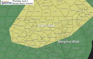
Thursday June 4 2020 After the derecho hit Pennsylvania and New Jersey yesterday, there is heightened anxiety for storms today. The energy will be shifting south and now puts central