Rain Today Then Turning Colder With Frost Possible Later This Week
Monday October 15 2018 Today will be the warmest day of the week, and it comes with rain. Showers are with us this morning and will be scattered for much
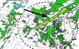
Monday October 15 2018 Today will be the warmest day of the week, and it comes with rain. Showers are with us this morning and will be scattered for much
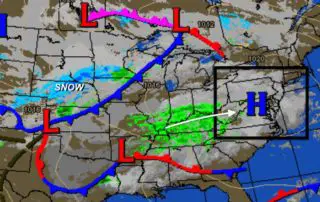
Sunday October 14 2018 Rain is moving in today for us as the overall weather map looks a bit like winter. Quite the contrast from a major hurricane just a
Saturday October 13 2018 A band of rain this morning is the mark of our pattern change. Fall is really here now and will stay. It is interesting how Hurricane
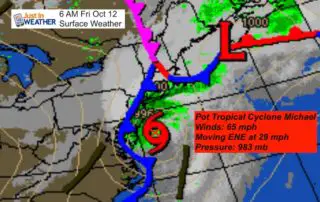
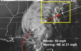
Friday October 12 Michael is now off the coast and The National Hurricane Center has identified it as Post Tropical Cyclone. It is moving to the ENE at 29 mph,
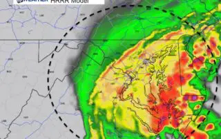
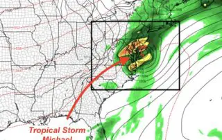
Thursday October 11 2018 Rain has already passed through this morning but the bulk of what we will see will be tonight. The impact of Tropical Storm Michael will be
Michael was the strongest October Hurricane to hit the Florida Panhandle on record and it maintained major hurricane intensity as it moved inland to Georgia. That is the first time
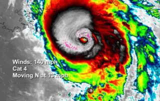
Wednesday October 10 2018 Hurricane Michael continues to strengthen overnight and is now poised to be the strongest storm to hit the Gulf Coast of Florida on record. Winds this
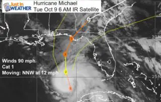
Tuesday October 9 2018 It is all about Hurricane Michael. A State of Emergency has been declared for parts of Alabama and Florida with Hurricane and Storm Surge Warnings extending

Monday October 8 2018 No rest for the weary. We have fog problems and Tropical Storm Micheal is expected to become a hurricane today. Hurricane Watches have been issue for
Sunday October 7 2018 We are still in a pattern locally with morning fog and some drizzle, then warm afternoons. Today we reach the 80s and stay near 80ºF much