Sunday October 7 2018
We are still in a pattern locally with morning fog and some drizzle, then warm afternoons. Today we reach the 80s and stay near 80ºF much of the week ahead. But an earlier end to the warm spell is in sight thanks to a tropical cyclone. This is a pattern adjusting type storm. It will help drag in colder air and make it truly feel like autumn next weekend. But I also will be watching, plotting, and remembering how this tracks because it may play into my Atmospheric Memory Theory for winter events a few months away.
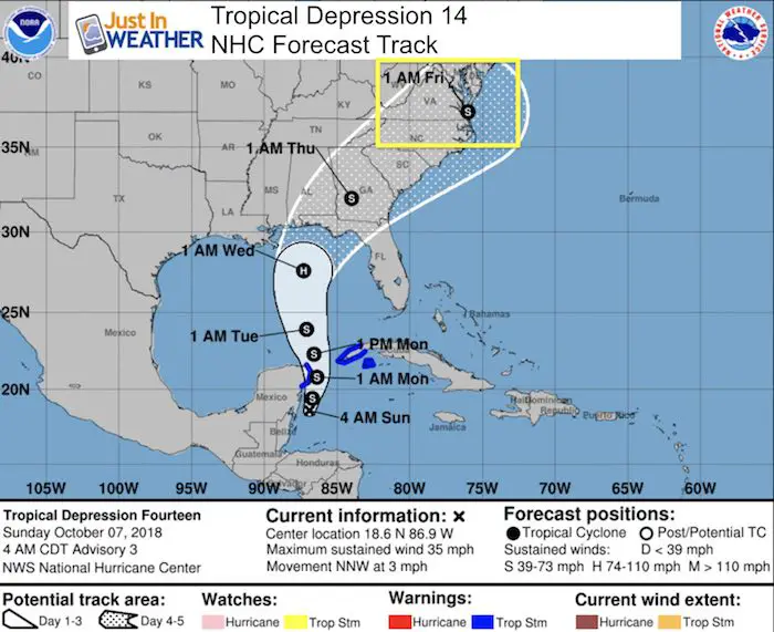
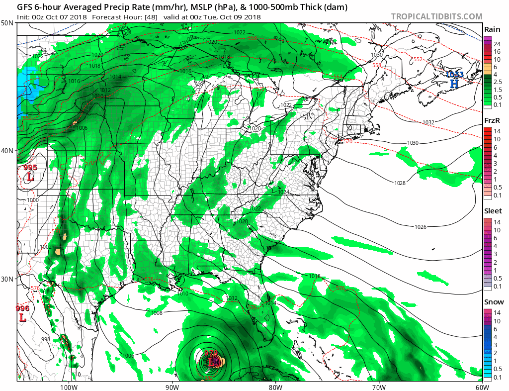
This is the National Hurricane Center forecast track. The expectation is that this will become a tropical storm later today and be named Michael. This will travel north into the Gulf of Mexico and briefly reach hurricane intensity. Then the track will move from landfall on Florida’s western Panhandle and curve towards Virginia Beach, just south of Maryland. Below is a look at the latest satellite, forecast models, and rainfall.
Local Weather Stats For October 7 in Baltimore
Average High: 71ºF
Record High: 96ºF in 1941
Average Low: 49ºF
Record Low: 35ºF in 2001
Sunrise: 7:08 AM
Sunset 6:39PM
*Daylight = 2:31 shorter than yesterday
*Bay Water Temperature = 72ºF at Thomas Pt. Light House
Local Weather: Morning fog and low clouds will give way to a sunny afternoon with temps on the 80s. More fog possible Monday morning.
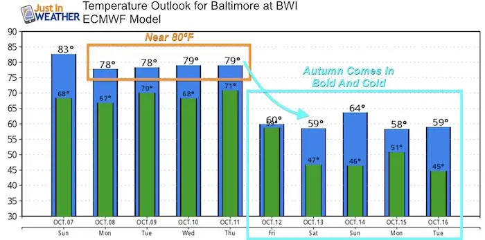
Since the next few days will be warm and quiet, see the temperature outlook below. This is a focus on TD 14 becoming TS Michael.
Also see:
Will A Wet Summer Bring A Snowy Winter?
Winter Outlook From Two Different Farmers Almanacs
Tropical Depression 14
As of this morning, Low Pressure just east of Mexico’s Yucatan Peninsula is looking more organized.
- Winds: 35 mph
- Moving North at 3 PM
A Tropical Storm Warning is in effect for...
* The Cuban provinces of Pinar del Rio and the Isle of Youth
* The coast of Mexico from Tulum to Cabo Catoche
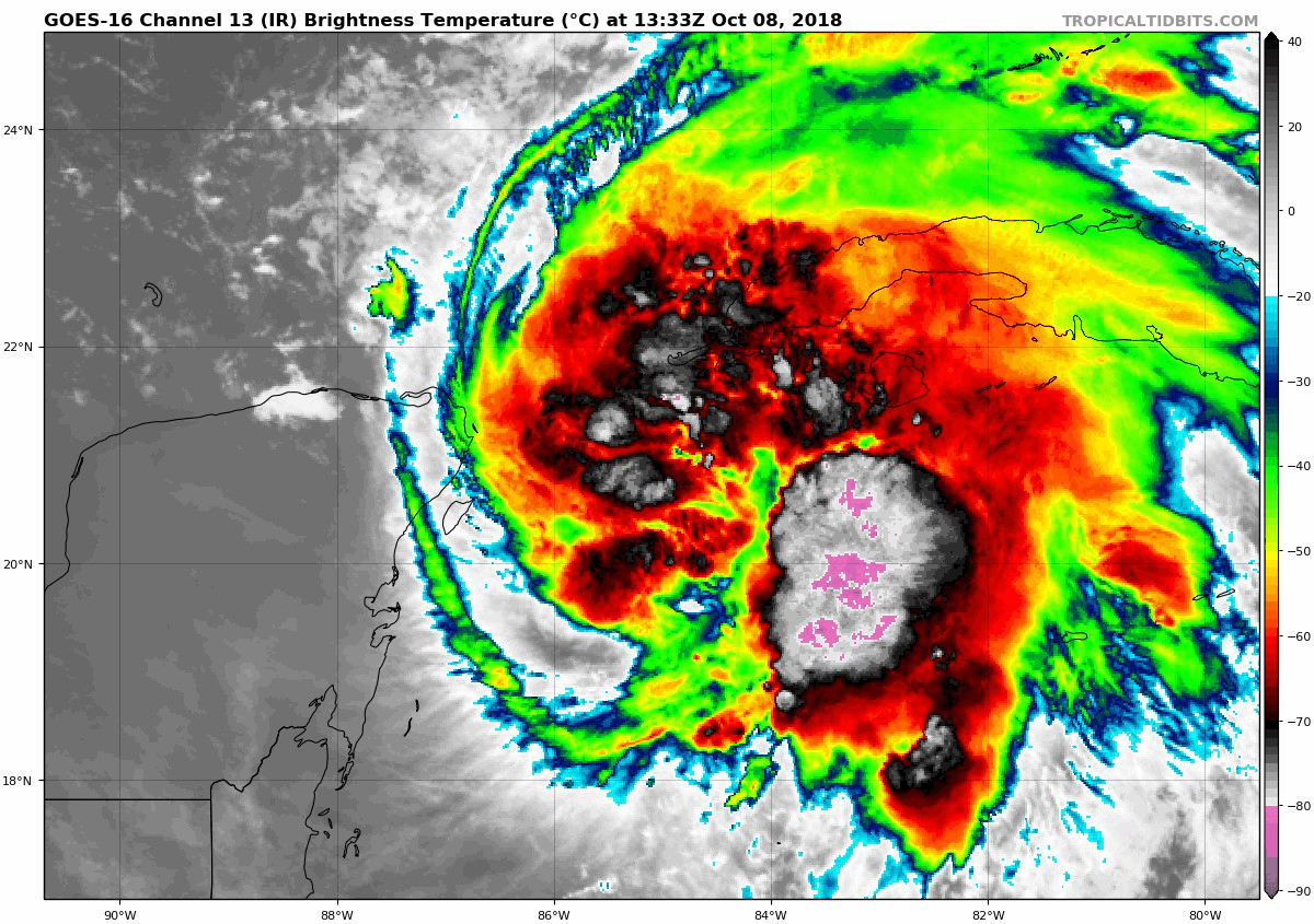
Satellite Loop
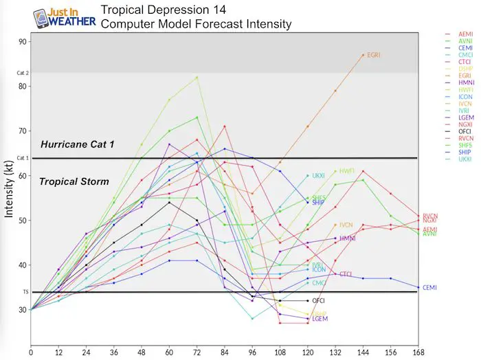
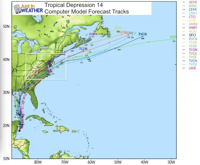
Computer Model Spaghetti Forecasts Plots
Intensity
Tracks
Forecast Animation:
This is the GFS Model that does have its limitation with tropical features. I am shoring this because there is a good agreement of the track and timing of the core Low. The rain intensity is still up for debate.
Any adjustment of tack and timing in the Gulf of Mexico can shift this heavy rain… It has shifted north (closer) since yesterday.
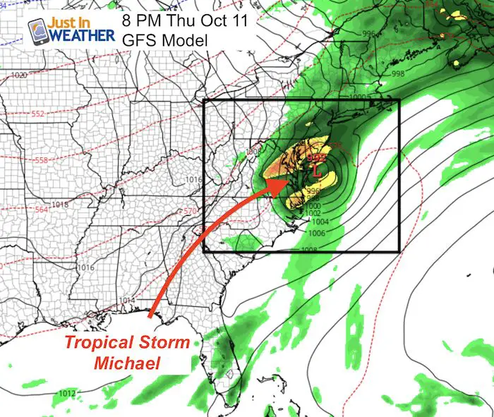
Snapshot
This is the GFS model plot showing the closest approach and passing just south of Ocean City Thursday evening. I still caution this precision at this time. As shown above, this storm is currently moving at only 3 mph. Any slight adjustment would shift the impact with a cold front and could chance the track and timing.
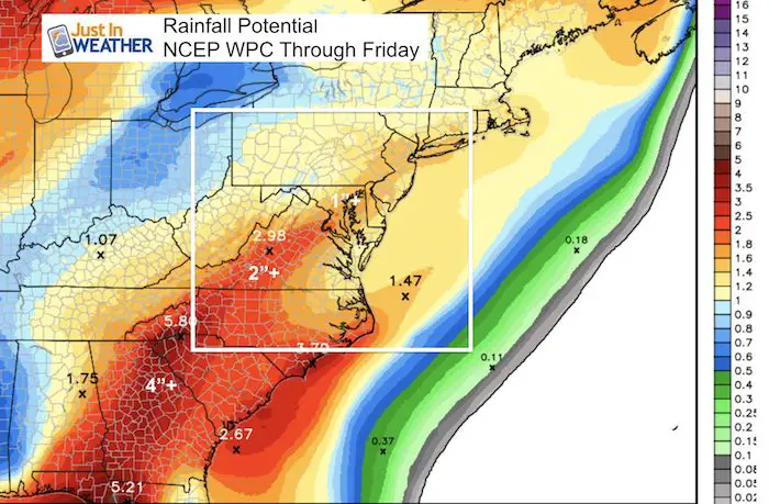
Rainfall Potential
As of now, we are on the edge of a 1 to 3 inch rain potential. But this ‘suggestion’ is subject to change with any shift in the size, speed, and track across the Gulf of Mexico as this develops.
Temperature Outlook
Temps near 80ºF through Thursday. After Michael passes, highs next weekend will be in the upper 50s to near 60ºF
Keep In Touch Every Day
Click here to sign up for email alerts…. Just in case you don’t get the post on your social media feed
Please share your thoughts, best weather pics/video, or just keep in touch via social media
-
Facebook: Justin Berk, Meteorologist
-
Twitter: @JustinWeather
-
Instagram: justinweather
Love Maryland Shirt Designed By Jaiden
 |
|
This shirt was designed by my ‘bonus’ daughter Jaiden. All proceeds will go to Just In Power Kids and free holistic therapy for kids in and post cancer treatment.
Show your love for Maryland and make this 14 year old artist extra proud
|
![]()
 Get the award winning Kid Weather App I made with my oldest son and support our love for science, weather, and technology. Our 3 year anniversary of the release and our contribution to STEM education is this November. It has been downloaded in 60 countries, and works in both temperature scales. With your support we can expand on the fun introduction to science and real weather.