Wednesday October 10 2018
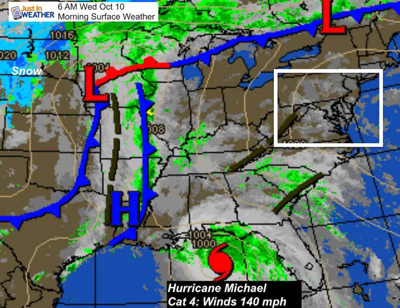
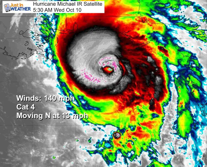
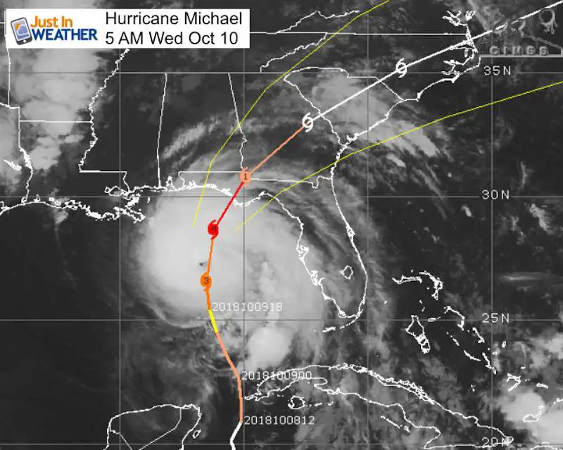
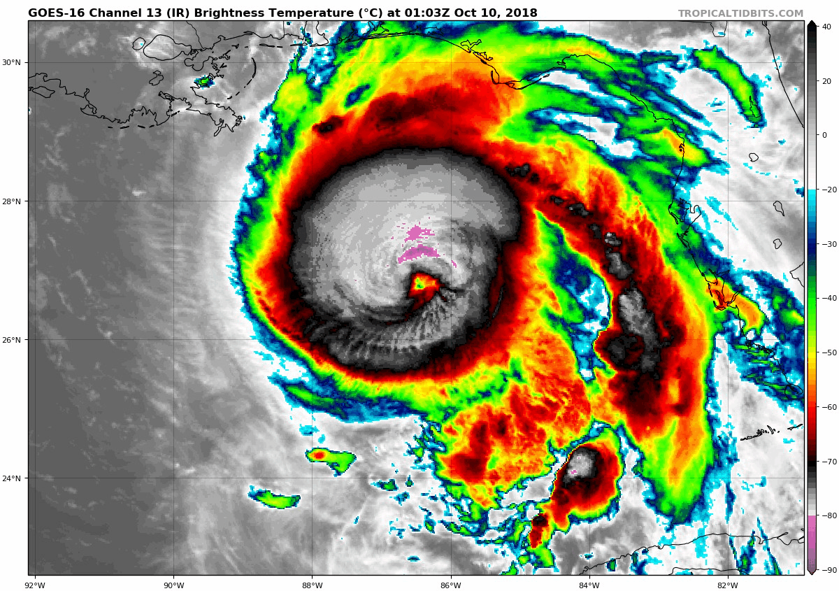
Hurricane Michael continues to strengthen overnight and is now poised to be the strongest storm to hit the Gulf Coast of Florida on record. Winds this morning are up to 140 mph making this a Category 4 storm. at 937 mb this is one of the strongest October storms on record and rivaling Hazel. It is a large storm and working on warm water should maintain intensity of get a little stronger before landfall today. The large pattern shows a deep trough in the central US producing snow in the northern plains. Strong High Pressure off of the east coast helping to steer and eventually speed up this storm, so it will be off of the Virginia Coast Friday morning.
This is going to be an historic devastating event. As much as you may have seen drama declared on TV before, this time is the real deal! See the satellite loops and local impact below.
Update: This satellite view was at sunrise. The interim report had 145 mph winds. It is trying to reach Cat 5 status before landfall.

Local Weather Stats For October 10 in Baltimore
Earliest Snow on record: 0.3″ in 1939
Average High: 69ºF
Record High: 93ºF in 1939
Average Low: 47ºF
Record Low: 34ºF in 1979
Sunrise: 7:11 AM
Sunset 6:34 PM
*Daylight = 2:30 shorter than yesterday
*Bay Water Temperature = 74ºF at Thomas Pt. Light House
Also see:
Will A Wet Summer Bring A Snowy Winter?
Winter Outlook From Two Different Farmers Almanacs
Locally: Today will be warm and humid again. Some morning fog/drizzle, then some afternoon showers. Rain will really arrive tonight and Thursday. I will focus on that in my next report.
Hurricane Michael
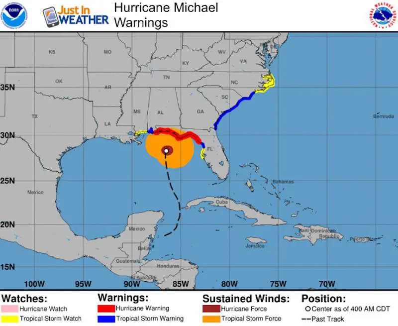
5 AM EDT Stats
LOCATION...28.3N 86.5W
ABOUT 140 MI...225 KM SSW OF PANAMA CITY FLORIDA
ABOUT 130 MI...215 KM SW OF APALACHICOLA FLORIDA
MAXIMUM SUSTAINED WINDS...140 MPH...220 KM/H
PRESENT MOVEMENT...N OR 360 DEGREES AT 13 MPH...20 KM/H
MINIMUM CENTRAL PRESSURE...937 MB
- Hurricane Force Winds reach 45 miles from the center
- Tropical Storm Force Winds reach 185 miles from the center
Short range Track
Landfall expected over Panama City Beach with the strongest side to the east (right). Apalachicola is expected to get the highest storm surge and heaviest rain.
Satellite Loop
Storm Surge Warning
Tyndall Air Force Base FL to Keaton Beach FL...9-13 ft
Okaloosa/Walton County Line FL to Tyndall Air Force Base FL...6-9 ft
Keaton Beach FL to Cedar Key FL...6-9 ft
Cedar Key FL to Chassahowitzka FL...4-6 ft
Chassahowitzka to Anna Maria Island FL including Tampa Bay...2-4 ft
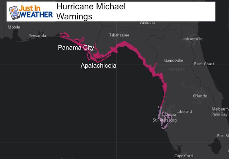
Hurricane Warning Area
A Storm Surge Warning is in effect for...
* Okaloosa/Walton County Line Florida to Anclote River Florida

A Storm Surge Watch is in effect for...
* Anclote River Florida to Anna Maria Island Florida, including
Tampa Bay

A Hurricane Warning is in effect for...
* Alabama/Florida border to Suwannee River Florida

A Tropical Storm Warning is in effect for...
* Alabama/Florida border to the Mississippi/Alabama border
* Suwanee River Florida to Chassahowitzka Florida
* North of Fernandina Beach Florida to Surf City North Carolina

A Tropical Storm Watch is in effect for...
* Chassahowitzka to Anna Maria Island Florida, including Tampa Bay
* Mississippi/Alabama border to the Mouth of the Pearl River
* Surf City North Carolina to Duck North Carolina
* Pamlico and Albemarle Sounds
Forecast Animations

GFS Model
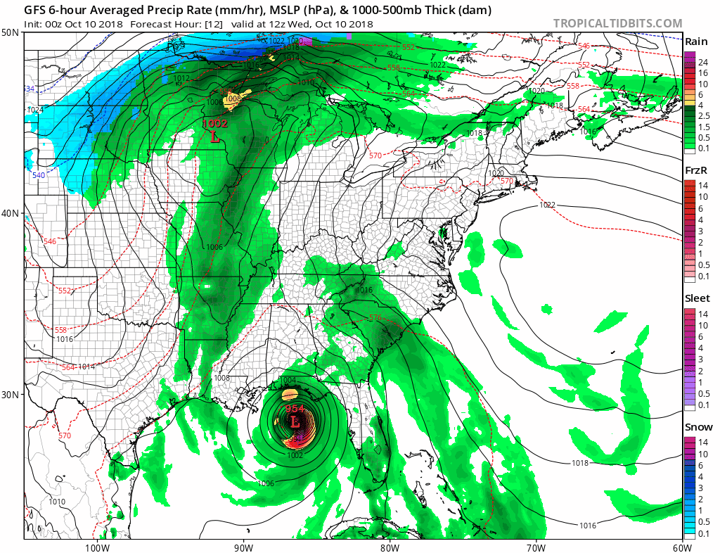
SnapShot
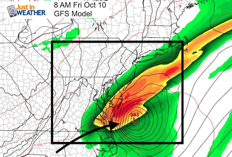
This is expected to stay south of Maryland with the Low crossing off the east coast Friday morning near Virginia Beach. But heavy rain and winds will reach southern Maryland.
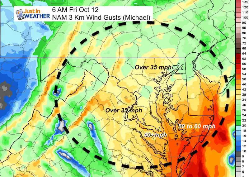
Top Winds
Gusty winds will reach metro Baltimore. But Tropical Storm Intensity will be felt in Southern Maryland and lower Delmarva
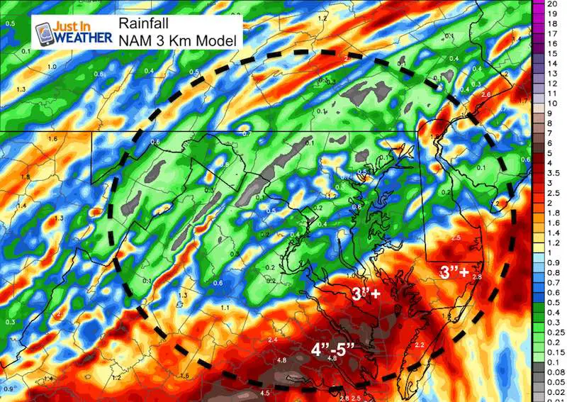
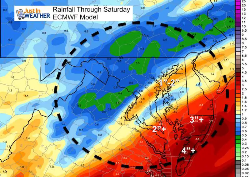
Rainfall
NAM 3 Km and Euro both show over 3 inches in Ocean City and southward. Metro Baltimore could get up to 1 inch
The storm will be moving away Friday morning. Then chilly but dry weather this weekend. I will have more on that in the next report
Keep In Touch Every Day
Click here to sign up for email alerts…. Just in case you don’t get the post on your social media feed
Please share your thoughts, best weather pics/video, or just keep in touch via social media
-
Facebook: Justin Berk, Meteorologist
-
Twitter: @JustinWeather
-
Instagram: justinweather
Love Maryland Shirt For Breast Cancer Research Foundation
 |
|
This shirt was designed by my ‘bonus’ daughter Jaiden. This is a limited edition (available in Ts, Long Sleeve, and Hoodies). At least $5 per shirt will go to BCRF. Purchase by Wednesday night and be entered to win a Maryland SnowStix or tickets to Greenstreet Gardens Fall Festival.
Show your love for Maryland and make this 14 year old artist and her mom extra proud
|
![]()
 Get the award winning Kid Weather App I made with my oldest son and support our love for science, weather, and technology. Our 3 year anniversary of the release and our contribution to STEM education is this November. It has been downloaded in 60 countries, and works in both temperature scales. With your support we can expand on the fun introduction to science and real weather.