5:45 PM Tuesday October 9 2018
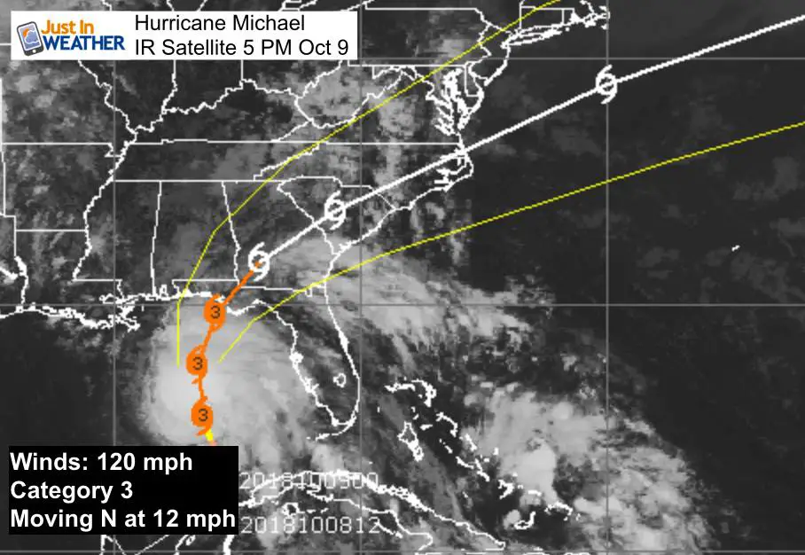
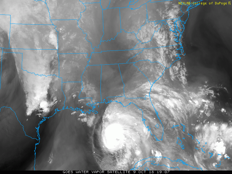
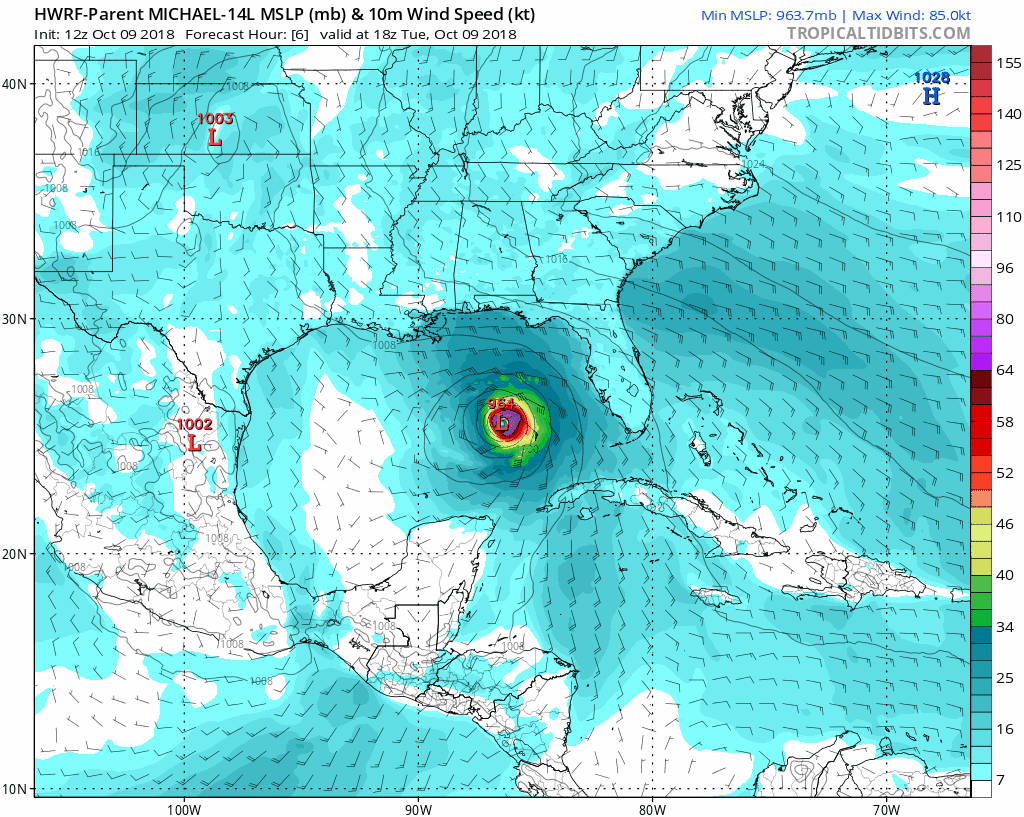
I think this now has everyone’s attention. Major Hurricane Michael now has top winds of 120 mph and it looks like it may continue to intensify tonight. The latest satellite imagery shows the rapid build up and expansion of the high clouds around the center. The warm water and light sheer has ideal conditions for this to continue to rival the destruction of Florence.
Key Stats at 5 PM EDT
- Winds 120 mph
- Category 3
- Moving North at 12 mph
- Hurricane Wind Field= 45 mile from center
- Tropical Storm Force Winds = 175 miles from the center
A Storm Surge Warning is in effect for...
* Okaloosa/Walton County Line Florida to Anclote River Florida

A Storm Surge Watch is in effect for...
* Anclote River Florida to Anna Maria Island Florida, including
Tampa Bay
* Alabama/Florida border to Okaloosa/Walton County Line Florida

STORM SURGE FORECAST
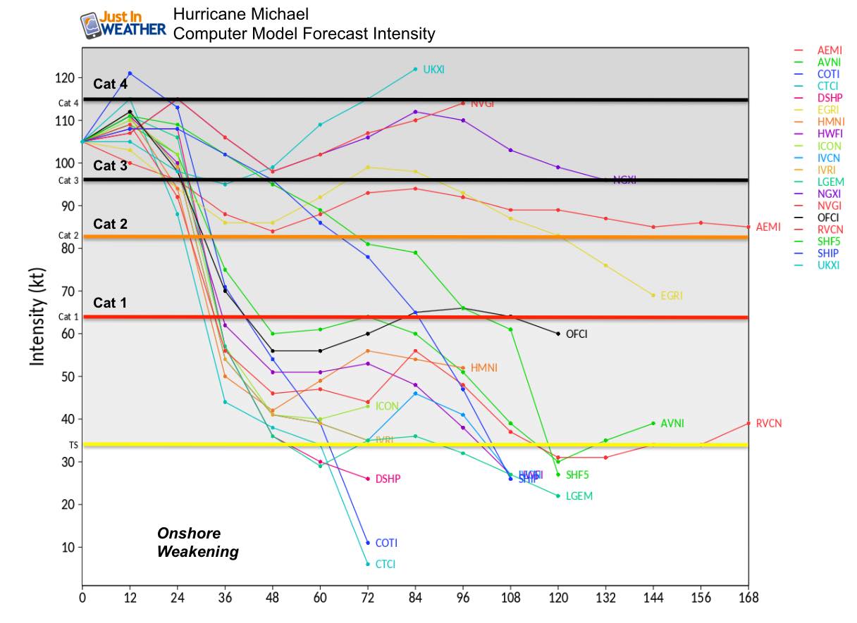
Mexico Beach FL to Keaton Beach FL...9-13 ft
Okaloosa/Walton County Line FL to Mexico Beach FL...6-9 ft
Keaton Beach FL to Cedar Key FL...6-9 ft
Cedar Key FL to Chassahowitzka FL...4-6 ft
Chassahowitzka to Anna Maria Island FL including Tampa Bay...2-4 ft
Alabama/Florida border to Okaloosa/Walton County Line FL...2-4 ft


Forecast Remains Cat  or maybe a 4 at landfall
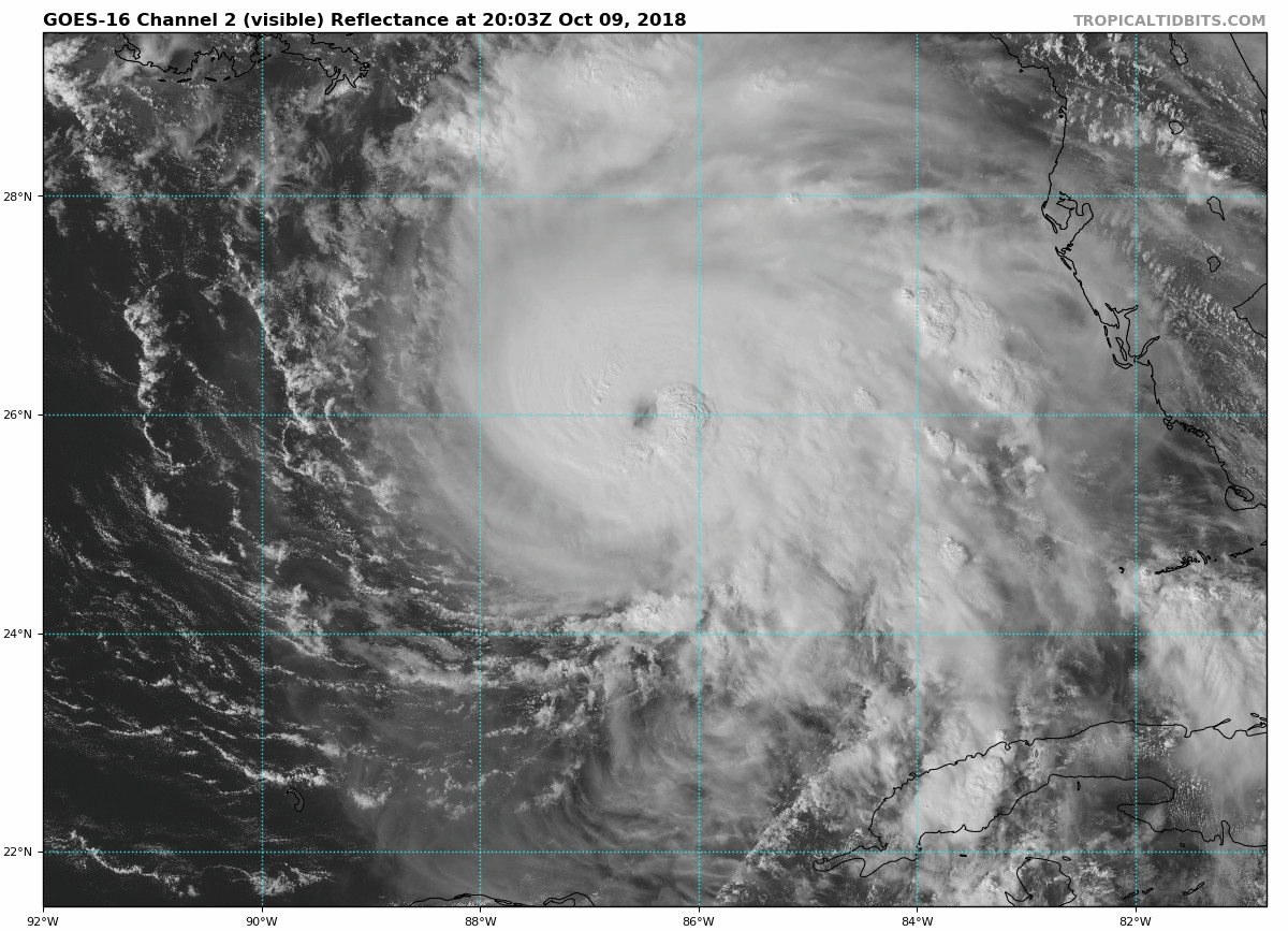
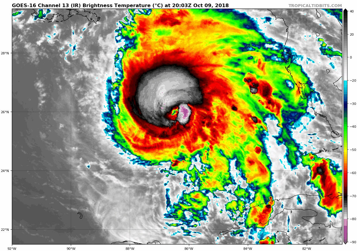
Satellite Loops
Visible
Infrared
Wide Water Vapor
This will not be a stall and crawl flooding event. It will speed up and move away in a hurry. But the slope of the Gulf Coast shoreline may take the 13 foot peak storm surge and lead to widespread destruction across parts of Florida.
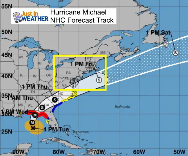
National Hurricane Center Forecast Track
Warnings
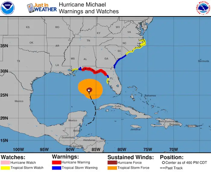
A Hurricane Warning is in effect for...
* Alabama/Florida border to Suwannee River Florida
A Tropical Storm Warning is in effect for...
* Alabama/Florida border to the Mississippi/Alabama border
* Suwanee River Florida to Chassahowitzka Florida
* Fernandina Beach Florida to South Santee River South Carolina
A Tropical Storm Watch is in effect for...
* Chassahowitzka to Anna Maria Island Florida, including Tampa Bay
* Mississippi/Alabama border to the Mouth of the Pearl River
* South Santee River South Carolina to Duck North Carolina
* Pamlico and Albemarle Sounds
Forecast Animation
Complete Forecast
The bulk of the the rain will stay to our south. Please click here to see my full forecast.
Keep In Touch Every Day
Click here to sign up for email alerts…. Just in case you don’t get the post on your social media feed
Please share your thoughts, best weather pics/video, or just keep in touch via social media
-
Facebook: Justin Berk, Meteorologist
-
Twitter: @JustinWeather
-
Instagram: justinweather
Love Maryland Shirt For Breast Cancer Research Foundation
 |
|
This shirt was designed by my ‘bonus’ daughter Jaiden. This is a limited edition (available in Ts, Long Sleeve, and Hoodies). At least $5 per shirt will go to BCRF. Purchase by Wednesday night and be entered to win a Maryland SnowStix or tickets to Greenstreet Gardens Fall Festival.
Show your love for Maryland and make this 14 year old artist and her mom extra proud
|
![]()
 Get the award winning Kid Weather App I made with my oldest son and support our love for science, weather, and technology. Our 3 year anniversary of the release and our contribution to STEM education is this November. It has been downloaded in 60 countries, and works in both temperature scales. With your support we can expand on the fun introduction to science and real weather.