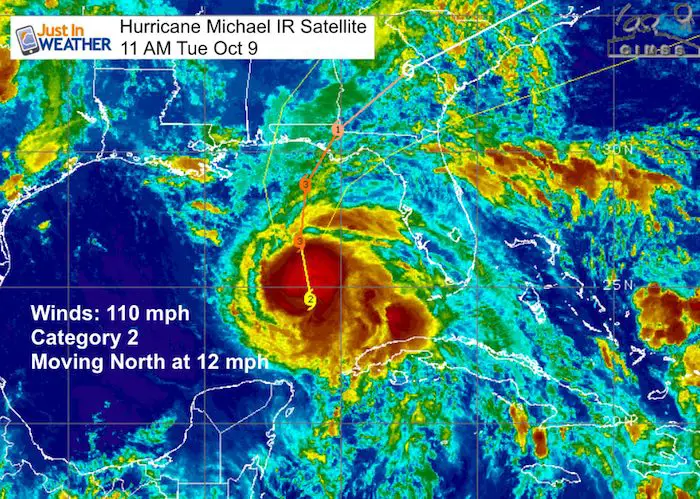
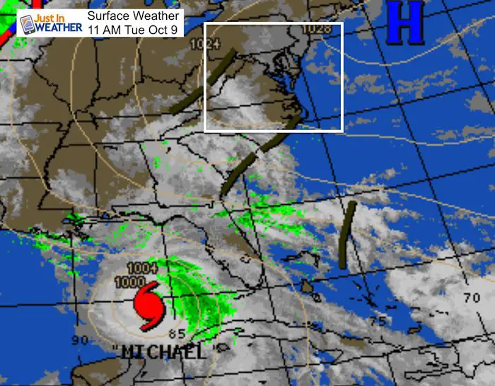
11 AM Tuesday October 9
Category 2 Hurricane Michael is fully utilizing the warm water in the Gulf of Mexico. As of the 11 AM update from the National Hurricane Center, winds are now 110 mph and it is moving to the North at 12 mph. This is a very dangerous situation as the storm is growing in a hurry and may peak just as it makes landfall on Florida’s Gulf Coast Wednesday. This is likely to be a Category 3 Major Hurricane (over 115 mph winds) later today. The satellite loops below support that strengthening.
Hurricane Force Winds extend 35 miles form the center
Tropical Storm Force Winds extend 185 miles from the center.
This Life-Threatening situation has three factors
- Storm Surge (may reach 12 Ft high)
- Heavy Rain up to 12 inches
- Winds: Category 3 would 115 mph or higher
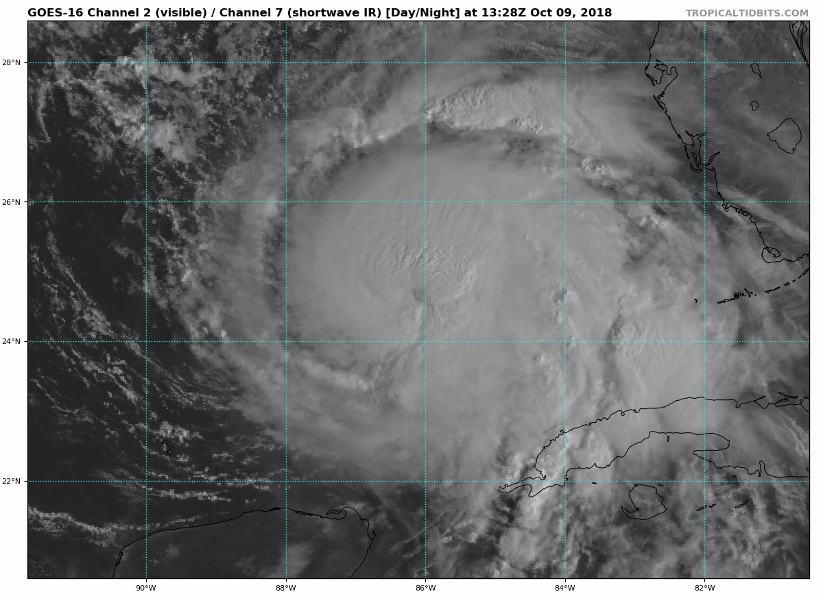
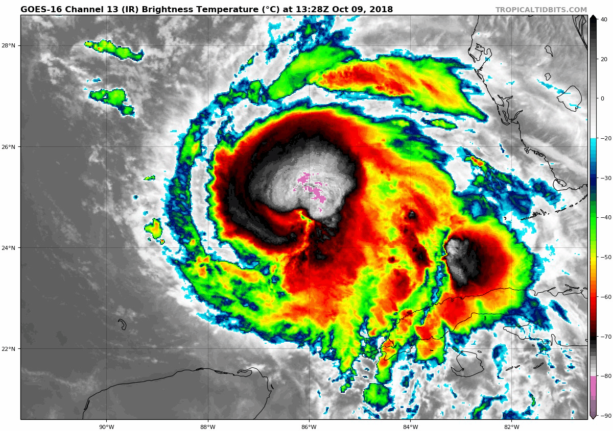
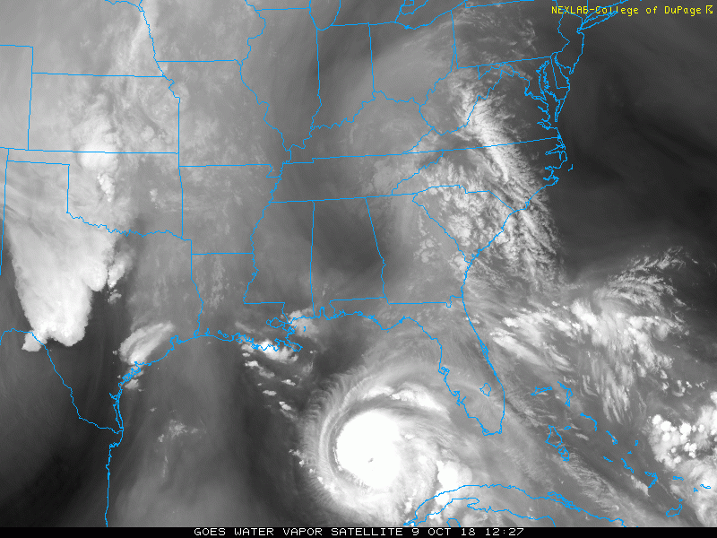
Satellite Loops
Visible Satellite
Infrared Stellite
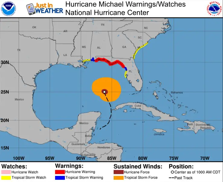
Warnings
A Storm Surge Warning is in effect for...
* Okaloosa/Walton County Line Florida to Anclote River Florida

A Storm Surge Watch is in effect for...
* Anclote River Florida to Anna Maria Island Florida, including
Tampa Bay
* Alabama/Florida border to Okaloosa/Walton County Line Florida

A Hurricane Warning is in effect for...
* Alabama/Florida border to Suwannee River Florida

A Tropical Storm Warning is in effect for...
* Alabama/Florida border to the Mississippi/Alabama border
* Suwanee River Florida to Chassahowitzka Florida

A Tropical Storm Watch is in effect for...
* Chassahowitzka to Anna Maria Island Florida, including Tampa Bay
* Mississippi/Alabama border to the Mouth of the Pearl River
* Fernandina Beach Florida to South Santee River South Carolina
Storm Surge Potential
Indian Pass FL to Cedar Key FL...8-12 ft
Cedar Key FL to Crystal River FL...6-8 ft
Okaloosa/Walton County Line FL to Indian Pass FL...6-9 ft
Crystal River FL to Aripeka FL...4-6 ft
Aripeka FL to Anna Maria Island FL including Tampa Bay...2-4 ft
Alabama/Florida border to Okaloosa/Walton County Line FL...2-4 ft
Wider View
Clouds well ahead of Michale are reaching the Maryland mountains this morning. This may produce some late day showers.. but rain will arrive Wednesday evening into Thursday.
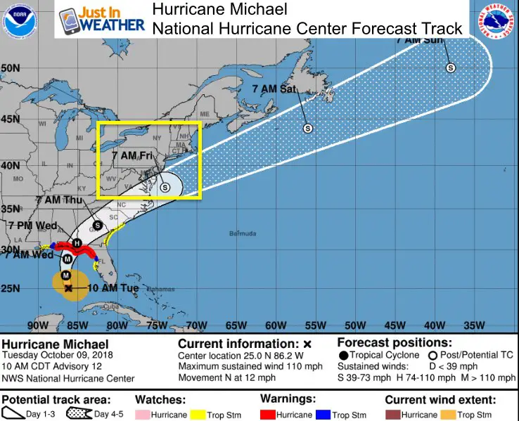
Forecast Track
Important notes:
- Florida will get hit the hardest. This will be very destructive from surge, wind speed, and rain flooding.
- Hurricane Michael will weaken to a Tropical Storm before reaching South Carolina.
- It will NOT stall, but increase in speed.
- The track stays south and weaken when it gets closer to Maryland but it could still produce some severe storms and isolated tornadoes.
- It will be moving away by Friday morning.
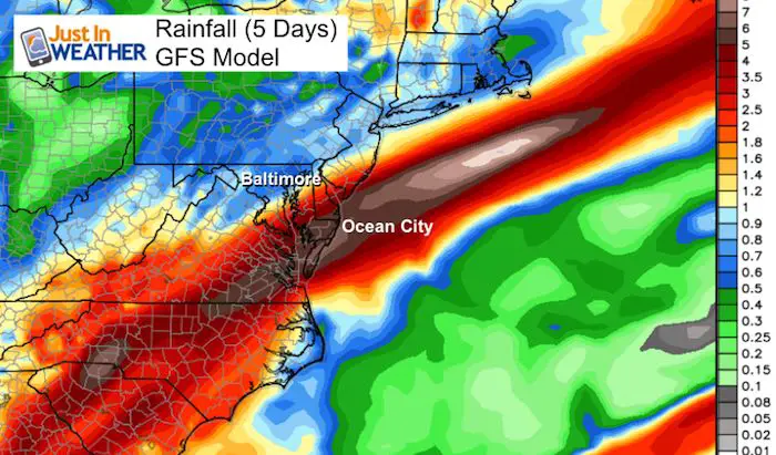
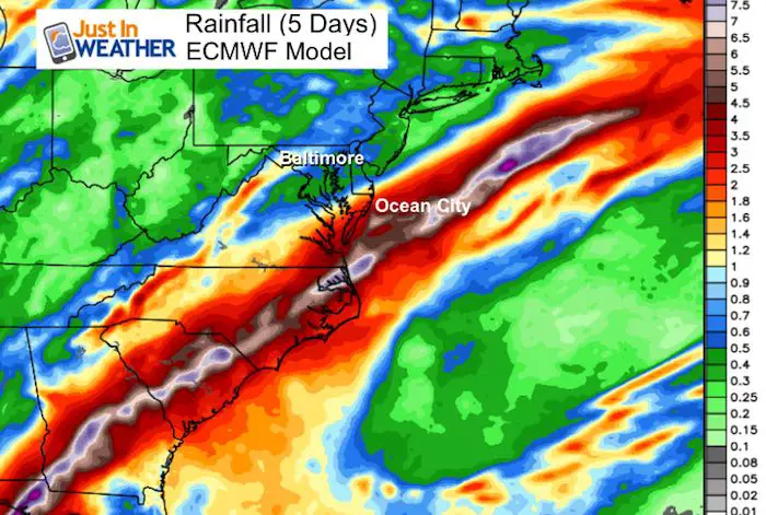
GFS Model Forecast Rain Timeline
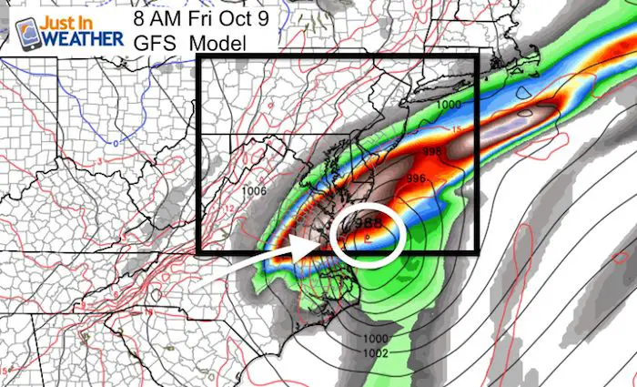
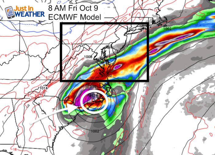
A stronger Micheal actually pulls the track to the right… or east. That will be devastating to the areas hit by Florence in September, but better news for us in the Mid Atlantic. The heaviest rain may reach Southern Maryland and Ocean City… but closer to Baltimore and north to York PA the rain will be more from a passing cold front.
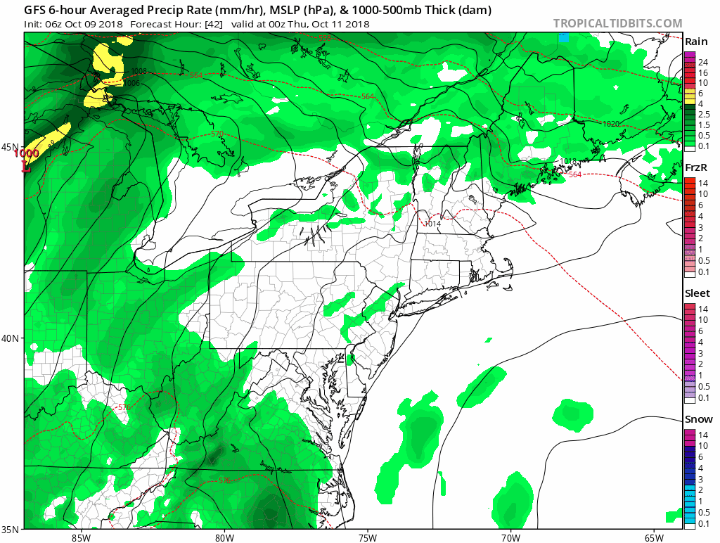
Here is a comparison of two main global models not agreeing on the track. The GFS (America) Model has it closer to Maryland while the ECMWF (European) Model has it farther south with a sharper turn.
| GFS Model (Closer) | European Model (Farther South) |
 |
 |
Rainfall Potential
Both models shows the heavy rain from Michael reaching as far north as Ocean City and possibly Delaware. But locally our rain in central MD and PA wil be form the cold front pushing Michael off of the coast.
Keep In Touch Every Day
Click here to sign up for email alerts…. Just in case you don’t get the post on your social media feed
Please share your thoughts, best weather pics/video, or just keep in touch via social media
-
Facebook: Justin Berk, Meteorologist
-
Twitter: @JustinWeather
-
Instagram: justinweather
Love Maryland Shirt For Breast Cancer Research Foundation
 |
|
This shirt was designed by my ‘bonus’ daughter Jaiden. This is a limited edition (available in Ts, Long Sleeve, and Hoodies). At least $5 per shirt will go to BCRF. Purchase by Wednesday night and be entered to win a Maryland SnowStix or tickets to Greenstreet Gardens Fall Festival.
Show your love for Maryland and make this 14 year old artist and her mom extra proud
|
![]()
 Get the award winning Kid Weather App I made with my oldest son and support our love for science, weather, and technology. Our 3 year anniversary of the release and our contribution to STEM education is this November. It has been downloaded in 60 countries, and works in both temperature scales. With your support we can expand on the fun introduction to science and real weather.