Storm Update and Radar Simulation For Wed Aug 2
Wednesday August 2 Severe storms have erupted early this afternoon as suggested this morning. If you followed my posts online I showed the castleling clouds and then the early pop

Wednesday August 2 Severe storms have erupted early this afternoon as suggested this morning. If you followed my posts online I showed the castleling clouds and then the early pop

Wednesday August 2 We don't have an organized severe storm risk today, but we are under the influence of a very humid air mass. The morning surface map shows the

Friday July 28 Many people have written me saying the radar this evening looks like a tropical storm ever the Mid Atlantic. In fact if this was a winter storm,

Friday July 28 A band of heavy rain developed this morning has has already produced over 1.5 inches of rain near Arbutus and between 2 and 4 inches in Montgomery

July 27 2017 3:45 PM A Flash Flood Watch has been issued for much of our region beginning 2 PM Friday July 28 into 2 PM Saturday July 29. This
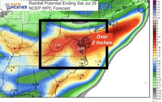
Unsettled weather has returned and well be with us into the start of the weekend. More clouds today, but if you see some sun pop through, that will help ignite

Wednesday July 26 High Pressure is in control, located over New York and Pennsylvania and helping to keep us cool again today. There is almost a hint of autumn in

Tuesday July 25 You will noting the drop in temperatures and humidity today. A fresh air mass has moved in and will keep most of our temperatures closer to 80ºF

Monday July 24 There will be heightened awareness and anxiety today following the likely tornado that hit Kent Island early this morning. Storms will develop and there is a marginal

Sunday July 23 The good news is that we do NOT have a Heat Advisory today, but that doesn't take away form the uncomfortable humidity. Temps will aim for near