 Wednesday August 2
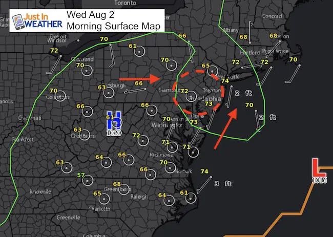
We don’t have an organized severe storm risk today, but we are under the influence of a very humid air mass. The morning surface map shows the subtle trough or weakness in the atmosphere over northeast Maryland and southeast Pennsylvania. This is where storms are expected to first fire up and it could be as soon as noon or 1 PM. Similar to the Bay Breeze Boundary over Baltimore yesterday, what develops could sit over the same location or drift in any direction. That is where the flooding threat comes in.
The radar simulation from the HRRR Model did a good job foreseeing the central Maryland cluster of storms yesterday. Some storms could drop a quick 1 to 2 inches of rain in less than an hour, leading to flooding again. So let’s take a look at how it play today out:
—-> slider
[metaslider id=50426]
Notice the concentration matches the area in the surface map above. I want to point out that this is a guide for timing and regional location, but may not be precise. But it is worth watching this afternoon for the first developing showers between York and Lancaster in PA, across the brother to northern Baltimore, Harford, and Cecil Counties in Maryland.
This does show Baltimore in on the action again as well… Another Bay Breeze boundary could set up mid afternoon somewhere between Baltimore, Washington, and Annapolis… and just drift.
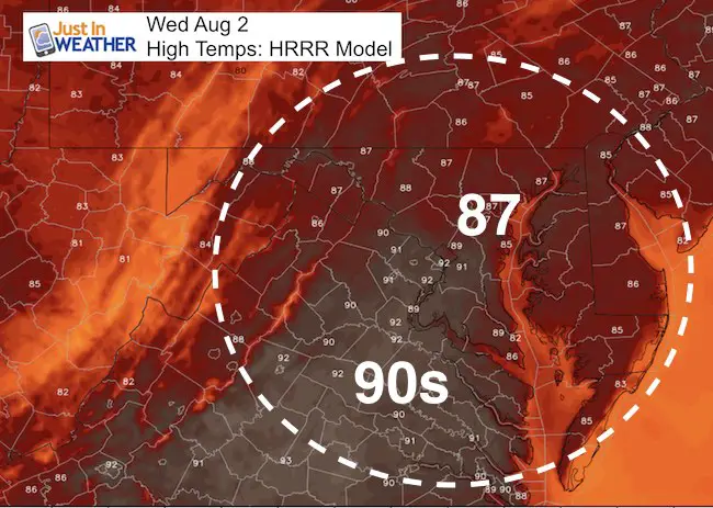
High Temperatures
Outlook:
Showers and storms will increase across the region over the next few days. Temperatures continue in the upper 80s and lower 90s. This should move out with morning showers Saturday, then clearing and a drop in humidity Sunday.
Please share your thoughts, best weather pics/video, or just keep in touch via social media
-
Facebook: Justin Berk, Meteorologist
-
Twitter: @JustinWeather
-
Instagram: justinweather
 Get the award winning Kid Weather App I made with my oldest son and support our love for science, weather, and technology. Our 3 year anniversary of the release and our contribution to STEM education is this November. It has been downloaded in 60 countries, and works in both temperature scales. With your support we can expand on the fun introduction to science and real weather.
Maryland Trek 2017
Donations now being accepted. Please select “Cool Kids Campaign” in the options to add to our entire team’s total.
Milestones this year:
- I will do my 1000th mile on Day 1 in Garrett County
- We aim to reach $100,000 for Cool Kids Campaign for the entire event.

Kent Island Tornado
Doppler Radar Loop: Likely Tornado On Kent Island July 24
Tornado Damage Photos On Kent Island: July 24 2017
Waterspout Video and Photos July 15 2017
Waterspouts photos August 21 2016
Faith in the Flakes
The store is closing for the season. Next week we wil be shifting back to spring mode. This will include a severe weather STEM assembly program.
-
Sign up for email updates on new posts
Since you may miss some posts via social media, click here for email alerts as a way to make sure you don’t miss any. *You may have to refresh that page once for your browser to clear out the images.
Also See: