Snow Timeline Update: Simulation Keeps Shifting West
February 4 at 9:45 PM - Every time I look at the latest short range high resolution radar, it keeps pulling the snow farther west. It doesn't look like much
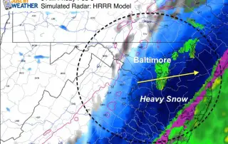
February 4 at 9:45 PM - Every time I look at the latest short range high resolution radar, it keeps pulling the snow farther west. It doesn't look like much
February 4- The front that was stalled is hanging back even longer. Below is an update radar simulation through 7 AM Friday. The only adjustment to my prior forecast is that

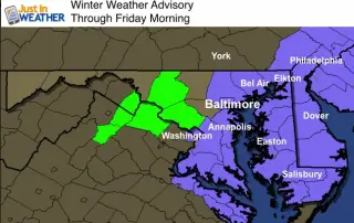
February 4- Yesterday we didn't get the record warmth, the rain lingered longer, and clouds held on today. UPDATE: Advisory now includes Baltimore and Washington. See the new radar simulation

February 4- Fog has lifted in the past few hours, west of the Chesapeake Bay. That is good news for many of us, where the Dense Fog Advisory has been cancelled!

January 3- We may not have gotten the record high today, but it was plenty warm with plenty of rain to wash away out recent winter hit. The blizzard of

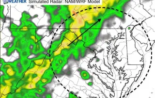
February 3 - A Flood Watch is in effect today through 5 PM Thursday. This is a combination of heavy rain, snow melt, and the mild air to follow allowing
February 2 - Now that we have had a chance to recover from the groundhog's tainted early spring prediction this morning, I've had a chance to analyze the week ahead.

January 31- We are about to close out the month with quiet weather, but it will not last long. There are a lot of changes on the way in the

January 29 - Today were are caught in between a very strong developing storm over the Atlantic and the upper level energy from the Great Lakes trying to catch up

January 28 - This is a quick look at the upper level energy that will pivot overhead on Friday. It will be unstable enough to bring cool wind, clouds, and