Updated July 1 Rain Timeline And Storm Concern
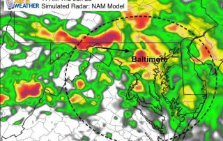
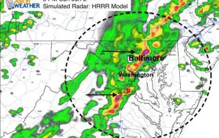
1:30 PM July 1- You may have noticed the humidity building along with the clouds. Rain and storms have already developing in southern Maryland as well as another line in
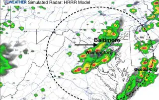
1:30 PM July 1- You may have noticed the humidity building along with the clouds. Rain and storms have already developing in southern Maryland as well as another line in

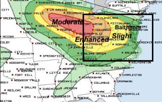
July 1 - Today will feel a little more humid and a little more typical of summer. But this will be short lived as a strong cold front will be

June 24 - Maryland is ripe for severe storms this week. Just a few days after the confirmed tornado in Howard County, the action shifted east and south. I was
June 22 - The moderate risk of severe storms in the Midwest can be clearly tracked to the southeast around a large upper level ridge. The trajectory overnight and radar
June 22 - The current boundary for severe storms will focus the energy around Chicago and the Mid West. This is around the edge of the Heat Dome that is

June 21 - Maybe it was National Shelfie not Selfie Day? The storms that erupted over central Maryland meant business and left a trail of destruction in its wake. Most

Tuesday June 21 - Today is the first full day of summer and we have a slight risk of storms turning severe. A cold front will be passing through and

Thursday June 16 - We start today with some fog and a very muggy environment thanks to rain overnight. There has been enough energy left over to produce lightning in
1 PM Sunday June 5 - Within a few hours the main line of storms will erupt ahead of a cold front. Warm air and the fast winds aloft will
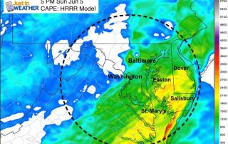
Sunday June 5 - Today is the day we have been expecting as the severe storm outlook will peak over our region. There will be showers to watch on radar