February 5 Weather Heavy Rain And Big Temperature Swings
Wednesday February 5 2020 Today marks 10 years since the epic two snowstorms Baltimore received in a 5 day span. It was February 5 -10 2010 when 50 inches of
Wednesday February 5 2020 Today marks 10 years since the epic two snowstorms Baltimore received in a 5 day span. It was February 5 -10 2010 when 50 inches of
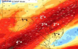
Tuesday February 4 2020 After breaking an 88 year old record high on Monday with a high of 67ºF in Baltimore, we will remain mild while getting into a wet

February 3, 2020 Baltimore just broke a record high temperature with 67ºF. This was the warmest February 3rd dating back to 1932, or 88 years ago! Winter is not normally
Tuesday January 28 2020 The weather map this morning once again looks quiet and our temperatures are cold but above average. The trend for the next few days will be
Sunday January 26 2020 This morning is cool, but still above average. We will get back there. The weather pattern for this week will be quiet locally, then turn stormy
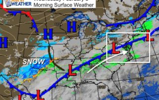
Saturday January 25 2020 Heavy rain fell overnight and the bulk of it has moved on this morning. We will still be in for showers through the morning, with an
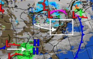
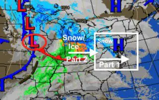
Saturday January 28 2020 10:10 AM Update Ice is on the way sooner and it may impact more areas. We are in the lull we discussed, but hard to call
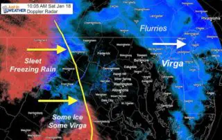
Saturday January 18 2020 The Winter Weather Advisory kicks in this morning as the first wave of snow moves in. Almost all is working out so far with the exception
Friday January 17 2020 Evening Update The break out of snow during Saturday morning is pretty much a lock. There is only a minor discrepancy of the start time among

Friday January 17 2020 The Winter Weather Advisory issued for Saturday by the National Weather Service just makes the forecast more official. It has been advertised all week and Saturday