Storm Damage Photos Around Baltimore County August 3 2017
Friday August 4 The severe thunderstorm that hit Baltimore County around 5:30 PM Thursday August 3 2017 produce amazing cloud formation and incredible damage. The first image here over Towson
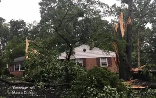
Friday August 4 The severe thunderstorm that hit Baltimore County around 5:30 PM Thursday August 3 2017 produce amazing cloud formation and incredible damage. The first image here over Towson

Friday August 4 Much of this week has featured severe weather across central Maryland, but Thursday August 3 it was centered on Baltimore County. The storm that moved through between

August 4 After a week filled with severe storms, we are not quite done yet. The action today will be a little different as we have a larger trigger in

Saturday July 29 The heavy rain lived up to expectations for most. Baltimore's BWI recorded 2.58" of rain, setting a new record for the date. The old mark of 2.28"

Friday July 28 Many people have written me saying the radar this evening looks like a tropical storm ever the Mid Atlantic. In fact if this was a winter storm,

Friday July 28 A band of heavy rain developed this morning has has already produced over 1.5 inches of rain near Arbutus and between 2 and 4 inches in Montgomery

Friday July 28 The rare summer storm expected to arrive will be developing high on top of our region. A Flash Flood Watch covers all of our region, plus there

July 27 2017 3:45 PM A Flash Flood Watch has been issued for much of our region beginning 2 PM Friday July 28 into 2 PM Saturday July 29. This

July 27 2017 A Flash Flood Watch has been issued for much of our region beginning 2 PM Friday July 28 into 2 PM Saturday July 29. This post is

Tuesday July 25 You will noting the drop in temperatures and humidity today. A fresh air mass has moved in and will keep most of our temperatures closer to 80ºF