 Friday July 28
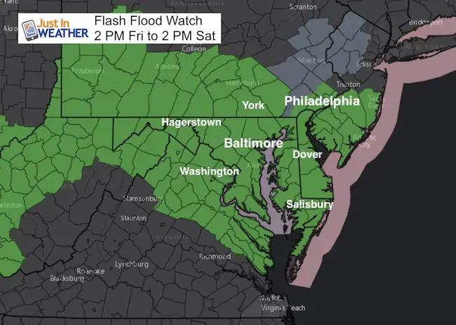
The rare summer storm expected to arrive will be developing high on top of our region. A Flash Flood Watch covers all of our region, plus there is a Small Craft Advisory on the Bay and Gale Watch for the beaches. As we look at the various computer models below, we can contrast the rain totals and location of the more intense bands. I want to add the caveat that we should not fall into the trap that these are perfect depictions. I prefer to look at the overall expectation for heavy rain intensity and timing. But, if this were a winter event we might notice model errors with a rain snow line. Keeping with the prior season errors I had identified, there is a tendency for large events to verify a little farther north. This will be important to pay attention to and I will point out any significant radar trends on or off point as this develops.
Main Points:
Friday: Showers this morning may be locally heavy. The widespread heavy rain develops during the afternoon and evening!
Friday night: Heaviest rain, flooding most likely!
Saturday: Rain intensity fades. Some afternoon clearing in PA. Showers will linger into the afternoon central and southern Maryland. High temperatures in the lower 70s.
Sunday: A nice day on the north side of Baltimore. Improving central/southern Maryland. Places that see the sun may get back to 80ºF
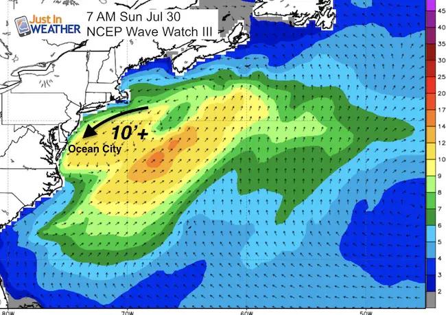
Beaches: May linger clouds and showers Sunday. Waves grow 10 Feet or higher Sunday into Monday.
Model Timelines And A Few Rainfall Total Forecast Maps
Simulated Radar: Friday
[metaslider id=50212]
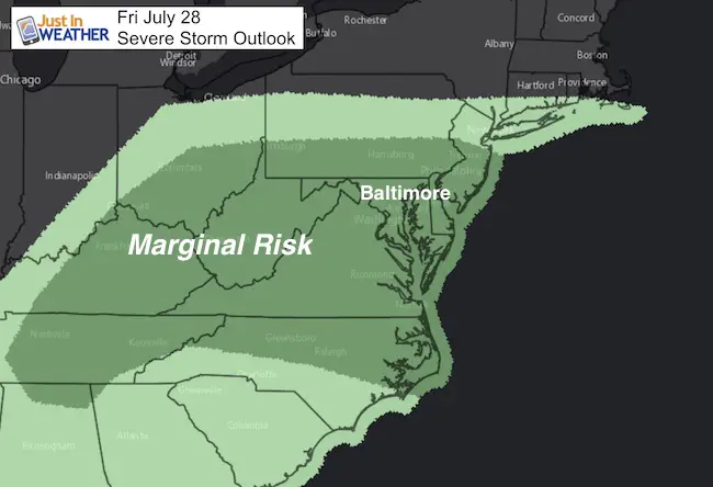
Severe Storms?
There is a slight risk for storms to turn severe. The biggest threat will be heavy rain
Rain Timeline This Weekend
[metaslider id=50188]
Coastal Problems After The Rain Ends
High Waves And Rip Currents Build Sunday
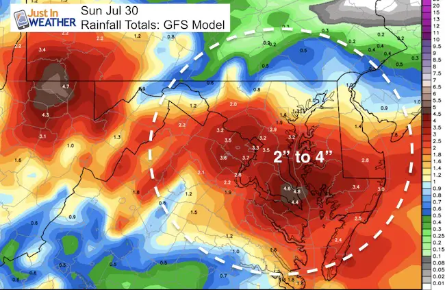
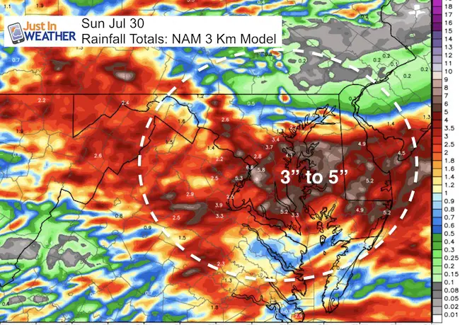
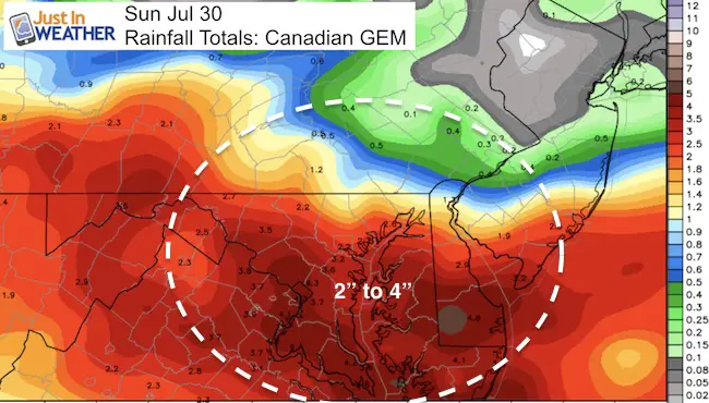
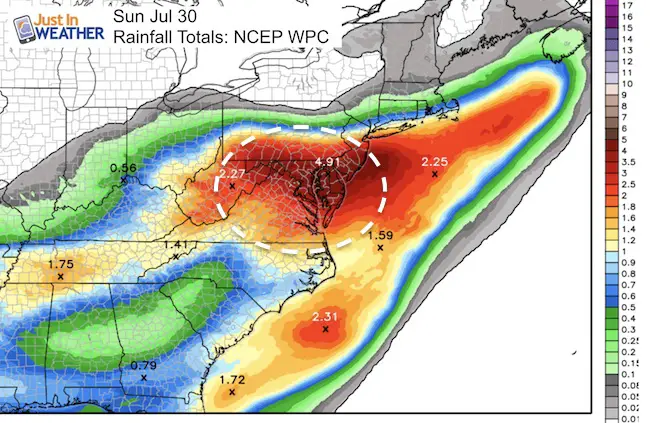
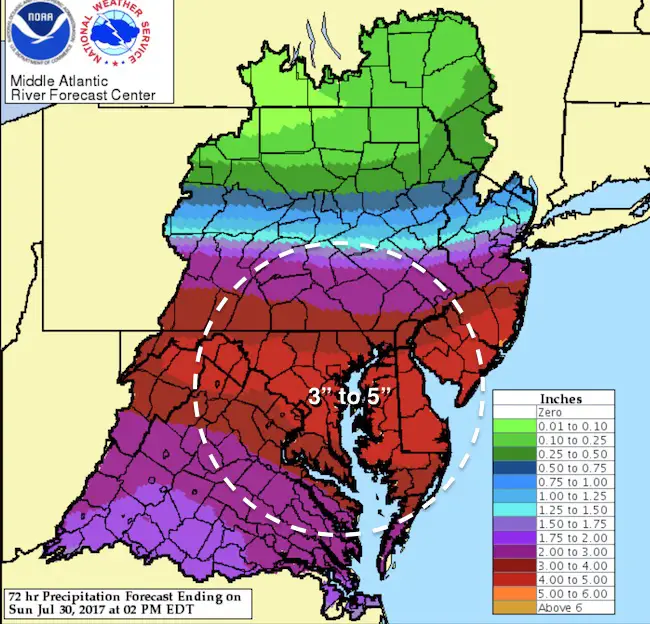
Rainfall Maps Ending Sunday:
Compare and Contrast… Models tend to agree the heaviest rain will be in the southern half of Maryland. We need to pay attention to the track and see if model error (verifying north) shows this time or has been resolved.
Please share your thoughts, best weather pics/video, or just keep in touch via social media
-
Facebook: Justin Berk, Meteorologist
-
Twitter: @JustinWeather
-
Instagram: justinweather
 Get the award winning Kid Weather App I made with my oldest son and support our love for science, weather, and technology. Our 3 year anniversary of the release and our contribution to STEM education is this November. It has been downloaded in 60 countries, and works in both temperature scales. With your support we can expand on the fun introduction to science and real weather.
Kent Island Tornado
Doppler Radar Loop: Likely Tornado On Kent Island July 24
Tornado Damage Photos On Kent Island: July 24 2017
Waterspout Video and Photos July 15 2017
Waterspouts photos August 21 2016
Maryland Trek 2017
Donations now being accepted. Please select “Cool Kids Campaign” in the options to add to our entire team’s total.
Milestones this year:
- I will do my 1000th mile on Day 1 in Garrett County
- We aim to reach $100,000 for Cool Kids Campaign for the entire event.

Faith in the Flakes
The store is closing for the season. Next week we wil be shifting back to spring mode. This will include a severe weather STEM assembly program.
-
Sign up for email updates on new posts
Since you may miss some posts via social media, click here for email alerts as a way to make sure you don’t miss any. *You may have to refresh that page once for your browser to clear out the images.
Also See: