Storm Analysis And Rain Timeline Overnight
Friday July 28 Many people have written me saying the radar this evening looks like a tropical storm ever the Mid Atlantic. In fact if this was a winter storm,

Friday July 28 Many people have written me saying the radar this evening looks like a tropical storm ever the Mid Atlantic. In fact if this was a winter storm,

Friday July 28 A band of heavy rain developed this morning has has already produced over 1.5 inches of rain near Arbutus and between 2 and 4 inches in Montgomery

Friday July 28 The rare summer storm expected to arrive will be developing high on top of our region. A Flash Flood Watch covers all of our region, plus there

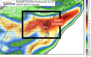
July 27 2017 3:45 PM A Flash Flood Watch has been issued for much of our region beginning 2 PM Friday July 28 into 2 PM Saturday July 29. This

July 27 2017 A Flash Flood Watch has been issued for much of our region beginning 2 PM Friday July 28 into 2 PM Saturday July 29. This post is
Unsettled weather has returned and well be with us into the start of the weekend. More clouds today, but if you see some sun pop through, that will help ignite

Wednesday July 26 High Pressure is in control, located over New York and Pennsylvania and helping to keep us cool again today. There is almost a hint of autumn in

Tuesday July 25 You will noting the drop in temperatures and humidity today. A fresh air mass has moved in and will keep most of our temperatures closer to 80ºF

July 22 207 We are about to compete the trifecta of storm lines today. If you have been tracking along with me and my reports today, then you know the

Friday July 14 Today is the day we break the heat, but we still have it along with a very humid feel to the air. A cluster of thunderstorms moved