A Warm Storm May Be Followed By Snow This Week
Sunday February 5 - Today is Super Bowl Sunday... A day last week that looked like we would have snow. Well, if you missed the updates over the past few days,
Sunday February 5 - Today is Super Bowl Sunday... A day last week that looked like we would have snow. Well, if you missed the updates over the past few days,

Saturday January 28 - The colder air is back this weekend, but it is all relative. Highs in the lower 40s gets us back just to 'normal' but it will

Wednesday January 25 - Today will be the nicest weather day in over a week, and for at least a week to get outside. Temperatures will reach the 50s ahead

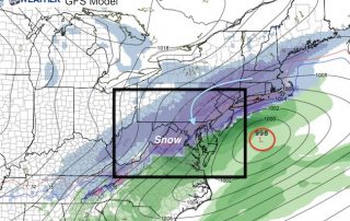
Monday January 23 - The strong Nor'Easter off of the Mid Atlantic coast may bring up memories of our record snowstorm a year ago, but this time the cold air

Monday January 23 - We are still under a Wind Advisory and there will be some bands of heavy rain this afternoon. Baltimore's BWI had a top gust of 43

Monday January 23 - A Wind Advisory is in place and it is already howling. At 6 AM area wind gusts are already pushing 35 mph, and expected to get stronger

A strong Nor'Easter will be developing on Monday. Rapid development is expected from the system that has produced deadly tornadoes across the Deep South this weekend. By the time you

Sunday January 22 - On this date last year we had a Blizzard Warning and the heaviest snowstorm in Baltimore history was underway. Now, just thick fog and waiting for

Wednesday January 18 - Thick fog remains in parts of our area as a reminder that the Chesapeake Bay governs much of our weather. This photo from Concord Point Lighthouse is

Tuesday January 17 - Today will be a wet day a yet another storm sends us the warm side with rain. Roads are damp already and more rain is on