A New Winter Weather Advisory For Friday Night To Saturday Morning
Friday March 1 2019 When I said that March was coming in like a lion, some people took issue with me. We had an average of 2 inches of snow

Friday March 1 2019 When I said that March was coming in like a lion, some people took issue with me. We had an average of 2 inches of snow
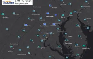
Thursday February 21 2019 If you had ice when you went to bed last night, then you have it this morning. Temperatures have barely moved and looking at local numbers,
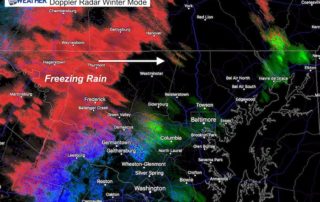
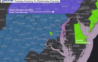
February 20 2019 The Winter Storm Warning and Winter Weather Advisory in place locally until 1 AM accounts for more freezing rain. We can see that on the radar tonight.

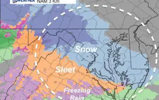
February 20 2019 So far the snow reached or exceeded expectations in most areas. Now we are on to phase 2 which is all about the ice. The storm is

February 20 2019 We are under a Winter Storm Warning under much of the area today. Now that the snow has broken through the dry air, you may have seen
Tuesday Evening February 19 2019 The weather map this evening is looking very impressive. A large band of rain and snow dominate the eastern half of the nation. It's developing
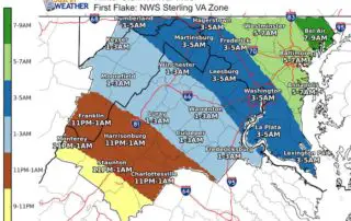
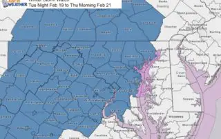
Tuesday February 19 2019 The Winter Strom on the way will be with us Wednesday morning. Most of the are should see the first flakes by daybreak, but here is
Monday February 18 2019 The Winter Storm Watch now includes all counties west of the Chesapeake Bay and Susquehanna River in our region. The timing across the area varies as
Monday February 18 2019 The big story is the Winter Storm Watch issued in central Maryland (there will be other areas to follow). The statement has it Tuesday evening to

4:30 PM Sun February 17 2019 Doppler Radar appears to be showing the arrival of our wintry weather a little ahead of schedule.The Winter Weather Advisory is still in place