Radar Simulation Thu Aug 3: Flash Flooding Possible Again
Thursday August 3 We remain in this humid environment on the edge of High Pressure that allows the storms to buildup, but not much push to move them. So as

Thursday August 3 We remain in this humid environment on the edge of High Pressure that allows the storms to buildup, but not much push to move them. So as

Wednesday August 2 Severe storms have erupted early this afternoon as suggested this morning. If you followed my posts online I showed the castleling clouds and then the early pop

Wednesday August 2 We don't have an organized severe storm risk today, but we are under the influence of a very humid air mass. The morning surface map shows the

August 1 At first glance, there is nothing out of the ordinary as we begin August. It will be hot and more humid. No big deal, right? The risk of

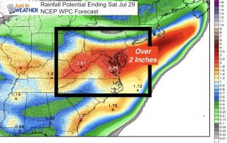
Saturday July 29 The heavy rain lived up to expectations for most. Baltimore's BWI recorded 2.58" of rain, setting a new record for the date. The old mark of 2.28"

Friday July 28 A band of heavy rain developed this morning has has already produced over 1.5 inches of rain near Arbutus and between 2 and 4 inches in Montgomery

Friday July 28 The rare summer storm expected to arrive will be developing high on top of our region. A Flash Flood Watch covers all of our region, plus there

July 27 2017 3:45 PM A Flash Flood Watch has been issued for much of our region beginning 2 PM Friday July 28 into 2 PM Saturday July 29. This

July 27 2017 A Flash Flood Watch has been issued for much of our region beginning 2 PM Friday July 28 into 2 PM Saturday July 29. This post is
Unsettled weather has returned and well be with us into the start of the weekend. More clouds today, but if you see some sun pop through, that will help ignite