Snow Sleet Freezing Rain and Definitions
Winter Precipitation: Snow Sleet Freezing Rain and more
Winter precipitation can best be described as a variation of frozen ‘stuff’ falling from the clouds. But what that stuff is depends on the layers of cold and relatively warmer air aloft between and into the cloud layer.
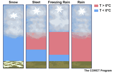
In the animation here, freezing is shown as 0°C, which is the same as 32°F. The blue layer is colder than freezing, while the red shading is above freezing.
In some storm set ups, a layer of warmer air can be sandwiched between cold air above and below. This is how that can affect the type of ‘stuff’ that falls.
See more winter weather definitions below.
Winter Precipitation
SNOW: Below freezing in the clouds and on the way down.
*It can snow when the surface air is warmer, but colder snowflakes don’t melt yet.
(INVERSION: A warmer layer of air in the middle of the middle of the atmosphere)
SLEET: A thin inversion melts snow or starts out as rain, then it refreezes on the way down to the ground. This ‘pings’ when it hits and can hurt. The layer of cold air near the ground is thick.
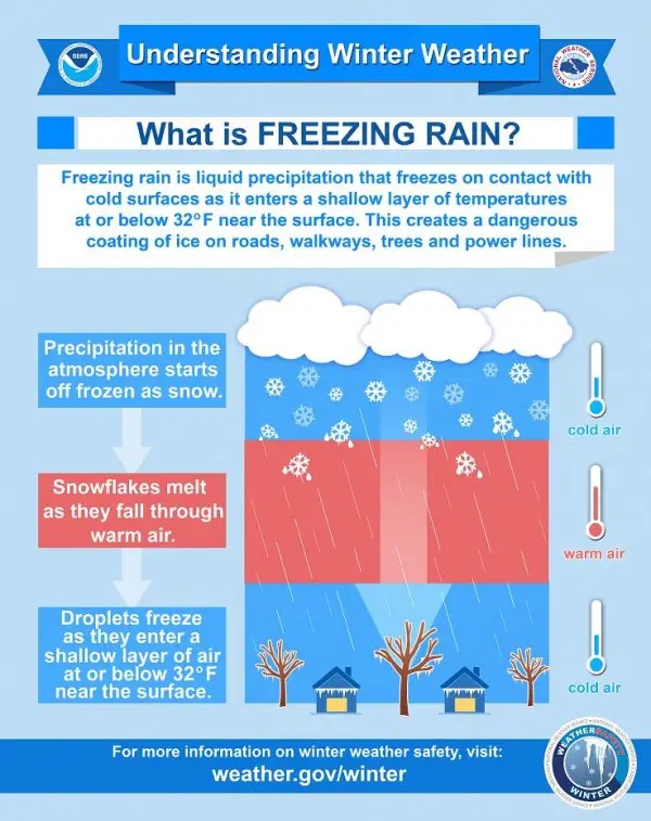
FREEZING RAIN: A thicker inversion melts snowflakes or starts as rain. The thin layer of freezing air near the ground is not enough to refreeze the precipitation. It will fall as rain, but freeze on contact with the surface.
RAIN: Warm enough above freezing all the way down to the ground.
*Graupel – Partially melted and refrozen snowflakes. The edges curl in and they look like tiny Styrofoam balls.
Definitions/Popular Terms
Advection – Air moving in from one place to another
Alberta Clipper – A fast moving storm originating in Alberta Canada that can drop a quick few inches of snow but often comes with very cold arctic air. This can also be a Saskatchewan Screamer.
Bomb (Bombogenesis) – When Low Pressure rapidly deepens at a rate of 1 mb per hour or faster. This is often marked by 24 mb or more in 24 hours.
Inversion – when the air temperature warms with height. It can be warmer on a hilll top and colder in a valley. This can also occur with a cold ground and warmer air above.
Lake Effect Snow – The cold air over the Great Lakes creating an unstable environment and heavy snow downwind. This usually stays close to the lakes and does not cross the mountains.
Nor’Easter – A strong storm off of the East Coast of the US. This moves to the North East, into the Northeastern US, and the winds for coastal areas come around form … the Northeast. Thus, three reasons this type of storm gets its name.
Overrunning – Warm air can rise over a cold air mass. So the clouds can be warmer than the ground. Hills can be warmer than valleys too. Hill top and colder in a valley. Same with a colder ground vs. warmer clouds.
Polar Vortex – This is a naturally occurring circulation of extreme cold around the North Pole. When this is weakened, it can wobble and shift southwards. When it is discussed reaching Canada or the northern US, that is when we get the most extreme cold.
Stickage – The process of snow laying and staying on the ground. There is no melting, just piling up to start the accumulation.
Sublimation – Snow skipping the melting and ice crystals going to gas form. It is not evaporation but rather sublimation.
Virga – Snow seen on radar but sublimating and appearing to dry up before reaching the ground.
Vintage Video:
My first use of the word ‘Stickage’ in late December 1974
My kids and dad helped me recreate this 😉
Faith in the Flakes
This phrase began with my son in 2009 when he was 3 years old.
Explore More: See how the origin of this is connected to The December 5th Snow Day History
All Winter Weather Resource Pages
Recent Articles
October 7 A Break Today But Weekend May Bring Rain From Coastal Storm
Thursday October 7 This morning we have already seen a
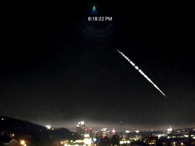
Fireball Video Over Pittsburgh Tuesday Evening October 5 2021
Wednesday October 6 2021 On Tuesday evening, a fireball was
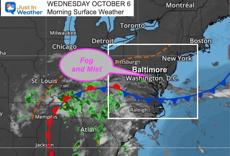
October 6 Weather Still Warm And Damp Tracking Narrow Band Of Rain
Wednesday October 6 This morning begins with fog and mist.
Please share your thoughts, best weather pics/video, or just keep in touch via social media
Facebook: Justin Berk, Meteorologist
Twitter: @JustinWeather
Instagram: justinweather
Winter Outlook Series


14 Local Maryland Pages (and York PA)
We have made a page for Maryland Weather which gives you the current conditions for 14 present area locations.

FITF Shop Open
My ‘bonus’ daughter Jaiden and wife showing off our popular Maryland Hoodies. Unisex and women’s items all produced in Maryland.
Click here to see this and many other new items.


Also see:
Maryland Weather Page
I wanted to keep it simple. Just the basics for a quick view at any time.

Just In Power Kids:
A portion of proceeds go to our programs Providing FREE holistic care for kids in cancer treatment and up to 5 years post treatment and caregivers.
![]()
New Caps and Hats

