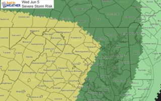
Tuesday June 4 Weather: Chilly Start Then Warming Up Fast And Severe Storm Risk Tomorrow
Tuesday June 4 2019 At sunrise this morning temperatures felt ore like mid April instead of early June. t 6 AM, BWI reported 48ºF. The record was 46ºF in 1964.
Tuesday June 4 2019 At sunrise this morning temperatures felt ore like mid April instead of early June. t 6 AM, BWI reported 48ºF. The record was 46ºF in 1964.
June 3 2019 The last round of storms that blew through was with a cold front. The local map was littered with sever storm reports, dominated by large hail. That
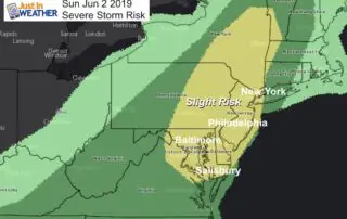
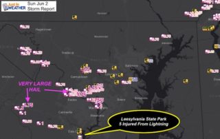
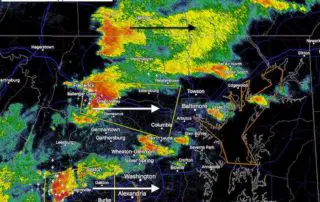
Sunday June 2 2019 The weekend started off nicely, but there were some heavy thunderstorms last night in Pennsylvania and northern Maryland. Today, the action will shift a bit to

May 31 2019 The active weather has brought the National Weather Service back to Howard County for the second time in the past week. The official survey crew investigated the
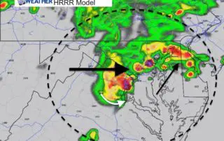
Thursday May 30 2019 Tornado Warning until 3:45 PM in Howard County between Columbia and Ellicott City. But its sals really bad north into Sykesville and Eldersburg. Look out
Thursday May 30 2019 As we spend another day with a risk of severe storms, we are waiting for the atmosphere to ignite with heat of the day to trigger
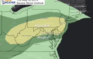
Thursday May 30 2019 Here we go again! The Storm Prediction Center has our region in the Slight Risk category for storms to turn severe today. This term may be
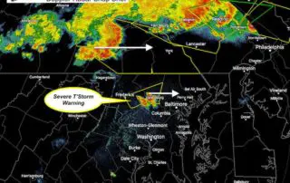
5 PM Wednesday May 29 A Tornado Watch was issued earlier for much of Pennsylvania, Cecil County MD, and northern Delaware. The important issue here is that a recent Severe
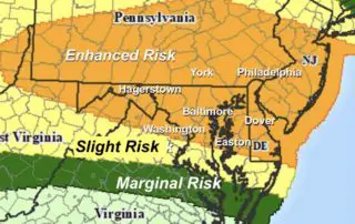
May 29 2019 Today will bring us high heat into the mid 90s and a trigger in the atmosphere to use that fuel for storms to form. The Storm Prediction

Tuesday May 28 2019 Some showers and a few lighting strikes this morning are moving through. This is what is left over from severe storms in the Mid West last